

Nagpur, often referred to as the "Geographical Heart of India," is undergoing a massive infrastructural metamorphosis. As the city transitions from a regional hub into a global logistics and industrial powerhouse, the demand for sophisticated transit networks has never been higher. While the city already benefits from an existing outer ring road and several bypasses, the Nagpur Metropolitan Region Development Authority (NMRDA) has set its sights on a far more ambitious project: the 148-km New Outer Ring Road, popularly dubbed the "Golden Arch."
This proposed third ring road is not merely a ribbon of asphalt; it is a strategic economic corridor designed to redefine the urban limits of Nagpur and facilitate the seamless movement of freight across the subcontinent.
1. The Vision Behind the ‘Golden Arch’: Beyond City Limits
For years, Nagpur’s traffic management relied on internal arterial roads and a secondary ring road that facilitated heavy vehicle movement around the city’s immediate periphery. However, with the rapid expansion of housing projects, warehouses, and industrial zones, these "outer" roads have increasingly become integrated into the urban fabric, leading to congestion and reduced efficiency for long-distance transit.
The New Outer Ring Road project is a forward-looking response to this urban sprawl. Planned much farther outside the current city limits, the 148-km corridor is designed to serve as the definitive boundary for the Nagpur Metropolitan Region for the next several decades. By diverting heavy interstate traffic—particularly freight moving between North-South and East-West corridors—the project aims to "de-clutter" the city while providing a dedicated high-speed lane for the logistics sector.
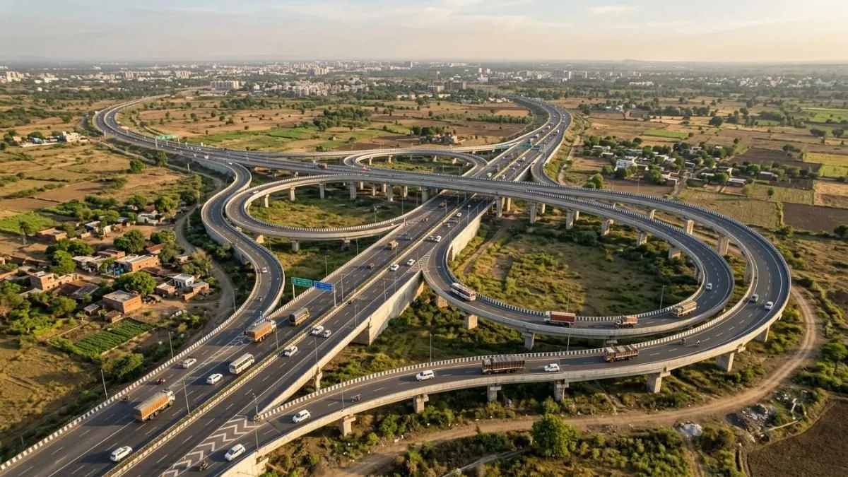
2. Project Overview and Technical Specifications
The sheer scale of the Golden Arch places it among the most significant infrastructure undertakings in Maharashtra. Managed by the NMRDA, the project is characterized by its massive footprint and high capital expenditure.
Key Project Details at a Glance
| Feature | Specification |
|---|---|
| Project Name | New Outer Ring Road Nagpur (Third Ring Road / Golden Arch) |
| Implementing Authority | Nagpur Metropolitan Region Development Authority (NMRDA) |
| Total Planned Length | Approximately 148 Kilometers |
| Estimated Project Cost | Rs 13,748 Crore |
| Proposed Right of Way (Width) | 120 Meters |
| Land Requirement | Approximately 1,697 Hectares |
| Villages Impacted | 99 Villages across the Metropolitan Region |
| Primary Objective | Logistics efficiency, bypass for interstate freight, and regional expansion |
The 120-meter width is particularly noteworthy. This allows for not just a multi-lane expressway but also provides provisions for service roads, green belts, and potentially future utility corridors (such as pipelines or fiber optics), making it a multi-modal infrastructure asset.
3. Mapping the ‘Golden Arch’: Route and Connectivity
The proposed route of the 148-km corridor is designed to intersect every major highway radiating from Nagpur. This "hub-and-spoke" connectivity ensures that vehicles coming from any direction can bypass the city center entirely.
Strategic Intersections
The Golden Arch is expected to provide seamless linkages to:

- The Samruddhi Mahamarg (Nagpur-Mumbai Expressway): Enhancing the flow of goods toward India’s financial capital and the JNPT port.
- NH-44 (North-South Corridor): Connecting Srinagar to Kanyakumari.
- NH-53 (East-West Highway): Linking Surat to Kolkata.
- Amravati Road & Wardha Road: Two of the busiest industrial and residential arteries in the region.
- Jabalpur and Chhindwara Routes: Facilitating trade with Central and Northern India.
Proposed Transport Hubs
To maximize the utility of the ring road, planners have identified specific locations for integrated transport hubs. These include:
- Gumgaon
- Jamtha
- Kapsi
- Asoli
These hubs will serve as staging areas for trucks, warehouses, and cold storage facilities, effectively moving the "chaos" of the logistics industry away from residential neighborhoods and into organized, high-access zones.
4. Chronology: From Concept to Land Acquisition
The evolution of Nagpur’s road network has followed a distinct pattern of outward expansion:
- The Internal Ring Road: Constructed decades ago to manage traffic within the city’s core.
- The Second Ring Road (Current Outer Ring Road): A 60-km stretch that is currently operational. While it initially served as a bypass, the rapid growth of areas like Besa, Pipla, and Wadi has turned it into a semi-urban road.
- The 2023-2024 Planning Phase: Recognizing that the Second Ring Road would soon be overwhelmed, the NMRDA formalized the 148-km Golden Arch plan.
- Current Status (2024-2025): The project is currently in the critical stage of land acquisition and environmental clearance. A total of 1,697 hectares must be acquired from 99 villages. Given the scale, the state government is looking at various funding models, including potential partnerships with the National Highways Authority of India (NHAI).
Officials indicate that the project will likely be executed in phases. The initial focus will be on the stretches that connect the Samruddhi Mahamarg with major industrial clusters to provide immediate economic relief.
5. Official Responses and Strategic Importance
Government officials and urban planners view the New Outer Ring Road as the "backbone" of the future Vidarbha economy. In recent statements, representatives from the NMRDA have emphasized that this project is not just about transit, but about Transit-Oriented Development (TOD).
"Nagpur is naturally positioned to be the logistics capital of India," says an urban planning consultant associated with regional projects. "However, geography alone isn’t enough. You need the infrastructure to support it. The Golden Arch provides the 120-meter wide ‘breathing room’ the city needs to grow without suffocating its residents with heavy traffic."
The project also aligns with the State Government’s vision to transform Vidarbha by 2028. By integrating the ring road with the four new expressways recently approved for Maharashtra, Nagpur will become the most connected city in Central India.
6. Economic and Real Estate Implications
Infrastructure on this scale inevitably alters the real estate landscape. For Nagpur, the New Outer Ring Road is expected to trigger a shift in property demand from the city center to the far peripheries.
Industrial and Logistics Growth
The areas surrounding the 99 villages covered by the project are poised to become "Logistics Goldmines." With the 120-meter width allowing for easy movement of oversized cargo, industries such as e-commerce fulfillment centers, manufacturing units, and agro-processing plants are expected to flock to this corridor.
Residential Expansion
As the ring road improves connectivity, the "commutable distance" from the city center increases. We are likely to see:
- Township Projects: Large-scale residential developments offering "resort-style" living away from city noise.
- Plotted Developments: A surge in demand for investment plots in areas like Maa Umiya Dham and regions near the Wardha Road intersection.
- Appreciation in Land Value: Historical data suggests that land prices near major ring roads in cities like Hyderabad and Ahmedabad saw a 3x to 5x increase within a decade of project announcement. Nagpur is expected to follow a similar trajectory.
Impact on MIHAN
The Multi-modal International Cargo Hub and Airport at Nagpur (MIHAN) stands to be one of the biggest beneficiaries. Better road connectivity means faster "last-mile" delivery for air cargo, making the Special Economic Zone (SEZ) even more attractive to global tech and aviation firms.
7. Challenges and the Road Ahead
Despite the optimism, a project of this magnitude faces significant hurdles:
- Land Acquisition: Negotiating with landowners across 99 villages is a complex administrative task. Ensuring fair compensation while maintaining the project timeline remains a challenge.
- Funding: With an estimated cost of nearly Rs 14,000 crore, securing consistent funding through state and central allocations is vital.
- Environmental Impact: Constructing a 148-km loop requires careful environmental management to ensure that local water bodies and green cover are preserved.
8. Conclusion: Shaping the Nagpur of 2050
The New Outer Ring Road, or the Golden Arch, is more than just a infrastructure project; it is a blueprint for Nagpur’s future. While the existing bypasses serve the needs of today, this 148-km corridor is being built for the needs of 2050.
By separating local traffic from national freight, providing a dedicated corridor for industrial growth, and opening up thousands of hectares for planned urban development, the NMRDA is ensuring that Nagpur remains a livable, efficient, and economically vibrant city. For investors, residents, and logistics players, the Golden Arch represents the next great frontier in the evolution of Maharashtra’s third-largest city.
As land acquisition progresses and the first phases of construction begin, all eyes will be on this 148-km loop to see how it steers the "Orange City" toward its destiny as a global metropolis.
Disclaimer: This report is based on current planning documents, industry reports, and available government data. Infrastructure projects of this scale are subject to changes in route, budget, and timelines based on administrative decisions and ground realities. Readers are advised to verify specific details with the NMRDA or relevant authorities before making investment decisions.
