

KOLKATA — Beneath the modern landscape of Central India, hidden under layers of soil and vegetation, lies a silent geological diary that spans over a billion years. A groundbreaking study by a collaborative team of geologists from the Indian Statistical Institute (ISI) and the Geological Survey of India (GSI) has recently deciphered this ancient record, revealing a dramatic saga of tectonic violence and oceanic tranquility.
The research provides a comprehensive mapping of the Chhattisgarh Basin, a massive geological feature located within the Bastar Craton. The study traces the region’s evolution from its origins as a jagged, catastrophic rift in the Earth’s crust roughly 1.4 billion years ago to its maturation into a stable, shallow prehistoric sea. This transformation offers more than just a local history; it provides a rare window into the Mesoproterozoic era—a pivotal but often mysterious period of Earth’s "middle history" that shaped the very architecture of our modern continents.
Main Facts: A Geological Masterpiece in the Bastar Craton
The Chhattisgarh Basin is one of the largest Proterozoic sedimentary basins in India, yet its origins have long been a subject of intense academic debate. For decades, geologists have grappled with the question of how this vast depression formed and what environmental forces filled it with hundreds of meters of sediment.
The new findings, published by researchers in Kolkata, confirm that the basin’s story began during the Mesoproterozoic era (1,600 to 1,000 million years ago). This was a time long before the emergence of complex life, plants, or even the familiar arrangement of the world’s landmasses. Instead, the Earth was characterized by the "Supercontinent Cycle," where massive landmasses periodically collided and tore themselves apart.
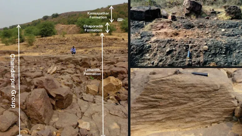
The study focused on the Chandarpur Group, a sequence of sedimentary rocks approximately 450 meters thick. By meticulously analyzing these rocks—ranging from coarse conglomerates to fine shales—the team reconstructed a timeline of environmental change. Their work proves that the basin was not a static feature but a dynamic entity that responded to the rhythmic pulses of the Earth’s tectonic plates.

Chronology of a Basin: From Violent Rifting to Serene Seas
The evolution of the Chhattisgarh Basin can be divided into three distinct chapters, each recorded in a specific layer of the Chandarpur Group.
Chapter I: The Great Rift (The Lohardih Formation)
The story begins approximately 1.4 billion years ago with a process known as intracratonic rifting. The Earth’s crust beneath the Bastar Craton began to stretch and pull apart, likely due to mantle plumes or tectonic stresses associated with the breakup of the supercontinent Columbia.
As the crust thinned and cracked, the ground subsided, creating a deep, jagged valley. The researchers found evidence of this era in the Lohardih Formation, the lowermost layer of the basin. This layer is characterized by "alluvial fans"—steep, wedge-shaped deposits of gravel and debris. These rocks are poorly sorted and coarse-grained, suggesting they were deposited by high-energy, flash-flood events in a semi-arid climate. At this stage, the Chhattisgarh Basin was a violent, terrestrial landscape of steep cliffs and rushing torrents.
Chapter II: The Marine Incursion (The Chaporadih Formation)
As millions of years passed, the initial tectonic violence began to subside. The crust stabilized, and the basin continued to sink and widen. This subsidence eventually allowed the prehistoric ocean to breach the basin’s edges, flowing in from the north-northwest.
The transition is captured in the Chaporadih Formation. Here, the coarse gravels of the rift valley give way to fine-grained silts and shales. This shift indicates a deepening of the environment, where the turbulent rivers were replaced by a quiet, marine setting. In these calm waters, fine mud settled slowly over eons, preserving a record of a "passive-margin" basin—an environment similar to the modern-day Atlantic coastlines, where the edge of a continent meets the sea without active volcanic or tectonic upheaval.

Chapter III: The Epicontinental Sea (The Kansapathar Formation)
The final stage of the basin’s early history is written in the Kansapathar sandstones. These rocks are "mature quartzarenites"—exceptionally pure, well-washed sandstones that only form in environments where sediment has been tumbled and cleaned by waves for vast periods.
By this era, the basin had become an epicontinental sea. Unlike the deep open ocean, this was a shallow sea that sat directly atop the continental crust. The researchers identified "hummocky cross-stratification" within these rocks—a specific geological pattern that points to a coastline frequently lashed by massive prehistoric storms and shaped by powerful tidal cycles. The basin had reached a state of geological maturity, serving as a stable marine shelf for hundreds of millions of years.
Supporting Data: Reading the Language of Stone
To reach these conclusions, the ISI and GSI researchers employed a rigorous methodology known as facies analysis. This involves looking at the "personality" of a rock layer to determine its origin.
- Grain Size and Sorting: The transition from the "poorly sorted" (mixed sizes) rocks of the Lohardih Formation to the "well-sorted" (uniform size) sandstones of the Kansapathar Formation provided the primary evidence for the shift from land-based floods to sea-based wave action.
- Mineral Chemistry: The high purity of the quartz in the upper layers indicates a "tectonically quiescent" period. In simpler terms, the Earth’s crust had stopped shaking long enough for weathering and waves to strip away all minerals except the hardest quartz.
- Ripple Patterns: The team examined fossilized ripple marks and cross-bedding (angled layers within the rock). These patterns acted as a compass, showing that the ancient waters flowed and ebbed in ways consistent with a shallow, storm-dominated sea.
This data-driven approach allowed the team to create a "lithostratigraphic map," essentially a three-dimensional blueprint of how the basin’s floor changed in response to the Earth’s internal heat and external climate.
Official Responses and Scientific Context
The findings have significant implications for the broader scientific community, particularly in the ongoing debate regarding the classification of Indian sedimentary basins.

Previously, some geologists argued that the Chhattisgarh Basin was a foreland basin. A foreland basin is created when the weight of a growing mountain range pushes down on the adjacent crust (much like how the Himalayas created the Ganga basin). However, the ISI/GSI study challenges this.
"By linking the sedimentary layers directly to tectonic pulses, our work confirms the rift-to-sea model," the researchers noted in their report. They argue that the basin’s birth and evolution align perfectly with the Wilson Cycle—the cyclical opening and closing of ocean basins. Specifically, the basin’s formation matches the timeline of the breakup of the supercontinent Columbia and the subsequent drift that eventually led to the assembly of the supercontinent Rodinia.
Experts in Indian stratigraphy have welcomed the study, noting that it provides the first "complete history" of the region. By moving away from speculative models and focusing on the hard evidence of facies analysis, the team has provided a definitive framework for future exploration.
Implications: Why a Billion-Year-Old Basin Matters Today
While the study of 1.4-billion-year-old rocks may seem academic, its implications stretch into the modern day and the future.
1. Understanding Crustal Stability
By mapping how the Earth’s crust reacted to ancient stresses, scientists can better understand the long-term stability of the Indian subcontinent. The Bastar Craton is one of the "anchors" of the Indian plate; understanding how its edges rifted and healed helps geophysicists predict how the plate might respond to modern tectonic pressures.

2. Resource Exploration
Sedimentary basins like the Chhattisgarh are often primary targets for mineral and resource exploration. While this specific study focused on geological history, the identification of mature sandstones and specific shale layers provides vital data for those looking for groundwater aquifers or mineral deposits. Mature quartzarenites, for instance, are often associated with high-quality industrial silica.
3. Future Research Frontiers
The researchers were quick to point out the challenges that remain. Over a billion years, erosion has erased much of the geological record. "One major limitation is the absence of continuous outcrops," the team stated. Much of the evidence is buried under younger soil or has been worn away by the monsoons of the last few million years.
To overcome this, the next phase of research will likely move from the surface to the subsurface. The scientists have called for the use of geophysical tools, such as seismic and gravity surveys. These technologies will allow geologists to "see" through the earth, mapping the deep structures of the rift that remain hidden from the naked eye.
Conclusion
The Chhattisgarh Basin is more than just a geographic region in Central India; it is a monument to the Earth’s resilience. From a violent crack in the world to a peaceful, storm-swept sea, its 1.4-billion-year journey reminds us that the ground beneath our feet is a living, changing entity.
As we look toward a future of shifting climates and tectonic movement, the lessons learned from the Mesoproterozoic rocks of the Bastar Craton provide a vital perspective. They remind us that while the Earth may break, it also heals, slowly transforming the scars of tectonic rifts into the foundations of stable continents.
