

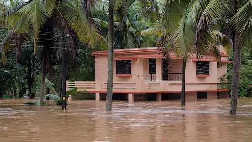
In an era where the climate crisis is no longer a distant threat but a seasonal reality, the unpredictability of the Indian monsoon has become a primary concern for policymakers and disaster management teams. Each year, devastating floods claim lives, destroy infrastructure, and displace thousands across the Indian subcontinent. The vulnerability of India’s long coastline and the ecologically sensitive Western Ghats has long demanded a more sophisticated approach to disaster preparedness.
Responding to this urgent need, researchers at the Indian Institute of Technology (IIT) Bombay have unveiled a groundbreaking "double-barreled" artificial intelligence (AI) system. This technology is designed to predict not only where the next major flood will strike but also the precise depth to which the waters will rise. By integrating satellite radar data with advanced machine learning algorithms, the team has developed a high-resolution mapping system that identifies flood-prone zones with an unprecedented accuracy of over 93%.
I. Main Facts: A New Frontier in Hydrological Intelligence
The research, led by Dr. Kashish Sadhwani and Professor T.I. Eldho from the Department of Civil Engineering at IIT Bombay, marks a significant departure from traditional flood forecasting. The system covers a massive 55,000-square-kilometer corridor, stretching from Tadri in the Uttara Kannada district of Karnataka down to Kanyakumari at the southernmost tip of the Indian peninsula.
The Double-Barreled Approach
The core of this innovation lies in its "double-barreled" architecture, which utilizes a two-step machine learning process:
- The Classification Model: This first layer acts as a gatekeeper, analyzing topographical and environmental data to determine whether a specific area is at risk of flooding.
- The Regression Model: Once an area is identified as "at risk," this second layer calculates the estimated depth of the inundation. This allows for the creation of a continuous, three-dimensional map of potential flood scenarios.
Satellite Integration
Unlike traditional optical satellites, which are often blinded by the very clouds that cause floods, the IIT Bombay team utilized the European Space Agency’s (ESA) Sentinel-1 Synthetic Aperture Radar (SAR). SAR technology is capable of penetrating thick monsoon cloud cover and operating at night, providing a reliable stream of data regardless of weather conditions. By analyzing the "backscatter" signals—where water appears as dark patches on radar images due to its smooth surface—the AI was trained to recognize the signature of standing water with high precision.
High-Resolution Output
The system generates mapping down to a 30-meter grid resolution. In practical terms, this means local authorities can look at a digital map and identify specific landmarks—such as hospitals, schools, or arterial roads—that are likely to be submerged during a heavy rainfall event.
II. Chronology: From Historical Data to Real-Time Pattern Recognition
The development of this AI system reflects a shift in the philosophy of flood management. For decades, India relied on a combination of historical rainfall records and physical sensors (rain gauges) placed in rivers. However, these methods often failed to account for the complex interplay of modern land use, soil saturation, and rapid urbanization.
The Shift to Pattern Recognition
The IIT Bombay team began by moving away from simple rainfall-to-flood correlations. They recognized that while rainfall is the catalyst, it is not the sole determinant of a flood. Over several years of research, they curated a dataset that included satellite imagery from past major flood events in Karnataka and Kerala.
By comparing "before" and "during" images of historical floods, the researchers taught the AI to recognize patterns. The model was fed various "conditioning factors," including elevation, slope, land cover, and soil types. The goal was to move from a "reactive" model—where sensors tell you the river is already rising—to a "predictive" model that anticipates the landscape’s response to an incoming storm.
Identifying the Key Driver: Surface Runoff
A pivotal moment in the study occurred when the researchers discovered that surface runoff was a more critical predictor than the sheer volume of rainfall. This finding, published in a recent study, changed the way the model weighted its variables. The team spent months calibrating the AI to understand how different terrains—from the clay-heavy soils of Kerala to the steep slopes of the Western Ghats—processed water.
III. Supporting Data: Accuracy, Geography, and Technical Constraints
The effectiveness of any AI system is measured by its data integrity. The IIT Bombay study provides a robust set of metrics that highlight both the system’s power and its current boundaries.
Performance Metrics
- Accuracy: The classification model achieved a 93% success rate in identifying flood-prone zones.
- RMSE (Root Mean Square Error): The regression model, which predicts depth, currently operates with an error margin of approximately 0.99 meters.
- Resolution: A 30-meter grid, allowing for localized "micro-mapping" of disaster zones.
Geographical Focus
The study focused on the southern portion of the Western Ghats and the coastal plains of Karnataka and Kerala. This region is a "perfect storm" for flooding due to:
- Soil Composition: The prevalence of clayey soils, which have low infiltration rates, meaning water stays on the surface longer.
- Topography: Low-lying coastal plains that act as natural basins for runoff coming from the mountains.
- Slope Constraints: The current model is optimized for terrains with a slope of less than 7%. This is a deliberate choice; in steeper areas, radar signals suffer from "layover" and "shadowing" effects, where the mountain itself blocks the radar’s view of the water. Furthermore, water on steep slopes moves too quickly for current SAR capture cycles to map accurately.
The Runoff Factor
The study emphasizes that rainfall intensity (mm/hr) is only half the story. The AI prioritizes "Surface Runoff," which accounts for:
- Soil Moisture: Is the ground already soaked from previous days of rain?
- Infiltration Capacity: How much water can the ground actually absorb?
- Land Use: Is the water hitting a forest (high absorption) or a concrete parking lot (zero absorption)?
IV. Official Responses: Insights from the Researchers
Dr. Kashish Sadhwani, the lead researcher, has been vocal about the practical applications of this technology. According to Sadhwani, the system’s primary value is its ability to provide a regional overview at high speed.
"While rainfall is the primary driver of flood events, it does not directly translate into inundation at a given location," Dr. Sadhwani explains. "Surface runoff represents the integrated hydrological response of the landscape, capturing the combined effects of rainfall intensity, soil moisture, land use, and drainage characteristics."
Addressing the 0.99-meter error margin, Sadhwani notes that while a one-meter variation is significant for the ground floor of a building, the model’s current strength is its "breadth and speed." It is not yet a tool for individual homeowners to check if their doorstep will be wet, but it is an essential tool for regional commanders.
"The model is designed for rapid, regional-scale flood assessment," Sadhwani says. "This makes it particularly valuable for early-stage planning, prioritization of vulnerable zones, and emergency response support. It allows authorities to allocate resources effectively and prioritize regions for evacuation and relief efforts."
Professor T.I. Eldho, who co-authored the study, emphasized the methodology’s reliability. By restricting the flood depth calculations to areas with a slope of less than 7%, the team ensured that the data remains "physically consistent." This scientific rigor prevents the AI from making "hallucinations" or errors in steeper, more complex terrains where radar physics becomes unreliable.
V. Implications: Urban Planning and Future Scaling
The successful deployment of this AI framework has profound implications for the future of disaster management in India and beyond.
A Game-Changer for Local Governance
For states like Kerala, which has faced back-to-back catastrophic floods in recent years, this tool offers a roadmap for "climate-smart" urban planning. By knowing which 30-meter blocks are at highest risk, town planners can restrict the construction of critical infrastructure (like power substations or hospitals) in those zones, or ensure they are built on elevated platforms.
Scaling to the Megacities
The next frontier for the IIT Bombay team is the "complex urban hub." Scaling the model to cities like Mumbai or Chennai presents new challenges. Unlike the rural or semi-urban coastal plains of the current study, megacities are subject to:
- Tidal Fluctuations: High tides can prevent floodwaters from draining into the sea, causing "backflow."
- Storm Surges: Cyclonic activity can push seawater inland.
- Drainage Infrastructure: The AI must eventually account for man-made drainage systems, which are often clogged or undersized.
Dr. Sadhwani is optimistic about this transition. "Coastal environments introduce additional complexities. The methodology can be effectively adapted by incorporating these coastal-specific parameters into the existing framework," she notes.
Building National Resilience
As climate change increases the frequency of "extreme precipitation events," the traditional "wait and see" approach to monsoons is no longer viable. The IIT Bombay AI system represents a shift toward proactive resilience.
By providing a 93% accurate "early warning" map, the system gives the National Disaster Response Force (NDRF) a head start. Instead of deploying teams across an entire district, they can pinpoint the specific 30-meter grids where the water is expected to be deepest. This saves time, saves money, and, most importantly, saves lives.
In the long term, this research could form the backbone of a National Flood Forecasting System, one that uses the power of the "double-barrel" AI to protect the millions of citizens living on the front lines of the climate crisis. The work of Dr. Sadhwani and Professor Eldho is a testament to how Indian indigenous research is leading the way in using high-tech solutions to solve age-old environmental challenges.
