
SHIMLA – In the high-altitude reaches of the Himalayas, the landscape is shifting with a quiet, devastating speed. For decades, the massive glaciers of the "Third Pole" have served as the world’s largest freshwater repository outside the polar regions. Today, they are transforming from life-sustaining reservoirs into the architects of impending catastrophe. As global temperatures climb, the mountain state of Himachal Pradesh finds itself at the epicenter of a dual crisis: a rapidly melting cryosphere and a development model that places human habitation directly in the path of destruction.
Main Facts: The Anatomy of a High-Altitude Hazard
The crisis in the Himalayas is no longer a distant projection of climate models; it is a lived reality for downstream communities. According to recent glaciological findings, the Himalayas have lost an average of 27 meters of ice thickness since 1975. Most alarmingly, the rate of glacial retreat has doubled since the turn of the millennium.
While global warming is the primary driver—with the Himalayas warming at a rate significantly higher than the global average—the disaster risk is compounded by localized anthropogenic factors. Infrastructure development, tourism-driven construction, and the resulting emissions of black carbon and dust have lowered the albedo (reflectivity) of the ice, accelerating the melt.
![Climate resilience in Himachal begins with spatial planning [Commentary]](https://imgs.mongabay.com/wp-content/uploads/sites/30/2026/06/16161947/Image-1-2-1200x800.jpg)
This rapid melting has led to the formation of hundreds of new "proglacial" lakes—bodies of water held back by unstable dams of loose rock and ice debris (moraines). When these natural dams fail, they trigger a Glacial Lake Outburst Flood (GLOF). A GLOF is characterized by the sudden release of millions of cubic meters of water and debris, capable of traveling dozens of kilometers downstream with enough force to pulverize concrete bridges and erase entire villages.
The threat is no longer theoretical. In Himachal Pradesh, the number of glacial lakes has more than doubled in just six years, increasing from 2016 to 2022. For states like Himachal, this represents a fundamental shift in disaster profiles, moving from seasonal monsoon flooding to unpredictable, high-velocity cascading hazards.
Chronology: From Gradual Melt to Accelerated Catastrophe
The timeline of the Himalayan glacial crisis reveals a disturbing acceleration in both environmental degradation and the frequency of disasters:
- 1975–2000: A period of steady glacial retreat. Scientists note a loss of ice, but the formation of large proglacial lakes remains relatively limited.
- 2000–Present: Glacial loss rates double. The "warming hole" over the Himalayas begins to close, leading to unprecedented temperature spikes in high-altitude zones. GLOF events become more frequent and destructive across the Hindu Kush-Himalayan belt.
- 2013: The Kedarnath disaster in neighboring Uttarakhand serves as a grim harbinger. A GLOF event, triggered by intense rainfall and a breached moraine dam at the Chorabari Lake, claims nearly 6,000 lives and decimates the Mandakini Valley.
- 2016–2022: A critical period of lake formation in Himachal Pradesh. Satellite data reveals that in the Beas, Chenab, Ravi, and Satluj basins, the number of moraine-dammed lakes increases exponentially. In the Beas basin alone, the count jumps from 63 to 139.
- 2023: A catastrophic monsoon season in Himachal Pradesh results in 1,197 deaths and economic losses exceeding ₹16,000 crore. While heavy rain is the immediate trigger, the scale of the damage is amplified by the sheer volume of water coming from the glaciated headwaters and the debris-heavy flows of the Beas and Sutlej rivers.
- 2024: The Malana flash flood underscores the vulnerability of hydropower infrastructure. A dam failure during a flood event necessitates a heroic rescue of stranded workers, highlighting the lack of automated early warning systems.
- 2025: The Supreme Court of India intervenes, flagging Himachal Pradesh’s growing climate crisis and instructing the state government to develop a comprehensive action plan to mitigate ecological neglect and unregulated development.
Supporting Data: Quantifying the Risk
The scale of the threat is best understood through the lens of the "Risk Triangle": Hazard, Exposure, and Vulnerability.
![Climate resilience in Himachal begins with spatial planning [Commentary]](https://imgs.mongabay.com/wp-content/uploads/sites/30/2026/06/16162421/Mandakini-left-bank-broken-bridge-rudraprayag-sangam-g-1200x900.jpg)
1. Increasing Hazard:
Projections for the Beas basin are particularly sobering. Research indicates that potential glacial lakes in this basin may soon contain the highest volume of water in the state. The probability of a GLOF event in the Kullu Valley is estimated to increase seven-fold in the coming decades due to the sheer volume of meltwater accumulating at high altitudes.
2. Growing Exposure:
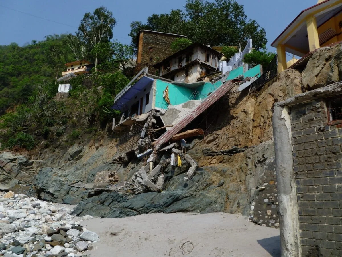
While Lahaul and Spiti districts have the highest physical risk of GLOF occurrence due to their proximity to glaciers, the "disaster risk" is actually higher in districts like Chamba, Kinnaur, and Kullu. This is because these regions have higher population densities. In the Kullu Valley, the expansion of the four-lane national highway has been followed by a surge in riverside construction. Markets, hotels, and public utilities now hug the banks of the Beas, placing thousands of people in the direct "inundation zone" of any potential GLOF.
3. Economic Vulnerability:
Himachal Pradesh is currently a debt-stressed state, making the ₹16,000 crore damage from the 2023 floods an almost insurmountable blow to its economy. The cost of rebuilding infrastructure—only for it to be at risk again—creates a cycle of "maladaptation" where resources are spent on temporary fixes rather than long-term resilience.
Official Responses: Planning Gaps and Judicial Intervention
The official response to the GLOF threat has been characterized by a disconnect between high-level policy and ground-level execution. While the state’s development plans for regions like Kullu and Shimla acknowledge environmental concerns, they often lack the "spatial teeth" required to enforce safety.
![Climate resilience in Himachal begins with spatial planning [Commentary]](https://imgs.mongabay.com/wp-content/uploads/sites/30/2026/06/16162750/Image-3-768x512.jpg)
The Spatial Planning Deficit:
Current development plans often restrict construction beyond the "high-flood level" of rivers. However, in many valleys, these levels have never been clearly demarcated or mapped using modern hydraulic modeling. Without a comprehensive flood zonation study, "high-flood level" remains a vague term that developers frequently bypass. Furthermore, hazard layers—which would show areas prone to landslides or GLOF paths—are conspicuously absent from the state’s spatial analysis maps.
Judicial Mandate:
The 2025 Supreme Court intervention marked a turning point. The Court criticized the "ecological neglect" and "unregulated development" that have come to define Himalayan urbanism. By instructing the government to create a climate action plan, the judiciary has forced a reckoning with the fact that "natural" disasters are often the result of human policy failures.
The Technology Gap:
While the state has invested in some technological monitoring, the coverage is sparse. Many glacial lakes remain unmonitored by real-time sensors, and the communication chain for early warning systems often breaks down before reaching the most vulnerable "last-mile" communities.
Implications: Redefining "Natural" Disasters and Building Resilience
The unfolding crisis in the Western Himalayas compels a fundamental question: Is a disaster truly "natural" if we choose to build in its path?
![Climate resilience in Himachal begins with spatial planning [Commentary]](https://imgs.mongabay.com/wp-content/uploads/sites/30/2026/06/16163218/Kullu_Townscape_with_River_Beas_-_Kullu_-_Himachal_Pradesh_-_2014-05-09_2196-768x512.jpg)
The Social Construction of Disaster:
The disasters in Dharali (Uttarakhand), Kullu (Himachal), and Chositi (Jammu and Kashmir) demonstrate that hazards only become disasters when they intersect with human vulnerability. Muck dumping from road construction, deforestation of steep slopes, and the narrowing of river channels for hotels are decisions made by planners and developers. These actions convert a manageable hazard into a lethal disaster.
The Power of Community Agency:
In the absence of robust state-led early warning systems, the role of frontline communities has become paramount. The story of Chhape Ram Negi during the 2024 Malana flash flood is a prime example. By self-organizing and alerting downstream communities of a dam failure, local residents saved lives that technology failed to protect. This suggests that resilience cannot be top-down; it must be built on the agency and traditional knowledge of those who live in the mountains.
The Path Forward: Spatial Governance:
To survive the GLOF era, Himachal Pradesh must adopt a new paradigm of "Spatial Governance." This includes:
- Participatory Risk Mapping: Engaging locals to identify historical flood paths and high-risk zones that satellite data might miss.
- Mandatory No-Build Zones: Clearly demarcated, legally enforced buffers along river corridors where no permanent infrastructure is permitted.
- Integrated Alert Systems: Combining high-tech satellite monitoring with low-tech community-led sirens and communication networks.
- Ecological Restoration: Moving away from "hard" engineering (concrete walls) toward "soft" engineering, such as reforestation and maintaining natural floodplains to absorb energy from debris flows.
Conclusion
The melting glaciers of Himachal Pradesh are a clarion call for a new relationship with the Himalayan landscape. As the "Water Tower of Asia" begins to leak, the state can no longer afford the luxury of unregulated growth. Resilience in the face of the GLOF threat will not be found in bigger dams or higher walls, but in the wisdom to step back from the river’s edge and the courage to integrate community knowledge into the heart of urban planning. For the people of the Himalayas, the ice is not just melting; it is speaking. It is time for the world to listen.
