KARAIKKAL, PUDUCHERRY – From a satellite’s perspective, the fish drying center at Arikampettai in the Karaikkal district of Puducherry appears as nothing more than an indistinct smudge on a thin strip of concrete. To the uninitiated eye looking at a digital map, the bamboo structures and blue tarpaulin sheets are noise in the data. However, on the ground, this patch of land is the beating heart of a local economy.
For the women of Akkampettai, Kilinjalmedu, and Karaikalmedu, these coastal "commons" are the difference between subsistence and poverty. They are the sites where fish are processed and dried for market. For the men, they are essential staging grounds for parking boats, mending nets, and repairing engines. For the children, they are the only playgrounds they have ever known.
Yet, a brewing crisis in India’s coastal governance threatens to render these vital spaces legally invisible. As the government drafts the new Coastal Zone Management Plans (CZMP) under the Coastal Regulation Zone (CRZ) Notification of 2019, a massive disconnect has emerged between the high-resolution reality of coastal life and the low-resolution maps used to govern it.
Main Facts: The Invisibility of the Commons
The central conflict lies in the scale and methodology of the Coastal Zone Management Plans. These maps are the primary legal documents used to determine what can and cannot be built along India’s 7,500-kilometer coastline. Under the CRZ Notification of 2019, the coast is divided into four primary zones:
- CRZ-I: Ecologically sensitive areas (mangroves, coral reefs).
- CRZ-II: Developed areas within municipal limits.
- CRZ-III: Relatively undisturbed rural areas.
- CRZ-IV: The water area from the Low Tide Line to 12 nautical miles seaward.
The "Coastal Commons"—land traditionally used by fishing communities for livelihood activities—fall squarely within these zones. However, the official CZMP maps are often drawn at a scale of 1:25,000. At this resolution, a single grid on the map can span nearly 196 square kilometers.
When mapping occurs at such a macro level, the micro-details of human existence—the 50-meter-wide fish drying yard, the community net-mending shed, or the sacred grove near the shore—disappear. For the fishing communities of Puducherry, this cartographic "silence" is not merely a technical error; it is an existential threat. If a fish drying yard is not marked on the official map, it does not legally exist. If it does not exist, it cannot be protected from future industrial development, tourism projects, or infrastructure expansions.
Chronology: The Evolution of Coastal Governance
To understand the current tension in Karaikkal, one must look at the history of coastal regulation in India, which has been a tug-of-war between environmental protection, industrial growth, and traditional rights.
- 1991: The first CRZ Notification is issued under the Environment Protection Act (1986). It recognizes the need to regulate activities near the shoreline but is criticized for being too rigid and failing to account for the needs of traditional dwellers.
- 2004: The Indian Ocean Tsunami devastates coastal villages, including those in Puducherry. The disaster highlights the vulnerability of coastal communities and the need for better buffer zones, but also triggers a push for "reconstruction" that often ignores traditional land use.
- 2011: A new CRZ Notification is released. For the first time, it explicitly mentions the need to map "fishing villages" and "common areas" used by the community. However, implementation is slow, and many states fail to complete their CZMPs for years.
- 2018-2019: The Ministry of Environment, Forest and Climate Change (MoEFCC) introduces the 2019 CRZ Notification. While it aims to streamline permissions for tourism and infrastructure, critics argue it dilutes protections for the environment and shifts the focus away from community-led conservation.
- 2022-2024: States and Union Territories, including Puducherry, begin the process of updating their CZMPs to align with the 2019 notification. This involves public hearings where fishing communities in Karaikkal and elsewhere discover that their villages and drying yards are missing from the draft maps.
Supporting Data: The High Cost of Small-Scale Mapping
The technical disparity between official maps and reality is backed by startling data. Research by environmental groups and academic fellows, such as Shreya Raman at the Asian College of Journalism, suggests that the 1:25,000 scale is fundamentally inadequate for coastal management.
- Spatial Distortion: At a 1:25,000 scale, a line drawn with a 0.5mm pen on the map represents 12.5 meters on the ground. For a small fish drying unit or a boat landing site, such a margin of error can mean the difference between being inside a protected zone or being cleared for a luxury resort.
- The Economic Engine: In Puducherry alone, the marine fisheries sector contributes significantly to the regional GDP. There are over 40 fishing villages across the Union Territory. The "informal" economy of fish drying—largely managed by women—is estimated to support thousands of households. When these spaces are excluded from maps, the legal basis for providing these communities with government subsidies or insurance for storm damage is weakened.
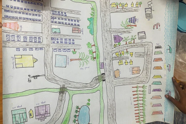
- Community Counter-Mapping: In response to the flawed official maps, villages in Karaikal have taken matters into their own hands. Using handheld GPS devices and smartphone apps, community members have geotagged hundreds of points of interest—drying yards, shrines, boat parking spots, and community halls. In some instances, community-made maps found over 60% more essential structures than the official government drafts.
Official Responses: The Bureaucratic Stance
The State Coastal Zone Management Authorities (SCZMA) and the National Centre for Sustainable Coastal Management (NCSCM) are the bodies responsible for drafting these plans. Their defense of the current mapping process usually centers on standardization and resource constraints.
Officials from the MoEFCC have previously stated that the 1:25,000 scale is a national standard intended to provide a broad framework for the entire country. They argue that local-level mapping (at 1:4,000 or 1:5,000 scale) is the responsibility of the state governments during the "local area plan" phase.

However, activists in Puducherry point out a "Catch-22" situation: the local area plans must be based on the broad CZMP. If the broad CZMP fails to recognize a fishing village, the local plan often follows suit.
During public consultations in Puducherry, officials have often been met with fierce resistance. In many sessions, community leaders have presented their own geotagged evidence, forcing officials to acknowledge that the draft maps were "incomplete." While some officials have promised to rectify the omissions, the final versions of the maps often remain opaque, leaving communities in a state of perpetual anxiety.
Implications: The Future of the Coast
The consequences of "erasing" these communities from the map extend far beyond a few lost fish drying yards. The implications are social, economic, and environmental.
1. Displacement and Privatization
When coastal commons are marked as "vacant land" or "undisturbed" in a CZMP, they become prime targets for land acquisition. Under the 2019 notification, certain restrictions on tourism infrastructure have been eased. Without legal recognition of their traditional use of the land, fishing communities have no standing to oppose the construction of hotels or private villas on the very spots where they currently mend their nets.
2. Marginalization of Women
The fish-drying sector is one of the few areas of the blue economy where women hold significant agency. By failing to map drying yards, the government is effectively making women’s labor invisible. This marginalization prevents women from accessing credit, improved technology, or social security benefits tied to their place of work.
3. Climate Vulnerability
The 2019 CRZ notification was supposed to help India prepare for sea-level rise. However, by ignoring the traditional knowledge of fishing communities—who know exactly how the tide has moved over decades—the maps fail to create an effective buffer. Fishing villages often act as the first line of defense against the sea; displacing them or replacing their flexible bamboo structures with rigid concrete infrastructure can exacerbate coastal erosion.
4. The Rise of Counter-Mapping as Resistance
The struggle in Karaikkal has birthed a new form of grassroots activism: Counter-mapping. By creating their own digital evidence, fishing communities are challenging the state’s monopoly on "truth." This movement suggests that for coastal management to be successful, it must be participatory.
"We are not against the maps," says a local fisherman from Kilinjalmedu. "We are against being left off them. If the map says we aren’t here, then the law says we don’t matter. We are mapping ourselves to prove we exist."
Conclusion: A Call for Participatory Cartography
The case of Arikampettai and the villages of Karaikkal serves as a cautionary tale for coastal governance worldwide. As nations rush to digitize and manage their natural resources, the "view from above" must be balanced with the "view from the ground."
For the Coastal Zone Management Plans to be truly effective, they must move beyond 1:25,000 scales and bureaucratic silos. They must incorporate community-generated data and recognize the coastal commons not as empty space, but as a vital socio-economic landscape. Until the blue tarpaulins and bamboo huts of Karaikkal are visible on the official maps, the lives and livelihoods of those who depend on them will remain in a state of precarious invisibility.