
KARAIKAL, PUDUCHERRY — Every morning at 1:00 a.m., while the rest of the Union Territory of Puducherry remains shrouded in sleep, 75-year-old Kannachiamma begins her workday. Her journey takes her eight kilometers to the Karaikal harbour, where she secures the day’s catch. By 4:00 a.m., she is back at a small, concretized patch of land near her village, meticulously cleaning, salting, and laying fish to dry under the rising sun.
For Kannachiamma, this 300-square-meter drying center on Mandapathur Road is not just a patch of concrete; it is her primary means of survival. On a productive day, she earns roughly ₹1,000 ($12 USD)—enough to keep her afloat. Yet, in the eyes of the Indian state’s latest coastal mapping exercises, Kannachiamma’s livelihood, and the very ground she stands on, are effectively invisible.
This erasure is not an accident of geography, but a consequence of cartography. As India updates its Coastal Zone Management Plans (CZMP) under the 2019 Coastal Regulation Zone (CRZ) notification, a technical dispute over map scales has become a frontline in the battle for coastal rights. For the women of Akkampettai, Kilinjalmedu, and Karaikalmedu, the map is not just a drawing; it is a document that determines whether their ancestral workspaces will be protected or paved over for tourism and industry.

Main Facts: The Cartographic Conflict
The heart of the dispute lies in the Coastal Regulation Zone (CRZ) notification, a legal framework designed to protect fragile coastal ecosystems while regulating human activity within 500 meters of the high tide line. Under this notification, states and union territories must draft Coastal Zone Management Plans (CZMP) to categorize land into various protection zones.
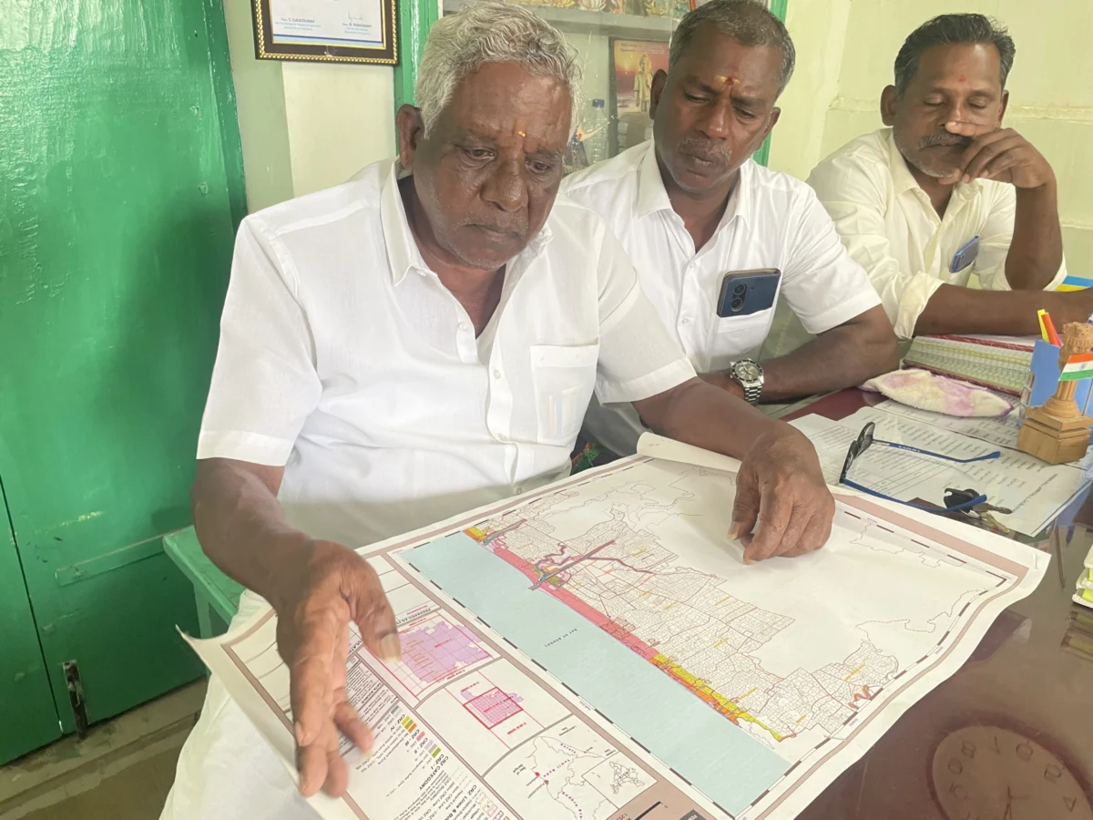
However, a significant technical hurdle has emerged: the scale of the maps. The central government mandates that CZMPs be drawn at a scale of 1:25,000. At this resolution, a single grid on the map covers nearly 196 square kilometers. For small-scale fishers, this scale is disastrously imprecise. Vital community "commons"—fish-drying yards, net-mending sheds, boat parking areas, and shrines—are too small to appear.
The primary concerns are:

- Scale Disparity: The 1:25,000 scale renders local infrastructure invisible, preventing meaningful public consultation.
- Exclusion of Commons: Fishing villages and their communal workspaces are frequently omitted from draft maps, leaving them vulnerable to "reclassification" for industrial or tourism use.
- Ecological Omission: Independent surveys suggest that up to 90% of eco-sensitive areas, including mangroves and sand dunes, are missing from official data provided by the National Centre for Sustainable Coastal Management (NCSCM).
- Livelihood Threat: Nearly half of the women in Puducherry’s fishing villages depend on these drying centers. Without legal recognition in the CZMP, these areas have no protection against coastal development.
Chronology: A History of Marginalization
The struggle for inclusive coastal planning in Puducherry has spanned over a decade, marked by bureaucratic inertia and community resistance.
- 1991–2011: The original CRZ notification of 1991 was amended dozens of times, gradually shifting focus from environmental protection to facilitating industrial growth. The 2011 notification introduced more specific requirements for community involvement, but implementation remained patchy.
- 2018: During public hearings for the 2011 CRZ draft plans, fishing communities submitted 19 detailed representations highlighting errors. When the final plans were released, community leaders noted that almost none of their concerns had been incorporated.
- January 2019: The Ministry of Environment, Forest and Climate Change (MoEFCC) issued the 2019 CRZ notification. Critics, including environmental lawyer Zaman Ali, argue this version significantly diluted protections, shrinking "No Development Zones" and opening the coast to real estate and large-scale tourism.
- March 2023: The Puducherry government released a draft CZMP based on the 1:25,000 scale. The map failed to name fishing villages and marked large swathes of the Karaikal beach as "tourism zones." In response, fishing communities boycotted the public hearings, citing a total lack of trust in the process.
- July 2023–April 2024: Following the boycott, a rare collaboration occurred. Traditional fisher panchayats, community organizers, and government officials formed a team to manually map fishing villages. This led to a second draft in April 2024.
- May 2024–August 2025: Despite the collaborative effort, the April draft still excluded critical mangroves and turtle nesting sites. Resident M. Malayalathan approached the National Green Tribunal (NGT) to quash the maps. In August 2025, the NGT disposed of the case after the government promised to create a third, more inclusive draft.
- Present Day: Six months after the NGT ruling, community leaders report a total lack of communication from the Puducherry Pollution Control Committee (PPCC).
Supporting Data: The Coastline Paradox and Scale Math
The technical debate is rooted in a phenomenon known as the Coastline Paradox. This geographical theory states that the measured length of a coastline increases as the scale of measurement becomes finer. This is not merely academic; last year, India’s official coastline "increased" from 7,500 kilometers to 11,100 kilometers simply because the government moved from a 1:4,500,000 scale to a 1:250,000 scale.
The Scale Gap
The 1:25,000 scale required for CZMPs is 6.25 times less detailed than the 1:4,000 scale maps used for local land administration (cadastral maps).

- 1:25,000 Scale: Used for the official CZMP. One centimeter on the map equals 250 meters on the ground. A fish-drying yard of 20×15 meters becomes a microscopic dot.
- 1:4,000 Scale: Used for project clearances (hotels, ports). One centimeter equals 40 meters. At this scale, individual houses and drying patches are clearly visible.
Missing Ecology
A report by the Coastal Peoples’ Right to Life Movement (CPRM) in August 2024 utilized ecologists and GIS experts to audit the government’s data. They found that the official maps missed 70% to 90% of eco-sensitive areas in Puducherry and Karaikal, including over 1,200 acres of mangroves, sand dunes, and nesting grounds.
Coastal Erosion
The need for accurate mapping is heightened by climate change. Between 1990 and 2016, approximately 57% of Puducherry’s coast underwent significant erosion. In December 2025, the Ditwah cyclone wiped out rows of fishing nets in Veerampattinam, proving that the "coastline" is a fluid, receding boundary that current static maps fail to capture.
Official Responses: Administrative Impasse
The official stance from government bodies has been one of procedural adherence rather than community engagement.

The Puducherry Pollution Control Committee (PPCC) submitted a status report to the NGT claiming that all eco-sensitive areas had been marked. They argued that the 1:25,000 scale is a national mandate and that finer details are meant for "local level" maps to be created after the primary plan is approved.
However, environmental lawyer Zaman Ali points out a systemic double standard: "While communities are told they must wait for local maps, private project proponents—such as luxury hotels or ports—frequently hire the NCSCM to create specialized 1:4,000 scale maps for their specific project areas. These private maps are then used to ‘correct’ the official CZMP, often reclassifying protected intertidal zones (CRZ-IB) into less protected categories (CRZ-IIIB) to allow for construction."
When contacted for updates on the promised third draft, the Puducherry Coastal Zone Management Authority (PCZMA) remained silent. As of early 2026, the Union Territory continues to be governed by outdated 2011 plans, leaving current ecological and social realities unaddressed.

Implications: The High Cost of Invisibility
The failure to accurately map the coastal commons has profound implications for India’s 4 million-strong fishing population.
1. Structural Displacement
By failing to mark fishing villages and drying units on the primary CZMP, the state effectively classifies these lands as "vacant." This makes it structurally easy to divert the land for Special Economic Zones (SEZs), commercial ports, or high-end tourism. For fishers, the coast is "livelihood infrastructure"; for the state, it is "real estate."
2. Loss of Customary Rights
Most coastal communities operate on "customary rights"—centuries of tradition rather than paper deeds. The CRZ is the only legal framework that acknowledges these rights. If the maps do not reflect the usage of the land, the communities have no legal standing to contest their eviction when a new project is proposed.

3. Climate Vulnerability
With 57% of the coast eroding, communities need long-term housing plans further inland. Both the 2011 and 2019 notifications mandate that states provide housing plans for fishers. To date, no such plan has been integrated into the Puducherry CZMP. Activist Jesu Rathinam notes, "Land is being diverted for industry while the very people who protect the coast are left without a roof that won’t be claimed by the sea."
4. The Gendered Impact
The erasure of drying centers specifically targets women. While men dominate the deep-sea catch, women like Kannachiamma dominate the post-harvest economy. When drying yards disappear from the map, it is the economic independence of coastal women that is the first to be sacrificed.
As the sun sets over the Karaikal harbour, Kannachiamma packs her dried fish into a sack. She is unaware of the "Coastline Paradox" or the difference between a 1:25,000 and 1:4,000 scale map. She only knows that the concrete patch where she works is becoming harder to keep. In the world of high-level policy, if you are not on the map, you do not exist. For the fishing communities of Puducherry, the fight to be seen is a fight to survive.
