
BENGALURU, India – May 3, 2026 – In a monumental leap forward for India’s burgeoning space sector, the successful launch of Mission Drishti on Sunday has not only cemented the nation’s position as a high-tier global space power but has also heralded the dawn of a revolutionary hybrid space ecosystem. This new paradigm seamlessly integrates cutting-edge private innovation with critical national strategic goals, promising unprecedented advancements in Earth observation and beyond.
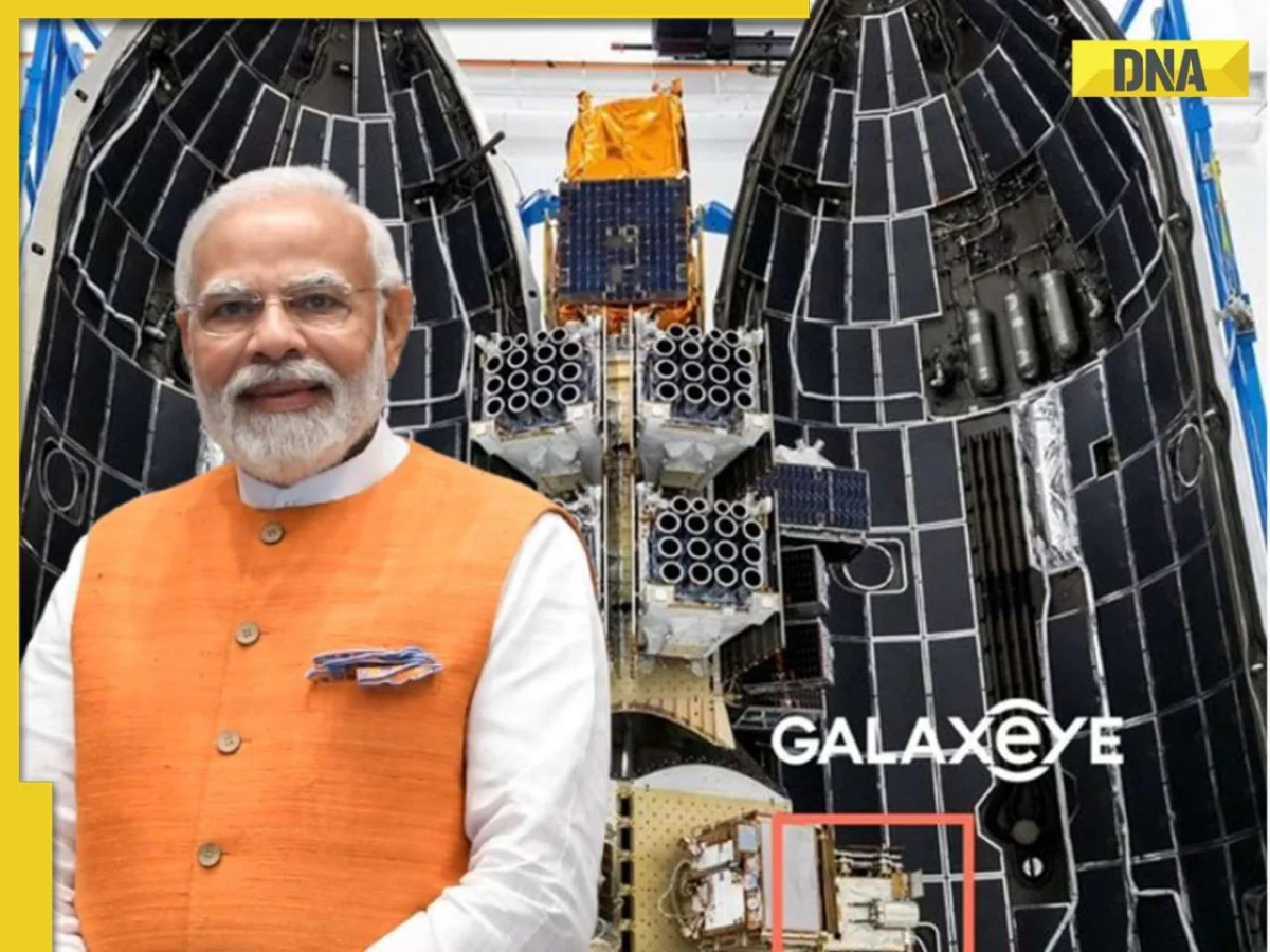
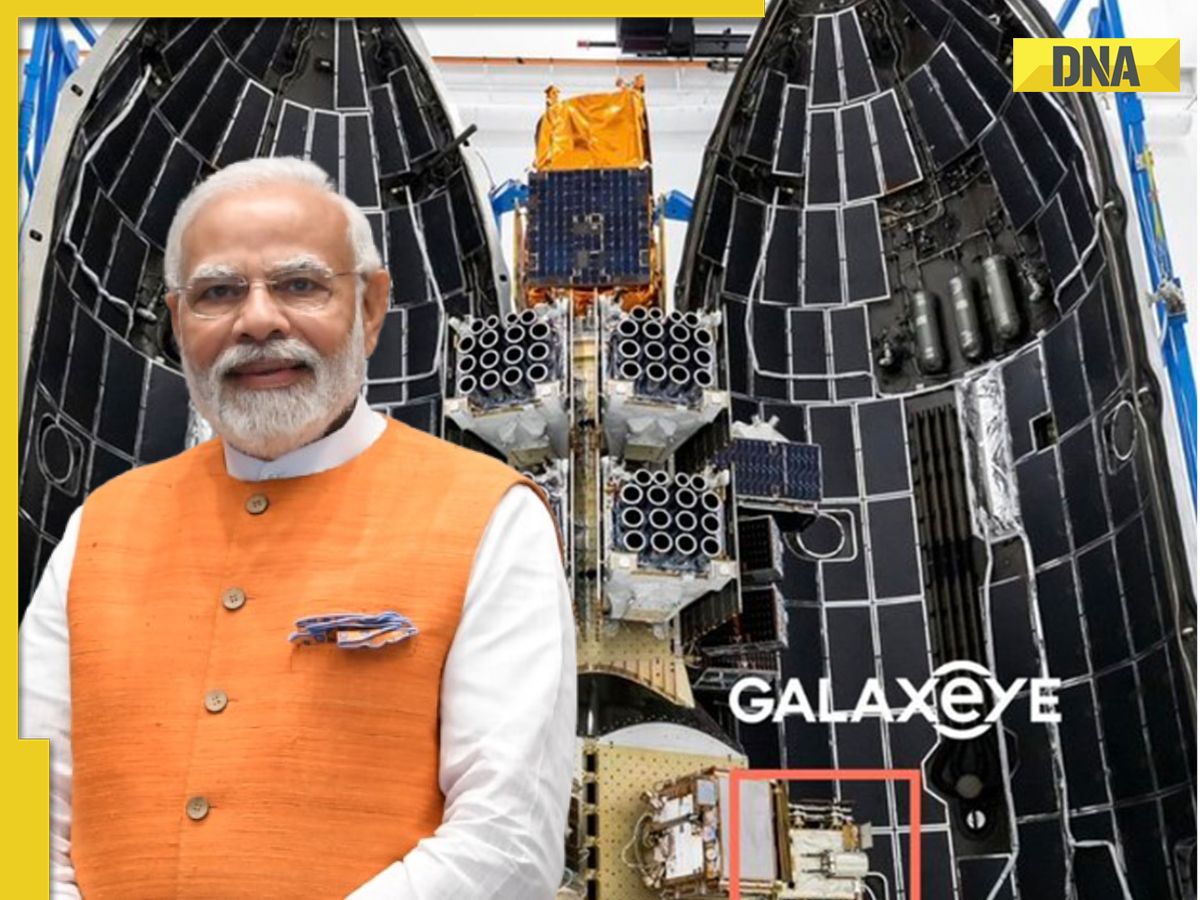
The mission’s centerpiece, a 190 kg satellite developed by Bengaluru-based startup GalaxEye, now proudly holds the distinction of being India’s largest privately built spacecraft to date. Its journey to orbit aboard a SpaceX Falcon-9 rocket from the Vandenberg Space Force Base in California, United States, marks a pivotal moment, showcasing the prowess of Indian enterprise on the global stage. This landmark achievement, celebrated across the nation, underscores a profound shift in India’s space narrative, where entrepreneurial spirit and government vision converge to push the boundaries of technological possibility.
The technical marvel at the heart of Mission Drishti is its OptoSAR technology – a world-first for a commercial satellite. This groundbreaking system transcends the limitations of traditional Earth imaging by fusing two distinct yet complementary technologies: Optical Sensors, which provide high-resolution, intuitive visual data, and Synthetic Aperture Radar (SAR), capable of penetrating clouds, smoke, and total darkness. This "made-in-India" innovation ensures all-weather, day-and-night imaging capabilities, promising a continuous stream of invaluable data for a myriad of applications, from environmental monitoring to disaster management and strategic intelligence.

The Genesis of a Vision: A Chronological Account of Mission Drishti
The journey of Mission Drishti from concept to orbital reality is a compelling narrative of ambition, innovation, and strategic collaboration. It represents the culmination of years of dedicated research, development, and a bold vision to redefine Earth observation.
Inception and Vision: GalaxEye’s Bold Beginnings
GalaxEye Space, a Bengaluru-based startup, emerged from the vibrant Indian deep-tech ecosystem with a clear and ambitious goal: to democratize access to comprehensive, all-weather Earth observation data. Founded by a team of young, dynamic engineers and visionaries, the company recognized a critical gap in existing satellite imaging capabilities – the inability to provide consistent, high-quality data irrespective of environmental conditions. Traditional optical satellites are often rendered useless by cloud cover, fog, or nightfall, while SAR systems, though powerful, lack the intuitive visual context of optical imagery. GalaxEye’s founders envisioned a solution that would combine the best of both worlds, leading to the conceptualization of OptoSAR technology.
The initial phases involved intensive research and development into sensor fusion techniques. The challenge was not merely to integrate two distinct technologies but to do so in a compact, efficient, and commercially viable package. This required breakthroughs in miniaturization, power management, and real-time data processing algorithms. Early funding rounds, both from domestic venture capitalists and government grants aimed at fostering the private space sector, provided the necessary impetus to transform these ambitious designs into tangible hardware.
)
Developing the OptoSAR Core: The "Made-in-India" Advantage
The development of the OptoSAR payload itself was a testament to India’s growing capabilities in advanced manufacturing and aerospace engineering. Engineers at GalaxEye worked meticulously on designing and fabricating the intricate sensor package. The optical component required precision optics and advanced image processing units to capture high-resolution visual data. Simultaneously, the SAR component demanded sophisticated radar antennae, transmitters, and receivers capable of emitting and interpreting microwave signals that could penetrate adverse weather conditions.
A significant aspect of this development was the emphasis on "made-in-India" components and expertise. This commitment not only aligned with national initiatives like "Atmanirbhar Bharat" (Self-Reliant India) but also ensured greater control over the supply chain, fostering indigenous technological growth and reducing reliance on foreign entities. The iterative design and testing phases involved simulating various atmospheric conditions and target scenarios to fine-tune the sensor’s performance, ensuring its ability to deliver on its promise of all-weather, day-and-night imaging. The 190 kg satellite, a formidable engineering feat for a private Indian entity, was assembled and rigorously tested in state-of-the-art facilities in Bengaluru, meeting stringent space-grade qualification standards.
The Alliance with SpaceX: A Global Launch Partner
With the satellite ready, the next critical step was its journey into orbit. Recognizing the efficiency and reliability of commercial launch services, GalaxEye forged a partnership with SpaceX, the pioneering American aerospace manufacturer and space transportation services company. The decision to launch aboard a Falcon-9 rocket from the Vandenberg Space Force Base in California underscored the global nature of modern space endeavors and the trust placed in established commercial launch providers.

The Falcon-9, known for its reusability and consistent success rate, provided a robust platform for Mission Drishti. The satellite was integrated as one of the 45 payloads on the CAS500-2 mission, a ride-share program that allows smaller satellites to reach orbit alongside larger primary payloads, making space access more affordable and frequent for private companies. This collaboration highlighted the growing trend of Indian startups leveraging global infrastructure to accelerate their space ambitions, while simultaneously showcasing India’s capabilities to a wider international audience.
Launch Day: A Flawless Ascent
Sunday, May 3, 2026, dawned with anticipation at the Vandenberg Space Force Base. The Falcon-9, a towering symbol of modern spaceflight, stood ready on its launchpad. As the countdown progressed, millions across India and the world watched with bated breath. At the precise moment, the rocket’s Merlin engines roared to life, generating immense thrust and illuminating the pre-dawn sky. The ascent was flawless, a testament to SpaceX’s engineering and the meticulous preparation by both launch and satellite teams.
Within minutes, the Falcon-9 cleared the atmosphere, shedding its first stage for a controlled landing, while the second stage continued its trajectory towards the designated orbital altitude. Finally, with precise timing, Mission Drishti was successfully deployed into its intended orbit. Telemetry data soon confirmed the satellite’s health, its solar panels deployed, and its systems operational. The cheers from the mission control centers, both at Vandenberg and at GalaxEye’s headquarters in Bengaluru, resonated with a profound sense of achievement, marking the successful culmination of years of tireless effort and a new beginning for Indian space exploration.
)
The Technological Marvel: Unpacking OptoSAR’s Capabilities
Mission Drishti’s true innovation lies in its OptoSAR technology, a paradigm shift in Earth observation. Unlike any commercial satellite before it, OptoSAR seamlessly integrates two distinct sensor types, overcoming inherent limitations and delivering unprecedented data fidelity.
Understanding Optical Sensors:
Optical sensors are essentially high-resolution cameras in space. They capture images by detecting reflected sunlight, providing data that is intuitively understandable, much like a photograph. These sensors are excellent for identifying features such as land use patterns, vegetation health, urban infrastructure, and surface changes with high spatial resolution. However, their fundamental limitation is their reliance on visible light. They are rendered ineffective by cloud cover, smoke from wildfires, fog, and, critically, the absence of sunlight during nighttime. This means that for significant portions of the Earth, particularly in monsoon seasons or at higher latitudes, optical data can be sparse or unavailable for extended periods.
Understanding Synthetic Aperture Radar (SAR):
SAR technology operates on a completely different principle. Instead of passively capturing reflected light, SAR satellites actively transmit microwave pulses towards the Earth’s surface and then record the echoes that bounce back. By processing these echoes, SAR can generate highly detailed images of the terrain. The key advantage of SAR is its ability to penetrate clouds, smoke, and even operate in total darkness, as microwaves are not hindered by atmospheric conditions or the absence of sunlight. This makes SAR invaluable for consistent monitoring, especially in regions prone to persistent cloud cover or for applications requiring continuous, round-the-clock surveillance. However, SAR imagery can be more complex to interpret than optical images, often requiring specialized expertise to extract meaningful information.
)
The Power of Fusion: OptoSAR’s Breakthrough:
GalaxEye’s OptoSAR technology overcomes the individual shortcomings of optical and SAR sensors by fusing their data in real-time. This isn’t merely about having two separate sensors on board; it’s about a sophisticated system that processes and combines their outputs to create a single, comprehensive, and information-rich image. The "real-time" aspect is crucial, as it ensures that the optical and SAR data correspond to the exact same location and moment, eliminating discrepancies that can arise from separate passes.
This fusion means that users receive an image that combines the intuitive visual detail of an optical sensor with the all-weather, day-and-night penetration capabilities of SAR. For instance, an image from OptoSAR could show a flooded area (identified by SAR’s ability to detect water bodies through clouds) with the added visual context of surrounding infrastructure (provided by the optical sensor), all in a single, coherent dataset. This capability is transformative, offering:
- Uninterrupted Monitoring: Continuous data acquisition regardless of weather or time of day.
- Enhanced Information Content: A richer, more complete picture of the Earth’s surface.
- Improved Accuracy: Cross-validation of data points from two different sensor types.
- Simplified Analysis: A fused dataset that is more comprehensive and easier for analysts to work with.
The development of this combined payload, and the algorithms necessary to process and fuse the data efficiently on board the satellite before transmission, represents a significant engineering and computational triumph. It positions GalaxEye and India at the forefront of multi-spectral Earth observation technology, setting a new global standard for commercial satellite imaging.
)
A Spectrum of Applications: Transforming Industries and Safeguarding the Planet
The advanced capabilities of Mission Drishti’s OptoSAR technology promise to revolutionize a wide array of sectors, offering actionable insights that were previously unattainable or highly inconsistent. The ability to provide continuous, all-weather, day-and-night Earth imaging opens up unprecedented possibilities.
1. Agriculture and Food Security:
OptoSAR can provide continuous monitoring of crop health, growth stages, and soil moisture levels, even under cloudy skies during monsoon seasons. This data is crucial for precision agriculture, enabling farmers to optimize irrigation, fertilizer application, and pest management. It can also aid in accurate yield prediction, crop insurance assessments, and early detection of agricultural distress, contributing significantly to national and global food security.
2. Disaster Management and Humanitarian Aid:
In the wake of natural disasters such as floods, hurricanes, earthquakes, and forest fires, rapid and accurate damage assessment is critical. OptoSAR’s ability to penetrate smoke and clouds allows for immediate mapping of affected areas, identification of impassable routes, and assessment of structural damage. This real-time information is vital for coordinating rescue efforts, deploying humanitarian aid, and planning recovery operations, greatly reducing response times and saving lives.
)
3. Environmental Monitoring and Climate Change Research:
The satellite will play a crucial role in tracking environmental changes. This includes monitoring deforestation, glacier melt, sea-level rise, urban sprawl, and changes in water bodies. Its continuous data stream will enable scientists to better understand the impacts of climate change, track pollution sources, and support conservation efforts. For instance, it can monitor illegal mining activities or oil spills in coastal waters, providing critical data for enforcement and environmental protection.
4. Urban Planning and Infrastructure Development:
For rapidly urbanizing nations like India, OptoSAR offers invaluable tools for sustainable urban planning. It can monitor city growth, infrastructure development, traffic patterns, and land-use changes with high precision. This data supports efficient resource allocation, smart city initiatives, and the planning of future developments, ensuring that growth is managed effectively and sustainably.
5. Maritime Surveillance and Oceanography:
OptoSAR can significantly enhance maritime domain awareness. It can track ship movements, detect illegal fishing activities, monitor shipping lanes, and identify potential threats in coastal and international waters, irrespective of weather conditions. For oceanography, it can contribute to studies of ocean currents, wave patterns, and ice conditions, aiding in navigation and climate research.
)
6. Defense, Security, and Strategic Intelligence:
While primarily a commercial satellite, the capabilities of OptoSAR hold immense strategic importance. Its all-weather, day-and-night imaging provides enhanced reconnaissance and surveillance capabilities, crucial for national security. It can monitor borders, track troop movements, assess infrastructure, and provide critical intelligence in areas often obscured by clouds or darkness, bolstering India’s defense posture and strategic autonomy.
The comprehensive data generated by Mission Drishti is set to become a vital resource for governments, businesses, researchers, and humanitarian organizations worldwide, driving innovation, fostering sustainability, and enhancing global resilience.
A Chorus of Praise: Official Responses and National Pride
The successful launch of Mission Drishti has resonated deeply across India’s political and scientific landscape, drawing widespread praise and reaffirming the nation’s commitment to technological leadership and private sector empowerment.
)
Prime Minister Narendra Modi’s Endorsement:
Prime Minister Narendra Modi lauded Mission Drishti as "a major achievement" in India’s ongoing space journey. In a post on social media, the Prime Minister articulated the broader significance of the mission: "Mission Drishti by GalaxEye marks a major achievement in our space journey. The successful launch of the world’s first OptoSAR satellite and the largest privately-built satellite in India is a testament to our youth’s passion for innovation and nation-building."
His remarks underscored not just the technical triumph but also the philosophical shift towards fostering an environment where young entrepreneurs and innovators are empowered to contribute directly to national strategic goals. This aligns perfectly with the "Make in India" and "Atmanirbhar Bharat" (Self-Reliant India) initiatives, which aim to boost indigenous manufacturing and technological self-reliance. The Prime Minister’s emphasis on "youth’s passion" highlights the demographic dividend India seeks to leverage, positioning the younger generation as catalysts for technological and economic transformation.
External Affairs Minister S. Jaishankar’s Global Perspective:
External Affairs Minister S. Jaishankar emphasized the mission’s role in reinforcing India’s international standing. He described the launch as a testament to the "reinforcement of India’s growing global standing" and a clear indicator of the "strengthening of the nation’s technical and innovation ecosystems."
)
Jaishankar’s comments place Mission Drishti within the broader context of India’s foreign policy and its aspiration to be a leading voice on the global stage. By demonstrating advanced technological capabilities and a thriving private space sector, India projects an image of a dynamic, innovative, and reliable partner. This technological prowess not only enhances India’s soft power but also opens doors for international collaborations in space exploration, data sharing, and commercial space services, further solidifying its diplomatic influence.
ISRO’s Recognition and Support:
The Indian Space Research Organisation (ISRO), the venerable institution that has spearheaded India’s space program for decades, was among the first to congratulate GalaxEye. In a post on X, ISRO hailed the launch as a "significant milestone in India’s space journey" and highlighted it as a "key step in strengthening the country’s private space ecosystem." The organization specifically acknowledged the "world’s first OptoSAR satellite and India’s largest privately built satellite, advancing all-weather Earth observation capabilities."
ISRO’s endorsement is particularly significant, symbolizing the evolving relationship between the public and private sectors in Indian space. For years, ISRO was the sole proprietor of India’s space endeavors. However, with the establishment of entities like NewSpace India Limited (NSIL) and the Indian National Space Promotion and Authorisation Centre (IN-SPACe), ISRO’s role is transitioning from primary operator to facilitator, regulator, and mentor for private players. This collaborative model, where ISRO provides foundational technology, testing facilities, and regulatory oversight, while private startups drive innovation and commercialization, is crucial for accelerating India’s space ambitions and fostering a competitive, vibrant ecosystem.
)
GalaxEye’s Voice: Pride and Future Vision:
From GalaxEye’s leadership, there was an evident sense of immense pride and gratitude. Awais Ahmed, CEO and Co-founder of GalaxEye, expressed profound satisfaction. "This moment is the culmination of years of relentless effort and an unwavering belief in our vision," Ahmed stated in a press conference. "Mission Drishti is not just a satellite; it’s a statement about India’s capability to innovate at the highest level and to lead in critical technological domains. We are incredibly thankful for the support from the Indian government, ISRO, and our investors, which made this dream a reality. This is just the beginning of our journey to provide unparalleled Earth observation data to the world."
Such statements from the private sector leadership underscore the symbiotic relationship emerging within India’s space ecosystem, where national strategic support empowers private enterprise to achieve globally significant milestones.
Implications: Charting India’s Trajectory in the New Space Age
The successful deployment of Mission Drishti is more than just a single launch; it is a profound indicator of India’s strategic trajectory in the global space arena. Its implications ripple across technological, economic, and geopolitical landscapes, promising to reshape India’s future and influence international space dynamics.
)
For India’s Space Sector: A Catalyst for Growth:
Mission Drishti serves as a powerful validation of India’s "NewSpace" policy, which actively encourages private sector participation. This success is expected to unlock further private investment, attracting both domestic and international capital into Indian space startups. It will foster a more competitive and innovative ecosystem, leading to the emergence of more companies specializing in satellite manufacturing, launch services, ground segment operations, and data analytics. This surge in activity will generate high-tech job opportunities, cultivate a skilled workforce, and accelerate technological self-reliance, positioning India as a global hub for space innovation and services. The model of collaboration between ISRO, NSIL, IN-SPACe, and private entities like GalaxEye will likely become a blueprint for future endeavors, ensuring that India’s space program benefits from both governmental backing and entrepreneurial agility.
For Global Earth Observation: Setting New Standards:
The world’s first commercial OptoSAR satellite sets a new benchmark for Earth observation. Its ability to provide continuous, all-weather, day-and-night data fusion will likely inspire other nations and private companies to develop similar multi-sensor platforms. This innovation will lead to a global improvement in monitoring capabilities for critical issues such as climate change, disaster preparedness, resource management, and security. The richer, more consistent datasets generated by OptoSAR could become indispensable for international research efforts, climate modeling, and global humanitarian initiatives, fostering a more informed and resilient planet.
Economic Impact: A New Frontier for Data and Services:
The commercialization of OptoSAR data presents significant economic opportunities. GalaxEye will be able to offer high-resolution, all-weather imagery as a service to a diverse clientele, including governments, defense agencies, agricultural businesses, urban planners, environmental organizations, and financial institutions. This will create a new market for advanced Earth observation data and value-added services, generating revenue and fostering the growth of downstream industries that rely on satellite intelligence. Furthermore, the success of Mission Drishti could position India as an attractive partner for international collaborations in data sharing, satellite development, and space infrastructure.
)
Strategic Importance: Enhancing National Security and Geopolitical Influence:
Beyond its commercial applications, OptoSAR holds immense strategic value. The capability for uninterrupted, high-fidelity reconnaissance provides a significant boost to India’s national security apparatus. It enhances border surveillance, maritime domain awareness, and intelligence gathering capabilities, particularly in regions prone to adverse weather or during critical nighttime operations. This technological edge strengthens India’s strategic autonomy and reinforces its position as a responsible and capable actor in regional and global security matters. The dual-use nature of such technology means that commercial success directly translates into strategic advantage.
Challenges Ahead: Sustaining the Momentum:
While the success of Mission Drishti is a cause for celebration, the path ahead is not without its challenges. Scaling up operations, managing market competition from established global players, navigating complex international regulatory environments, and ensuring the long-term sustainability of space operations (e.g., mitigating space debris) will require continuous innovation, strategic planning, and robust policy frameworks. Data security and privacy will also be paramount as the volume and sensitivity of Earth observation data increase.
In conclusion, Mission Drishti is more than just a technological triumph; it is a powerful symbol of India’s ambition, ingenuity, and its evolving role on the global stage. By successfully marrying private innovation with national strategic objectives, India has not only opened a new chapter in its own space journey but has also provided a compelling model for other nations to follow, ushering in an exciting new era of space exploration and Earth observation for the benefit of humanity.
