
THIRUVANANTHAPURAM, KERALA — As rising sea levels and intensifying monsoon cycles place unprecedented pressure on India’s shorelines, a binational team of researchers has unveiled a breakthrough digital monitoring system. By repurposing everyday smartphones and handheld GPS devices, scientists from India and Sweden have established a high-precision, low-cost framework to audit the health of critical coastal infrastructure.
This initiative, a collaboration between the National Centre for Coastal Research (NCCR) under the Ministry of Earth Sciences and Karlstad University in Sweden, offers a pragmatic solution to a burgeoning crisis: the rapid degradation of seawalls and groynes that protect millions of lives along the Indian peninsula.
Main Facts: The "Digital Shield" for Vulnerable Shores
The newly developed framework is designed to replace expensive, often impractical aerial surveillance with a ground-up, data-driven approach. At its core, the system utilizes an open-source platform to transform field workers into scientific surveyors. By following a rigorous digital protocol, these workers can map the structural integrity of coastal defenses in real-time.
The pilot study, recently concluded along the 593-kilometer coastline of Kerala, marks a significant shift in how developing nations can manage climate adaptation. Kerala, often referred to as the "Gateway to the Monsoon," faces some of the most aggressive coastal erosion in South Asia. The research team’s tool provides a standardized method to categorize infrastructure as "intact," "partially damaged," or "totally disintegrated," providing local governments with the granular data necessary for urgent interventions.
Key highlights of the framework include:
- Cost-Efficiency: Utilizes existing consumer hardware (smartphones) rather than specialized industrial drones.
- Real-Time Syncing: Data is uploaded instantly to central servers, allowing for immediate quality control and mapping.
- Scientific Proxy Metrics: Beyond structural checks, the app records beach width as a biological and physical indicator of a defense system’s success.
- Scalability: The framework is designed to be deployed across any coastline globally, particularly in regions with limited technical budgets.
Chronology: From Concept to the 2022 Monsoon Pilot
The development of this framework was born out of a necessity to understand the "hidden" decay of India’s coastal walls. While satellite imagery can show a coastline receding, it often fails to capture the specific failure points of man-made structures until it is too late.

Phase 1: Conceptualization and Design (Early 2022)
The partnership between the NCCR and Karlstad University began with the objective of bridging the gap between high-end remote sensing and "citizen science." The researchers identified that while local communities often reported damage, their reports lacked the spatial accuracy and standardized terminology required for official engineering audits.
Phase 2: The August 2022 Pilot
The framework faced its ultimate test during the peak of the 2022 monsoon season. This period was chosen strategically; the heavy rains and high-energy wave environment of August represent the maximum stress point for Kerala’s coastal defenses. Over several weeks, surveyors traversed the beaches of Kerala, documenting the state of the shore during the most volatile weather conditions of the year.
Phase 3: Data Synthesis and Analysis (2023–2024)
Following the field study, the team spent months processing over 20 gigabytes of visual and spatial data. This involved correlating GPS coordinates with high-resolution imagery to create the first comprehensive "health map" of Kerala’s seawalls and groynes. The results of this analysis have now been released, providing a sobering look at the state of India’s maritime defenses.
Technical Architecture: GIS and the Power of KoboToolbox
The sophistication of the framework lies in its simplicity and its reliance on Geographic Information Systems (GIS). GIS technology allows for the capture, storage, and analysis of spatial data, but it typically requires expensive software and specialized training.
To democratize this process, the researchers built their survey on KoboToolbox, an open-source platform frequently used in humanitarian crises. The custom-built app forces surveyors to follow a "logic-tree" path:
- Mandatory GPS Tagging: A data point cannot be saved unless a GPS signal is locked, ensuring every photo is anchored to a specific meter of the coast.
- Visual Documentation: High-resolution photographs are mandatory for every entry, providing a visual receipt that eliminates subjective "guesswork" by the observer.
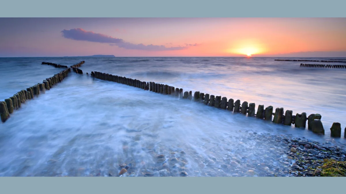
- The "Beach Width" Metric: Surveyors measure the distance from the defense structure to the waterline. This is a critical scientific proxy; if a seawall is present but the beach has vanished, the structure is failing to trap sand and is instead contributing to "scouring"—a process where waves bounce off the wall and pull sand away from the shore.
This "forced logic" ensures that even workers with minimal scientific training can produce data that meets the rigorous standards of the Ministry of Earth Sciences.

Supporting Data: A Coastline in Crisis
The findings from the Kerala pilot study reveal the staggering scale of the maintenance challenge facing coastal authorities. The survey mapped over 330 kilometers of seawalls and 459 individual groynes (rigid structures built perpendicular to the shore to interrupt water flow and limit sediment movement).
The data paints a grim picture:
- Seawall Integrity: A staggering 25% of the surveyed seawalls were found to be "completely disintegrated." These sections offer virtually no protection against storm surges.
- Partial Failure: Nearly 50% of the structures were classified as "partially damaged." While still standing, these defenses have lost their structural coherence and are likely to fail during the next major cyclonic event.
- Groyne Performance: Of the 459 groynes surveyed, many were found to be submerged or disconnected from the shore, rendered useless by the rising tide and shifting sands.
By amassing 20 gigabytes of photos and videos, the researchers have created a "digital twin" of the Kerala coast, allowing engineers to virtually walk the shoreline and inspect specific cracks or collapses from an office in Thiruvananthapuram or New Delhi.
The Economic Case: Drones vs. The Digital Framework
One of the most significant aspects of this research is its critique of "high-tech-only" solutions. While drones (UAVs) and LiDAR (Light Detection and Ranging) offer millimeter-level precision, they face insurmountable hurdles in tropical environments like India.
1. The Cloud Cover Problem:
During the monsoon—the very time when monitoring is most critical—Kerala is blanketed in thick cloud cover. This renders many optical satellites useless and makes drone flights hazardous and legally restricted.
2. The Cost Barrier:
Deploying a fleet of drones to monitor 600 kilometers of coast requires licensed pilots, expensive hardware, and massive data processing power. In contrast, the NCCR-Karlstad framework utilizes the "boots on the ground" already present in local coastal departments.

3. Reliability over Precision:
The researchers acknowledge that their system has a spatial accuracy limit of approximately 5 meters due to the constraints of consumer GPS. However, they argue that for the purposes of disaster management and maintenance planning, knowing which 5-meter section of a wall is crumbling is far more valuable than having a millimeter-perfect scan of a wall that the government cannot afford to monitor regularly.
Official Responses and Expert Perspectives
While the Ministry of Earth Sciences has long prioritized coastal protection, this new research provides a roadmap for more efficient resource allocation. Sources close to the project suggest that the data-driven nature of the app could revolutionize how "Blue Economy" funds are spent.
"The challenge has never been a lack of will to fix the walls; it has been a lack of accurate, up-to-date information on where the failure is most imminent," noted a researcher involved in the study. "By providing a cheap, repeatable way to map infrastructure, we allow resource-strapped local governments to pinpoint exactly where to send the repair crews."
Environmental scientists have also praised the move toward "standardized citizen science." By removing the ambiguity from field reports, the framework ensures that local observations can be translated into actionable engineering data.
Implications: A Blueprint for the Global South
The implications of this research extend far beyond the borders of Kerala. As climate change accelerates, the "Global South"—comprising nations often most vulnerable to sea-level rise and least equipped with high-tech monitoring budgets—needs tools that are both sophisticated and accessible.
Protecting Livelihoods
In Kerala alone, millions of people depend on the "coastal fringe" for fishing, tourism, and trade. When a seawall fails, it is not just a piece of infrastructure that is lost; it is the homes and livelihoods of entire communities. This digital framework provides a "pre-emptive strike" capability, allowing for repairs before a breach occurs.
Data-Driven Governance
This tool moves coastal management away from "reactive" governance—fixing things after they break—toward "proactive" asset management. It allows for a historical record of decay, helping scientists understand how different construction materials and designs hold up against the increasing ferocity of the Arabian Sea.
Future Enhancements
The research team is already looking at the next iteration of the app. Future versions may include AI-powered image recognition that can automatically detect the type of crack or structural failure from a photo, further reducing the need for expert interpretation in the field.
Conclusion: The Path Forward
The collaboration between India and Sweden has proven that in the fight against climate change, the most effective tools are not always the most expensive. By empowering field workers with the "Digital Sentinel" in their pockets, the National Centre for Coastal Research has provided a scalable, sustainable, and scientifically rigorous way to defend India’s shores.
As the 2026 monsoon season approaches, the deployment of this framework could mean the difference between a managed response and a coastal catastrophe. In the words of the research team, "We cannot stop the sea from rising, but we can finally see exactly where our defenses are falling."
