

September 15, 2026
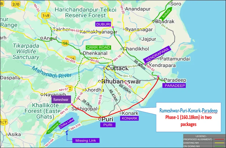
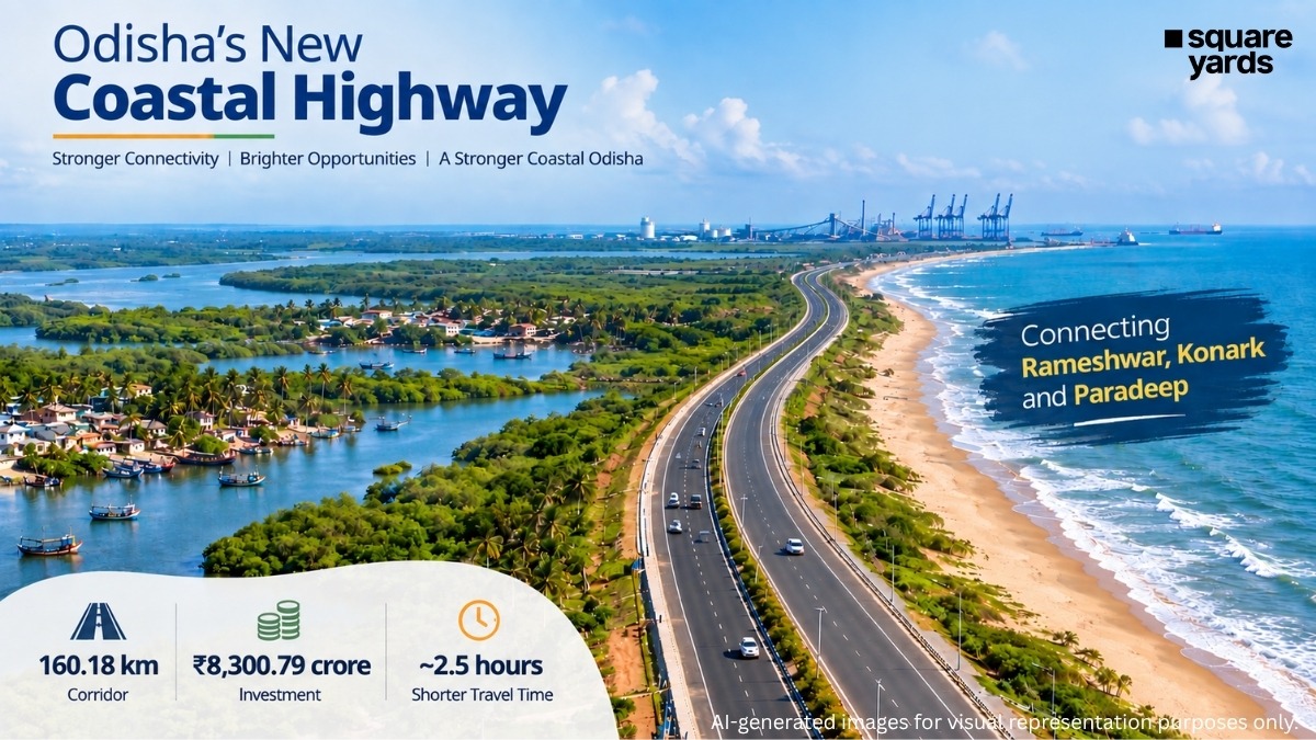
In a move set to redefine the socio-economic geography of India’s eastern seaboard, the Union Cabinet, chaired by the Prime Minister, has officially approved the development of the Odisha Coastal Highway Project. With a sanctioned investment of ₹8,300.79 crore, this ambitious infrastructure project aims to establish a high-speed, 160.18 km corridor connecting the strategic nodes of Rameshwar, Konark, and Paradeep.
The project represents a pivotal component of the government’s vision to enhance maritime logistics, bolster coastal tourism, and provide a robust alternative to the increasingly congested National Highway 16 (NH 16). By cutting travel time between the starting and ending points by approximately two and a half hours, the highway is poised to become the backbone of Odisha’s coastal economy.
1. Main Facts: The Blueprint of a Coastal Lifeline
The Odisha Coastal Highway Project is not merely a road-building exercise but a strategic multi-modal connectivity initiative. The project is designed to traverse four key districts: Khurda, Puri, Kendrapada, and Jagatsinghpur.
Key Project Specifications:
- Total Investment: ₹8,300.79 crore.
- Total Length: 160.18 kilometers.
- Route: Originates at Rameshwar (near NH 16), passes through the holy city of Puri and the heritage site of Konark, and terminates at the industrial powerhouse of Paradeep.
- Implementation Model: Hybrid Annuity Model (HAM).
- Travel Time Reduction: Estimated saving of 150 minutes (2.5 hours) for the full stretch.
- Design Speed: Engineered for speeds up to 100 km/h.
The project has been segmented into two distinct packages to ensure specialized focus on the varying geographic and traffic requirements of the coastline. Package I focuses on a 79.40 km four-lane access-controlled highway between Rameshwar and Konark. Package II involves an 80.78 km two-lane highway with paved shoulders extending from Konark to the port city of Paradeep.
2. Chronology: From Concept to Execution
The journey of the Odisha Coastal Highway has been one of rigorous planning and environmental calibration. For years, the need for a dedicated coastal route was discussed to bypass the saturated urban clusters of Bhubaneswar and Cuttack.
- Conceptualization & Feasibility (Pre-2024): Initial surveys identified the need to de-link long-distance coastal freight from local urban traffic on NH 16 and NH 316.
- Alignment Finalization (2024-2025): The government opted for a "Greenfield Alignment" for the majority of the corridor. This decision was crucial to avoid the bottlenecks of existing roadside developments and to minimize the displacement of established local communities.
- PM GatiShakti Integration (Early 2026): The project was mapped onto the PM GatiShakti National Master Plan to ensure it aligns with other infrastructure projects, such as the proposed Puri International Airport and the expansion of Paradeep Port.
- Cabinet Approval (September 2026): The Cabinet Committee on Economic Affairs (CCEA) provided the final financial and administrative nod, clearing the way for immediate bidding and construction.
- Future Timeline: Construction is slated to take 30 months (2.5 years). Following completion, the project includes a 15-year operation and maintenance (O&M) period, bringing the total concession cycle to 17.5 years.
3. Supporting Data: Technical Logistics and the HAM Framework
To understand the scale of the Odisha Coastal Highway, one must look at the technical and financial frameworks governing its construction.
The Hybrid Annuity Model (HAM)
The project will be executed under the Hybrid Annuity Model (HAM), a preferred route for modern Indian infrastructure. Under HAM, the National Highways Authority of India (NHAI) will fund 40% of the project cost through five equal installments during the construction phase. The remaining 60% is raised by the private developer.
This model is strategically chosen to mitigate risk for private players. Unlike the Build-Operate-Transfer (BOT) Toll model, where the developer bears the traffic risk, under HAM, the government collects the toll and pays the developer a fixed annuity over 15 years. This ensures that the project does not stall due to fluctuations in traffic volume, ensuring long-term sustainability.
Package Breakdown
-
Package I (Rameshwar to Konark):
- Length: 79.40 km.
- Type: 4-lane access-controlled highway.
- Purpose: This section caters to the high-density tourism traffic between the capital region and the "Golden Triangle" of Odisha (Bhubaneswar-Puri-Konark). Access control ensures that high-speed transit is not interrupted by local intersections.
-
Package II (Konark to Paradeep):
- Length: 80.78 km.
- Type: 2-lane with paved shoulders.
- Purpose: This stretch focuses on connecting the heritage zones with the industrial and maritime hubs. The paved shoulders are designed to accommodate heavy-duty breakdown vehicles and slower-moving local logistics without disrupting the main traffic flow.
4. Official Responses: A Vision for Integrated Development
The Union Government has emphasized that the Odisha Coastal Highway is a flagship project under the PM GatiShakti National Master Plan. Official statements from the Ministry of Road Transport and Highways (MoRTH) highlight that the project is not a standalone road but a "multimodal enabler."
Government Objectives:
- Relieving Congestion: Government spokespersons noted that NH 16 currently bears an unsustainable load of both interstate freight and local commuter traffic. By diverting coastal-bound traffic to the new highway, the "twin cities" of Bhubaneswar and Cuttack will see a significant reduction in heavy vehicle movement.
- Economic Node Connectivity: The highway is designed to link nine economic nodes and five logistics nodes. This includes direct access to the Multi-Modal Logistics Park (MMLP) in Jagatsinghpur and various Special Economic Zones (SEZs).
- Employment Generation: One of the most significant data points released by the government is the project’s impact on the labor market. The construction phase alone is expected to generate 53 lakh direct man-days and 67 lakh indirect man-days, providing a massive boost to local employment in the four coastal districts.
The official map released by the Press Information Bureau (PIB) illustrates a route that meticulously balances industrial utility with environmental sensitivity, ensuring that the highway serves as a barrier-free corridor for the movement of goods and people.
5. Implications: Tourism, Trade, and Transformation
The completion of the Odisha Coastal Highway will have far-reaching implications across multiple sectors of the state’s economy.
Transformation of the Tourism Sector
Odisha’s "Golden Triangle"—comprising Bhubaneswar, Puri, and Konark—is the crown jewel of its tourism industry. Currently, the journey between these points is often hampered by the narrow, congested lanes of NH 316. The new highway will provide a world-class driving experience for pilgrims visiting the Jagannath Temple and tourists visiting the UNESCO World Heritage site at Konark. Furthermore, the proximity to the proposed Puri International Airport means that international tourists can transition from air to road seamlessly, reaching coastal resorts in record time.
Boosting Maritime Trade and Port Efficiency
Paradeep Port is one of India’s largest major ports by cargo volume. The efficiency of a port is only as good as its "hinterland connectivity"—the ease with which goods move from the port to the rest of the country. By connecting Paradeep to Rameshwar via a high-speed corridor, the highway creates a faster exit route for imported raw materials and an entry route for export-oriented finished goods. The link to Astarang Port further solidifies this maritime network.
Real Estate and Industrial Growth
Historically, large-scale highway projects in India have led to a surge in real estate value along the corridor. The Rameshwar-Paradeep stretch is expected to see the emergence of new warehousing hubs, cold storage facilities for the fishing industry, and hospitality projects. The improved connectivity to fishing clusters will allow local fishermen to transport perishable goods to markets in Bhubaneswar or ports for export much faster, reducing wastage and increasing profit margins.
Environmental and Social Impact
By adopting a fresh, greenfield alignment for most of the route, the project avoids the social friction of large-scale demolition in established towns. While it opens up new areas for development, it also requires a commitment to environmental safeguards, given the proximity to the sensitive coastal ecosystem. The government has integrated modern drainage systems and green belts along the highway to mitigate the ecological footprint.
Conclusion: A New Era for Odisha’s Coastline
The Odisha Coastal Highway Project is a testament to the shift in India’s infrastructure philosophy—moving away from incremental expansions of old roads toward the creation of dedicated, high-speed economic corridors. With ₹8,300.79 crore in funding and a clear 30-month execution window, the project is set to transform Odisha from a state with "potential" into a realized industrial and tourism powerhouse.
As the bidding process commences, the focus now shifts to the ground-level execution. For the residents of Khurda, Puri, Kendrapada, and Jagatsinghpur, the highway promises more than just shorter travel times; it promises a gateway to new economic opportunities, better jobs, and a modernized landscape that respects both its heritage and its future.
