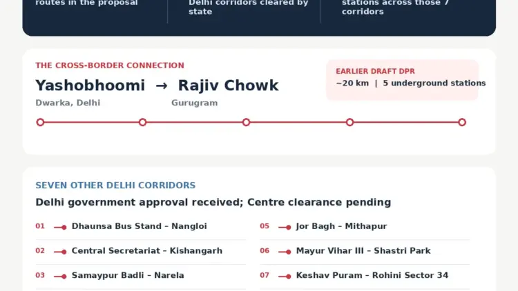
New Delhi, November 20, 2026 – The landscape of the National Capital Region (NCR) is poised for a transformative shift as the Delhi Metro Rail Corporation (DMRC) moves toward its most ambitious expansion phase yet. The proposed Delhi Metro Phase V(B) expansion, comprising eight strategic corridors, aims to bridge critical gaps in the city’s transit network while forging a vital new link between the sub-city of Dwarka and the corporate hub of Gurugram.
As urban congestion reaches a critical juncture, the Phase V(B) project represents a multi-billion rupee commitment to sustainable mobility. With seven routes already securing approval from the Delhi Government and awaiting the final nod from the Union Ministry of Housing and Urban Affairs, the project is set to redefine the socio-economic geography of northern India’s most populous metropolitan area.
I. Main Facts: The Blueprint of Phase V(B)
The Phase V(B) expansion is designed to address the "last-mile" connectivity issues and the growing demand for rapid transit in Delhi’s outer peripheries. According to the latest project reports, the expansion will encompass a total of 65 stations across seven of the eight proposed corridors.
The Dwarka-Gurugram Connection
The crown jewel of the Phase V(B) proposal is the high-capacity link connecting Yashobhoomi (Dwarka Sector 25) to Rajiv Chowk in Gurugram. This 20-kilometer corridor is envisioned primarily as an underground route, designed to bypass the surface-level traffic bottlenecks of the Delhi-Gurugram border. Initial Detailed Project Reports (DPR) suggest a lean but efficient layout of five underground stations, strategically placed to serve both residential clusters and commercial zones.
Expansion into the Peripheries
Beyond the Gurugram link, the expansion focuses heavily on the "neglected" sectors of Delhi. This includes:
- North Delhi Extension: Stretching the Yellow Line from Samaypur Badli to the Narela DDA Sports Complex.
- West-Northwest Connectivity: A new 16.3 km corridor from Keshav Puram to Rohini Sector 34.
- South Delhi Depth: A 15.9 km link from Central Secretariat to Kishangarh, featuring a sophisticated underground network.
II. Chronology: From Conception to Pending Approvals
The journey toward Phase V(B) has been marked by rigorous planning and inter-governmental negotiations.
- Pre-2024: Initial feasibility studies conducted by DMRC identified significant "blind spots" in the Phase IV network, particularly in Narela and the burgeoning sectors of Gurugram.
- Early 2026: The Delhi Government reviewed the socio-economic impact of the proposed routes. Following several rounds of revisions regarding station placement and elevated vs. underground ratios, the state cabinet approved seven of the eight proposed corridors.
- July 2026: A landmark Detailed Project Report (DPR) was submitted for the Yashobhoomi Dwarka–Rajiv Chowk link. This report highlighted the necessity of an underground alignment to navigate the complex land ownership and existing infrastructure between the two cities.
- November 2026: As of the current date, the seven approved routes are under active review by the Central Government. Financial modeling and debt-equity ratios are being finalized, while the Yashobhoomi-Gurugram link remains in the final stages of DPR validation.
III. Supporting Data: Corridor Specifications and Technical Details
The Phase V(B) expansion is a mix of elevated and underground engineering marvels. Below is a detailed breakdown of the proposed corridors based on the latest DMRC filings:
Detailed Corridor Overview
| Proposed Corridor | Distance | Station Count | Technical Profile |
|---|---|---|---|
| Yashobhoomi (Dwarka) – Rajiv Chowk (GGM) | 20 km | 5 | Fully Underground; Strategic link to IFFCO Chowk |
| Keshav Puram – Rohini Sector 34 | 16.3 km | 12 | Elevated; Serving high-density residential zones |
| Jor Bagh – Mithapur | ~17 km | 12 | Mixed; 7 underground stations to preserve heritage areas |
| Central Secretariat – Kishangarh | 15.9 km | 10 | Primarily Underground (9 stations) |
| Mayur Vihar Ph-III – Shastri Park | 13.2 km | 8 | 9 km underground stretch to navigate East Delhi |
| Samaypur Badli – Narela DDA Complex | 12.9 km | 8 | Elevated extension of the Yellow Line |
| Dhansa Bus Stand – Nangloi | 11.9 km | 9 | Elevated; Vital interchange at Nangloi |
| Kirti Nagar – Palam | 9.9 km | 6 | 5 underground stations; Extension of the Green Line |
Strategic Interchanges
The proposed Phase V(B) is not merely about adding length; it is about creating a "web" of connectivity. Key planned interchanges include:
- Nangloi: Connecting the new Dhansa line with the existing Green Line.
- Shastri Park: Linking East Delhi’s Phase III sectors to the Red Line.
- IFFCO Chowk (Proposed): Serving as a massive multi-modal hub between the Yashobhoomi link and Gurugram’s existing Yellow Line.
IV. Official Responses and Institutional Framework
The DMRC has maintained a cautious but optimistic stance. Officials close to the development state that Phase V(B) is designed to handle the projected ridership of 2030 and beyond.
The Delhi Government’s Position:
State officials have emphasized that these corridors are essential for "equitable urban growth." By extending the metro to Narela and Rohini Sector 34, the government aims to de-congest Central Delhi and encourage the development of peripheral business districts.
Central Government Review:
The Ministry of Housing and Urban Affairs is currently evaluating the "Financial Internal Rate of Return" (FIRR) for these routes. Given the high cost of underground construction—particularly for the Kishangarh and Yashobhoomi routes—the Center is scrutinizing the ridership projections to ensure long-term viability.
Gurugram’s Parallel Infrastructure:
It is important to note that the Yashobhoomi–Rajiv Chowk link is distinct from the recently sanctioned 28.5-km Millennium City Center–Cyber City corridor. While the latter is a Haryana-led initiative, the Phase V(B) link is a cross-border project that requires a unique collaborative framework between the DMRC, the Delhi Government, and the Haryana Government.
V. Implications: Real Estate, Economy, and Urban Mobility
The announcement of Phase V(B) has already begun to influence market sentiment across the NCR, though experts warn that actual value appreciation will follow the "approval-to-execution" timeline.
Real Estate Market Snapshot
Data provided by Square Yards Research offers a glimpse into the current residential landscape near the proposed corridors. These figures represent average asking prices as of late 2026:

- Gurugram Sector 22: ₹21,250 per sq. ft. (Reflecting its status as a premium corporate-adjacent hub).
- Mayur Vihar: ₹17,050 per sq. ft. (High demand due to established infrastructure).
- Dwarka Sector 25: ₹11,250 per sq. ft. (Expected to see high volatility once construction begins).
- Palam: ₹7,600 per sq. ft. (Mid-market segment poised for growth).
- Narela: ₹5,000 per sq. ft. (The most affordable segment, likely to attract long-term investors).
The "Metro Premium" and Housing Demand
While these prices are currently based on market listings, the "Metro Effect" typically manifests in three stages: the Announcement Spike, the Construction Plateau, and the Operational Surge. For areas like Narela and Rohini Sector 34, the metro isn’t just a convenience; it is a catalyst for formalizing the local economy.
However, the real estate impact is nuanced. Analysts suggest that the proximity to underground stations often commands a higher premium than elevated stations due to reduced noise pollution and better integration with commercial "hubs."
Socio-Economic Impact
- Workforce Mobility: The link between Dwarka and Gurugram will allow thousands of professionals to commute between these two hubs in under 30 minutes, significantly reducing the load on the Dwarka Expressway and NH-48.
- Industrial Growth: The extension to Narela is expected to provide a massive boost to the industrial estates in North Delhi, allowing workers from across the city to access jobs that were previously considered too distant.
- Environmental Benefits: By shifting an estimated 250,000 daily commuters from private vehicles to the metro, Phase V(B) could contribute to a significant reduction in the NCR’s annual carbon footprint.
VI. Looking Ahead: Challenges and Expectations
Despite the momentum, Phase V(B) faces several hurdles. Land acquisition in densely populated areas like Mayur Vihar Phase III and Najafgarh remains a sensitive issue. Furthermore, the technical complexity of the 9-km underground stretch in East Delhi will require advanced Tunnel Boring Machines (TBMs) and meticulous planning to avoid disrupting existing utilities.
No official commencement date has been set, but industry insiders suggest that if Central approval is granted by mid-2027, the first sections of Phase V(B) could be operational by 2031-2032.
As the National Capital Region continues to expand, Phase V(B) represents more than just a series of tracks and stations; it is the skeletal structure upon which the next decade of Delhi’s growth will be built. For residents of Bijwasan, Kapashera, and Narela, the "coming of the Metro" remains the most anticipated development in their urban history.