
JORHAT, ASSAM — In a region where the earth is seldom still, scientists have achieved a breakthrough that could redefine how the Indian subcontinent prepares for its next major seismic event. Researchers at the CSIR-North East Institute of Science and Technology (CSIR-NEIST) have unveiled a sophisticated new seismic model that tracks the precise movement and energy decay of earthquake waves as they traverse the highly active crust of Northeast India.
The study, which offers a high-resolution "biopsy" of the earth’s crust, provides the most detailed map to date of seismic attenuation in the region. By understanding how the ground absorbs and scatters energy, engineers and urban planners now have the mathematical tools necessary to design infrastructure that can withstand the unique geological pressures of one of the world’s most earthquake-prone zones.
The Main Facts: Deciphering the Crustal Quality Factor
Northeast India sits at a precarious tectonic junction, squeezed between the colliding Indian and Eurasian plates to the north and the Indo-Burmese subduction zone to the east. This "tectonic knot" has made the region a laboratory for seismologists, but the complexity of its underground structures has historically made ground-motion prediction a challenge.
The CSIR-NEIST study focuses on "seismic attenuation"—the process by which seismic waves lose their intensity as they travel through the Earth. This loss of energy is measured by the "crustal quality factor" (Q). A high Q-factor indicates a solid, cold, and stable crust where waves travel long distances with little energy loss (similar to a bell ringing clearly). Conversely, a low Q-factor indicates a "shattered," hot, or fluid-filled crust that rapidly scatters and absorbs energy.

The findings are stark: Northeast India possesses a remarkably low average crustal quality factor, signaling a crust that is intensely fractured and geologically "soft." The study revealed that the region’s crustal attenuation is highly frequency-dependent, a characteristic shared by other global seismic hotspots such as Mexico and Colombia. This "shattered" nature of the crust acts as a geographical fingerprint, revealing the immense stress of ongoing tectonic collisions and the presence of underlying low-velocity zones and trapped fluids.
A Chronology of Seismicity: A Century of Turbulence
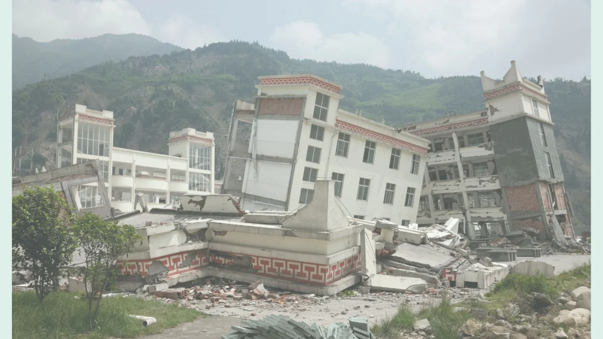
To understand the urgency of this model, one must look at the historical context of the region. Northeast India is classified under Seismic Zone V—the highest risk category.
- 1897 – The Great Shillong Earthquake: A magnitude 8.1 event that remains one of the most powerful intraplate earthquakes ever recorded. It leveled the city of Shillong and altered the course of rivers.
- 1950 – The Assam-Tibet Earthquake: A magnitude 8.6 behemoth that caused widespread destruction, landslides, and flooding, fundamentally changing the topography of the Brahmaputra Valley.
- The Last Century: Over the past 100 years, the region has experienced approximately twenty major earthquakes (magnitude > 7.0) and thousands of smaller tremors.
- 2007–2012 – The Data Window: For the current study, researchers analyzed a specific window of seismic activity. They utilized a regional network of sensitive broadband seismic stations to record data from 30 moderate earthquakes that occurred during this five-year period.
- 2024–2026 – The Development of the Model: After years of analyzing 120 unique underground pathways, the CSIR-NEIST team finalized the current model, providing a blueprint for future disaster mitigation.
Supporting Data: The Mechanics of the Lg Wave
The cornerstone of the research is the analysis of the Lg wave. Unlike primary (P) or secondary (S) waves that travel through the deep body of the Earth, Lg waves are high-frequency seismic waves trapped within the Earth’s crust. They are formed by the superposition of multiple waves bouncing between the surface and the base of the crust.
Why Lg Waves Matter
Seismologists focus on Lg waves because they are typically the most energetic and destructive waves at regional distances. They carry the bulk of the energy that causes buildings to collapse and bridges to fail.

Study Parameters
- Sample Size: 30 moderate earthquakes.
- Magnitude Range: 3.1 to 4.6. The researchers specifically chose "moderate" tremors to ensure the signals were clear enough to analyze without the "clipping" or noise saturation often found in massive quakes.
- Distance Capping: The team tracked wave decay over distances of up to 600 kilometers. Beyond 600km, Lg waves tend to blend into other seismic phases, making the data unreliable for specific crustal modeling.
- The Three-Zone Analysis: The study divided the region into three distinct geological domains:
- The Arunachal Himalayas: High scattering due to the collision of the Indian and Eurasian plates.
- The Indo-Burman Ranges: Characterized by complex subduction dynamics.
- The Shillong Plateau: Found to have the highest level of attenuation. The plateau’s intensely deformed subterranean structure suggests it is a primary "sink" for seismic energy, likely due to its highly fractured state following the 1897 event.
Official Responses and Scientific Context
The research, led by scientists at the CSIR-North East Institute of Science and Technology in Jorhat, has been hailed as a vital step toward "indigenous disaster resilience."
In statements regarding the study’s release, the research team emphasized that while we cannot prevent earthquakes, we can prevent the catastrophe that follows. "The fractured nature of the local crust strongly scatters seismic energy," the lead researchers noted. "By quantifying this scattering, we move from guesswork to precision engineering."
The scientific community has noted that this model fills a critical gap. Most previous seismic models for India were generalized or based on data from the more stable Deccan Plateau. This region-specific model accounts for the unique "mushy" and fractured geological reality of the Northeast, where the crust behaves differently than in the rest of the country.
Implications: Building for a Shaky Future
The practical applications of this seismic model extend far beyond the laboratory. It serves as a foundational document for the next generation of civil engineering in India.

1. Revolutionizing Building Codes
Current building codes often rely on broad generalizations of ground shaking. With the new Lg wave model, engineers can use specific mathematical equations—known as Ground Motion Prediction Equations (GMPEs)—to calculate exactly how much force a building at a specific location in, say, Guwahati or Itanagar, will experience during a magnitude 7.0 quake.
2. Infrastructure Resilience
Large-scale projects, including the massive hydroelectric dams planned in Arunachal Pradesh and the expanding network of bridges over the Brahmaputra, can now be stress-tested against the specific attenuation factors of the local crust. If the crust scatters energy quickly (low Q), the "shock" to a structure might be shorter but more intense, requiring different damping technologies.
3. Urban Planning and Disaster Risk Reduction (DRR)
City planners can use the model to create "micro-zonation" maps. These maps identify areas where the ground is likely to amplify shaking versus areas where the crust will absorb it. This allows for smarter land-use policies, ensuring that critical facilities like hospitals and schools are built on the most stable ground possible.
4. Protecting Lives
Ultimately, the study’s goal is the preservation of life. By providing a high-resolution, region-specific picture of the shallow continental crust, CSIR-NEIST has given the people of Northeast India a fighting chance. As the Indian plate continues its relentless march northward at about 5 centimeters per year, the accumulation of stress is inevitable. This model ensures that when that stress is finally released, the structures above ground will be ready.
Conclusion
The work of the CSIR-NEIST scientists represents a marriage of high-level physics and practical humanitarianism. In the complex, shattered crust beneath the Shillong Plateau and the Arunachal Himalayas, they have found a way to read the Earth’s internal language. This new seismic model does more than just track waves; it provides a roadmap for a more resilient Northeast India, ensuring that the "Land of the Seven Sisters" can stand firm even when the ground beneath it begins to move.
