

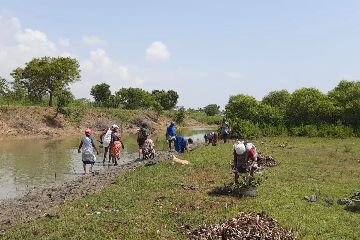
CUDDALORE, TAMIL NADU – Long before the sun reaches its zenith over the Uppanar River, the silence of the Kudikadu fishing hamlet is broken by the rhythmic splashing of boots in the mud. A local forester and a small team of villagers navigate the intricate labyrinth of a mangrove nursery, racing against the turning tide. Their tools are modest: no high-frequency satellite receivers or autonomous drones are in sight. Instead, they carry weathered notebooks and graphite pencils.
They are recording the "ground truth"—counting saplings, marking the survival rates of the latest spring tide, and identifying which species are succumbing to the creeping salinity of the brackish water. This scene is being replicated across the Tamil Nadu coastline, where hundreds of villagers, enrolled in Village Mangrove Councils (VMCs), are walking their local stretches of coast.
While the world watches global reforestation efforts through the lens of high-resolution satellite imagery, these villagers are providing something technology cannot: a granular, season-by-season account of ecological health. As Tamil Nadu embarks on one of India’s most ambitious coastal restoration projects, a critical debate has emerged: Can we trust a restoration story told entirely from space?
The Main Facts: A Statistical Surge and the "Green" Debate
Tamil Nadu’s mangrove narrative is currently defined by a staggering statistical leap. According to a recent assessment by Anna University’s Department of Remote Sensing, the state’s mangrove cover has effectively doubled in a remarkably short window. The report indicates that the total area grew from approximately 4,500 hectares (ha) in 2021 to 9,039 ha in 2024.
This increase is attributed to a combination of aggressive plantation drives and enhanced protection measures. According to the data, the current total is comprised of:
![Community-based mangrove monitoring should compliment satellite data [Commentary]](https://imgs.mongabay.com/wp-content/uploads/sites/30/2026/09/22101938/02_Kudikadu_UM-1200x800.jpg)
- Existing Mangrove Forests: 5,414 ha (59.9%)
- New Plantations: 3,625 ha (40.1%)
However, this rapid expansion has sparked a rigorous debate within the scientific and environmental communities. While the state celebrates the doubling of "green cover," researchers are questioning the quality of this growth. The central point of contention is whether these figures represent genuine, self-sustaining ecological recovery or simply "more pixels reading as canopy."
The limitation of area-based estimates is that they provide a binary view: forest or non-forest. They fail to distinguish between a thriving, multi-species ecosystem and a fragile monoculture of even-aged saplings that might perish during a single harsh monsoon.
Chronology: The Evolution of Tamil Nadu’s Mangrove Mission
The journey to this 9,039-hectare milestone has been decades in the making, but the pace has accelerated significantly in the last three years.
- Pre-2021: Mangrove restoration in Tamil Nadu was largely localized, often led by NGOs like the M.S. Swaminathan Research Foundation (MSSRF) and the Forest Department in specific pockets like Pichavaram and Muthupet.
- 2021-2022: The State Government of Tamil Nadu prioritized coastal resilience, integrating mangrove restoration into its climate change adaptation strategies. This period saw the formalization of "Bio-shields" to protect against cyclones and storm surges.
- 2023: The launch of the Union Government’s MISHTI (Mangrove Initiative for Shoreline Habitats & Tangible Incomes) scheme provided a federal impetus, aligning state efforts with national "blue carbon" goals.
- 2024: The Anna University report is released, claiming a 100% increase in cover over three years. Simultaneously, World Bank-supported coastal resilience funding is funneled into the state, elevating the stakes for accurate monitoring.
Supporting Data: The Blind Spots of Remote Sensing
Remote sensing is an indispensable tool for environmental monitoring. It can map broad trends across a 1,000-kilometer coastline in a single pass, detecting large-scale clearing or massive dieback that field teams might miss. However, as the scale of restoration grows, the "bluntness" of satellite data becomes a liability.
Scientific literature increasingly highlights the "resolution gap." A satellite image can confirm that a canopy exists, but it cannot identify:
![Community-based mangrove monitoring should compliment satellite data [Commentary]](https://imgs.mongabay.com/wp-content/uploads/sites/30/2026/09/22103535/04_Kudikadu_UM-scaled-e1790053562821-768x512.jpg)
- Species Diversity: Is the site a healthy mix of Avicennia marina, Rhizophora, and Ceriops, or a vulnerable monoculture?
- External Stressors: Is an upstream aquaculture pond quietly increasing the salinity of a restoration plot?
- Localized Threats: Are goats or cattle grazing on young seedlings in specific patches?
- Early-Stage Disease: A pest outbreak might kill young Avicennia months before the loss of leaf reflectance is detectable by a satellite.
The "Village Mangrove Councils" (VMCs) act as the corrective lens for this data. These bodies, registered as societies and led by village presidents alongside forest range officers, provide the daily monitoring required to catch these nuances. Fisherfolk and forest watchers notice a dying sapling or a silted creek mouth long before the next satellite pass, providing a form of ecological data that is currently undervalued in official reporting.
Official Responses and Policy Frameworks
The surge in restoration activity is backed by significant financial and political capital. Public spending on coastal projects in Tamil Nadu has crossed hundreds of crores, with the state effectively leveraging international and federal support.
The World Bank and Coastal Resilience
Tamil Nadu has successfully folded World Bank-supported funding into its coastal plans. These funds are specifically earmarked for "resilience," meaning the mangroves are not just expected to exist—they are expected to perform the biological function of protecting human settlements. This puts pressure on the state to prove that the 9,039 hectares are functional, not just visible.
The MISHTI Scheme
The Centre’s MISHTI scheme focuses on the nexus between shoreline habitat and tangible income. By linking mangrove health to climate finance and "blue carbon" credits, the scheme demands a level of verification that can withstand international auditing. If carbon credits are to be sold based on these forests, the monitoring must be beyond reproach.
The Forest Department’s Role
The Tamil Nadu Forest Department has transitioned from a traditional "protection" role to one of "community partnership." By setting up VMCs, the department acknowledges that it cannot police or monitor the entire coast alone. However, the integration of VMC data into the official reporting remains an informal process that critics say needs to be standardized.
![Community-based mangrove monitoring should compliment satellite data [Commentary]](https://imgs.mongabay.com/wp-content/uploads/sites/30/2026/09/22103951/01_Kudikadu_UM-e1790053812720-768x512.jpg)
Implications: Building a "Shore-Verified" Future
The stakes of getting the monitoring right extend far beyond the borders of Cuddalore or even Tamil Nadu. As climate finance flows into nature-based solutions, the "Tamil Nadu model" could serve as either a cautionary tale of inflated numbers or a global blueprint for community-led restoration.
1. Transparency and Auditor Scrutiny
As the money grows, so does the need for transparency. For donors and the public to trust claims of restoration success, area figures must be backed by dated, geotagged, and verifiable ground observations. Without this, "greenwashing" remains a persistent risk.
2. Methodological Shifts
Experts suggest that building a robust system does not require massive new budgets, but rather a change in protocol. A simple, standardized mobile application could allow VMC members to record:
- Sapling survival rates.
- Presence of invasive species.
- Water salinity levels.
- Photographic evidence of canopy health.
This data should flow into the same architecture used for satellite classification. When a discrepancy arises—for instance, when a satellite sees "green" but a villager reports "pest infestation"—it should trigger an immediate field intervention.
3. From Laborers to Partners
The most profound implication is social. For decades, coastal communities have been treated as "plantation labor"—paid to dig holes and move saplings. Shifting the focus to community monitoring treats these individuals as scientific partners. When a Village Mangrove Council has ownership over the data, they have a genuine stake in the survival of the forest.
![Community-based mangrove monitoring should compliment satellite data [Commentary]](https://imgs.mongabay.com/wp-content/uploads/sites/30/2026/09/22104104/05_Kudikadu_AA-768x512.jpeg)
4. A Global Blueprint
Coastal states across India—and mangrove-rich regions in Southeast Asia and Africa—face the same dilemma: restoration is scaling faster than the ability to verify it from a desk. Integrating local observations formally into monitoring systems would strengthen the credibility of blue carbon commitments worldwide.
Conclusion: The Test of Survival
Ultimately, the success of Tamil Nadu’s mangrove mission will not be judged by how much green appears on a map in Chennai or New Delhi. It will be judged by whether those mangroves are alive, whether they are healthy enough to withstand the next cyclone, and whether they continue to provide a livelihood for the fisherfolk standing in the mud beneath them.
As the state scales its ambitions, it has a rare opportunity to move beyond the pixel. By pairing the bird’s-eye view of the satellite with the ground-level wisdom of the community, Tamil Nadu can ensure that its story of doubling mangrove cover is not just a statistical triumph, but an ecological reality. Getting that answer right requires both the high-tech lens in orbit and the pencil-wielding villager on the shore.
Data Summary: Tamil Nadu Mangrove Assessment (2021-2024)
| Category | Area (Hectares) | Percentage of Total |
|---|---|---|
| Existing Mangrove Forest | 5,414 | 59.9% |
| New Plantations | 3,625 | 40.1% |
| Total Mangrove Cover | 9,039 | 100% |
Source: Anna University Department of Remote Sensing / Tamil Nadu Forest Department.
