

In the village of Konta, nestled in the Sukma district of southern Chhattisgarh, the rhythm of life has long been dictated by the Sabari river and the surrounding dense forests. For Manglu Dorla, a farmer whose family has tilled this soil for generations, the land is more than a resource; it is an ancestral legacy. The forest provides fuel and fodder, while the river sustains his crops. However, this ancient connection to the land is now under threat.
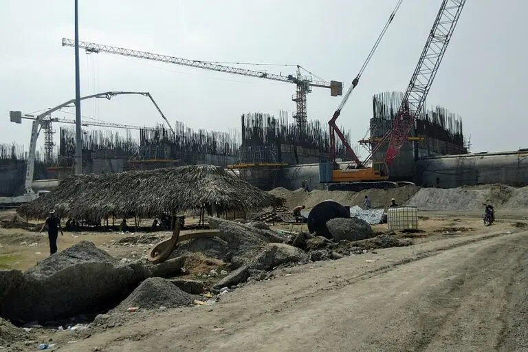
A massive engineering endeavor—the Polavaram Irrigation Project (PIP)—is under construction more than a hundred kilometers downstream on the Godavari river in Andhra Pradesh. While the project is hailed as a lifeline for Andhra Pradesh’s coastal plains, it has cast a long, dark shadow over the tribal heartlands of Chhattisgarh and Odisha. For Manglu and thousands of others in the Konta region, the future is a murky landscape of potential submergence and forced migration.
“None of us wants to leave our home,” Dorla says, echoing a sentiment shared by thousands of indigenous residents who find themselves caught in a decades-long interstate dispute. As the project nears its revised completion date, the lack of clear maps and official data has left these communities in a state of agonizing limbo.
I. Main Facts: A National Project with Transboundary Consequences
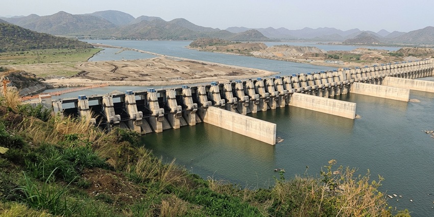
The Polavaram Irrigation Project is an ambitious multi-purpose reservoir located on the Godavari river near Ramanayyapeta in Andhra Pradesh. Positioned approximately 42 kilometers upstream of the Sir Arthur Cotton Barrage, the dam is designed to stand at an elevation of 45.72 meters (150 feet).
Project Objectives
According to official government filings and the 2025 Comptroller and Auditor General (CAG) report, the PIP aims to:
- Irrigation: Create a potential for 2.91 lakh hectares of farmland.
- Hydropower: Generate 960 MW of electricity.
- Water Supply: Provide drinking water to 28.5 lakh people across 540 villages.
- Inter-basin Transfer: Divert 80 TMC (Thousand Million Cubic feet) of Godavari water to the Krishna river basin to alleviate water scarcity in other regions.
The Geography of Submergence
The primary concern for Chhattisgarh revolves around the Sabari river, a major tributary of the Godavari. The Sabari originates in the Eastern Ghats of Odisha, forms a natural boundary between Odisha and Chhattisgarh, and flows past Konta before joining the Godavari. When the Polavaram dam is closed, the resulting reservoir will create a "backwater effect," pushing water back up the Sabari.
While Andhra Pradesh stands to gain immense agricultural and industrial benefits, the upstream regions face the permanent loss of land, homes, and cultural heritage. The central point of contention remains the "Full Reservoir Level" (FRL) and how far the backwaters will reach during peak monsoon seasons.
II. Chronology: Decades of Negotiation and Legal Deadlock
The history of Polavaram is a complex tapestry of post-independence engineering dreams and modern-day legal battles.
- 1978–1980: Initial interstate agreements are signed between Andhra Pradesh, Odisha, and Madhya Pradesh (before the creation of Chhattisgarh). These agreements laid the groundwork for the dam’s height and the necessity of protective measures for upstream states.
- 2004: Construction officially begins under the Andhra Pradesh government.
- 2005–2006: Environmental and forest clearances are granted, though they are immediately contested by neighboring states.
- 2007–2011: Odisha and Chhattisgarh move the Supreme Court of India, challenging the project’s clearances and raising alarms about the lack of public hearings in their respective territories.
- February 2011: The Ministry of Environment and Forests (MoEF) issues a "stop-work order" due to violations of environmental clearance conditions.
- 2014: The Union Government declares Polavaram a National Project under the Andhra Pradesh Reorganisation Act. This shift means the central government now funds the project, while the state of Andhra Pradesh executes the construction.
- 2011–2024: The stop-work order is kept in "abeyance" (temporary suspension) through a series of extensions, allowing construction to continue despite unresolved legal and environmental questions.
- August 2024: The Union Cabinet approves approximately ₹30,436.95 crores to complete the first phase of the reservoir.
- August 2024: Andhra Pradesh Chief Minister N. Chandrababu Naidu sets a definitive deadline of 2027 for the project’s completion.
III. Supporting Data: The Discrepancy in Submergence Figures
One of the most distressing aspects for the residents of Sukma is the lack of a definitive "submergence map." Over the years, the estimated number of affected villages has fluctuated wildly depending on the source.
Conflicting Estimates:
- Union Government (2013): Stated in Parliament that eight villages in Chhattisgarh would be submerged.
- Chhattisgarh State Government (2020): Identified nine villages at risk: Banjamgunda, Metaguda, Pedakisoli, Asirguda, Injaram, Fandiguda, Dhondra, Konta, and Venkatpuram. This involves an estimated population of 18,510 people.
- CAG Report (2025): Flags that without protective embankments, 12 villages across Chhattisgarh and Odisha could be submerged, affecting 3,337 "Project Affected Families" (PAFs).
- Bastariya Raj Morcha (BRM) (2026): Local political and social organizations claim the number is actually 18 villages or more, given the recent patterns of flooding in the Sabari basin.
The Embankment Failure
To mitigate submergence, the original project report (dating back to 1980) proposed 29.12 kilometers of protective embankments in Chhattisgarh and 30 kilometers in Odisha. However, the 2025 CAG performance audit revealed a startling reality: construction on these embankments has not even begun.

The delay is attributed to a "catch-22" situation. Construction cannot start without public hearings and environmental clearances in the affected states. However, the pollution control boards of Odisha and Chhattisgarh refuse to hold these hearings, arguing the matter is sub judice (under judicial consideration) and that the full technical facts of the project have never been transparently shared by the Union or Andhra Pradesh governments.
IV. Official Responses: A Game of Political Pass-the-Parcel
The response from various levels of government highlights a significant gap between administrative planning and grassroots reality.
The Expert View
Himanshu Thakkar, coordinator at the South Asia Network on Dams, Rivers & People (SANDRP), describes the situation as a "complete violation of the law." He points out that the environmental clearance remains technically suspended and that the "backwater impact" has never been accurately assessed using modern hydrological modeling. "There have been violations of the Forest Rights Act (FRA) and many other regulations," Thakkar notes, criticizing both state and central authorities for allowing the project to proceed without addressing these fundamental flaws.
The State of Chhattisgarh
The political landscape in Chhattisgarh is fraught with accusations. Deepak Baij, the state Congress president, has accused the current administration of failing to protect its citizens despite the same political alliance holding power in the Center, Andhra Pradesh, and Chhattisgarh.
On September 28, 2026, Chhattisgarh Chief Minister Vishnu Deo Sai visited the flood-hit areas of Sukma. He admitted that the number of villages affected by the Polavaram project might exceed 18 and stated that the government is "monitoring the situation." However, for many locals, "monitoring" is a poor substitute for a concrete rehabilitation plan.

The MP’s Promise
Mahesh Kashyap, the Member of Parliament from Bastar, has promised to bring the issue to the floor of Parliament. He stated that survey reports from both Andhra Pradesh and Chhattisgarh will be compared to find the truth. Yet, as of late 2026, these survey reports remain largely inaccessible to the public.
V. Implications: Cultural Erosion and the Human Cost
Beyond the technical data and political maneuvering lies the existential threat to the Koya and Dorla indigenous tribal communities. For these groups, displacement is not merely a change of address; it is a severance of their cultural and spiritual identity.
Cultural and Economic Displacement
Manish Kunjam, a former MLA and leader of the Bastariya Raj Morcha (BRM), emphasizes that the impact on tribal life will be "severe." The BRM has demanded:
- A comprehensive, transparent public survey.
- Full disclosure of affected persons and properties.
- Compensation and resettlement before any displacement occurs.
- Education in local tribal languages and alternative employment at resettlement sites.
The "Silent" Submergence
The Andhra Pradesh government has proposed a "phased approach," intending to keep water levels at 41.15 meters initially to avoid interstate submergence. However, critics argue this is a tactical move to complete the dam structure first, making the eventual rise to 45.72 meters an inevitability that neighboring states will be powerless to stop.
For families like Manglu Dorla’s, this phased approach offers no comfort. They live in a state of perpetual anxiety, unable to invest in their land or plan for their children’s futures because they do not know if their homes will exist five years from now.

Conclusion: A Crisis of Transparency
The Polavaram Irrigation Project stands as a monument to India’s engineering ambition, but it also serves as a cautionary tale of how "National Projects" can marginalize vulnerable populations across state lines. The "missing maps" of Polavaram represent more than a technical failure; they represent a breakdown in the social contract between the state and its most marginalized citizens.
Until a transparent, independent, and scientific assessment of the backwater impact is conducted—and until the residents of Konta are given a seat at the table—the Sabari river will continue to flow not with the promise of prosperity, but with the chilling uncertainty of a coming flood.
