
KHARAGPUR – In the fertile heart of the Central Ganga Basin, a region often hailed as the "Food Bowl of India," the ground beneath the feet of millions holds a restless history. While the modern landscape is defined by sprawling wheat fields and dense settlements, a multidisciplinary team of Indian scientists has uncovered a more turbulent past. By analyzing the sedimentary remains of a dried-up oxbow lake near Sahaswan, Uttar Pradesh, researchers have decoded a 4,500-year-old chronicle of shifting rivers, seismic shifts, and the rise and fall of empires.
The study, a collaborative effort between the Indian Institute of Technology (IIT) Kharagpur, the Inter University Accelerator Centre, IIT Roorkee, and the Indian Institute of Science Education and Research (IISER) Kolkata, provides a stark reminder that the geography of India is not a static stage, but a dynamic player in the human story.
Main Facts: A Natural Time Capsule Unearthed
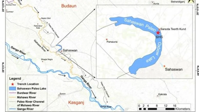
The research centered on a 3.3-meter-deep excavation into the bed of a desiccated oxbow lake. Oxbow lakes are U-shaped bodies of water formed when a wide meander from the main stem of a river is cut off, creating a free-standing lake. Because these lakes act as natural sediment traps, they preserve a chronological record of the environmental conditions present at the time of deposition.
The findings, published in Quaternary Science Reviews, suggest that the evolution of the Central Ganga Basin was dictated by a "tectono-climatic" duo: the movement of deep-seated fault lines and the erratic behavior of the Indian Summer Monsoon (ISM).
Key highlights of the study include:

- The Tectonic Trigger: The formation of the Sahaswan lake was not merely a result of gradual erosion but was triggered by activity along the Hathras-Sirauli Fault, a subsidiary of the Great Boundary Fault.
- River Avulsion: This tectonic movement forced the ancestral Mahawa River to abruptly abandon its course—a process known as avulsion—leaving behind the depression that became the lake.
- Climate Synchronization: The sedimentary layers perfectly mirror major global climatic events, including the Roman Warm Period and the Little Ice Age, showing how these global phenomena manifested locally in the Indian subcontinent.
- Societal Impact: The data provides a geological explanation for the eastward migration of the Indus Valley populations and the eventual economic decline of the Gupta Empire.
A Chronology of Change: 4,500 Years of History
The researchers reconstructed a timeline spanning from approximately 4,467 years ago to the present, revealing a landscape in constant flux.
The Era of Instability (4,200 – 3,200 Years Ago)
During this period, the region was characterized by severe, prolonged droughts. The Indian Summer Monsoon weakened significantly, leading to massive crop failures. This era coincides with the decline of the mature Harappan (Indus Valley) phase. As water sources in the west dried up, these ancient populations were forced to migrate toward the more reliable water sources of the Ganga Basin. However, even here, the Sahaswan data shows that life was a struggle against aridity.
The Golden Age and the Roman Warm Period (3,000 – 1,400 Years Ago)
As the climate shifted into what is known globally as the Roman Warm Period, the Central Ganga Basin entered a phase of abundant rainfall and agricultural prosperity. This period saw the rise of the Maurya and early Gupta empires. The consistent monsoons allowed for surplus grain production, which in turn fueled trade, urban development, and the flourishing of the arts and sciences—marking the "Golden Age of India."
The Dark Ages and the Little Ice Age (1,400 – 525 Years Ago)
The prosperity was not to last. Between 1,400 and 1,000 years ago, a phase known as the Dark Ages Cold Period took hold. The monsoon weakened, undermining the agrarian revenue that sustained the Gupta Empire. This climatic stress contributed to political fragmentation and economic deterioration.
By approximately 800 years ago, the Sahaswan lake began a terminal shrink. By the onset of the Little Ice Age (roughly 650 years ago), the monsoon had failed so consistently that the lake—once a thriving aquatic ecosystem—completely dried up, leaving behind the mud-filled depression studied by the team today.

Supporting Data: The Language of the Soil
To reach these conclusions, the scientific team employed a suite of high-tech analytical methods that turned common mud into a readable historical record.
Particle Size Analysis
The team sliced the 3.3-meter sediment core into 165 individual samples at 2-centimeter intervals. Using a laser particle size analyzer, they measured the grain size of the sediment.
- Coarse Sand: Indicated periods of high-energy water flow and heavy monsoon flooding, where fast-moving waters could carry heavier particles into the lake.
- Fine Clay and Silt: Indicated periods of drought or low-energy water, where only the finest particles settled in stagnant or receding pools.
Geochemical Fingerprinting
The researchers used X-ray fluorescence (XRF) to determine the elemental composition of the soil.
- Calcium (Ca) and Strontium (Sr): High levels of these elements pointed to warm, wet periods. These conditions encouraged the growth of shell-bearing aquatic organisms, which left behind calcium-rich remains.
- Rubidium (Rb): Higher concentrations of rubidium were found in layers corresponding to colder, drier climates. In these periods, chemical weathering slows down, and physical weathering—the mechanical breaking of rocks—dominates, concentrating elements like rubidium in the soil.
Carbon Isotopes and Radiocarbon Dating
By examining the carbon isotopes of organic matter within the layers, the team could identify what types of vegetation surrounded the lake. They distinguished between "C3" plants (which thrive in wet, temperate conditions) and "C4" plants (which are adapted to hot, arid environments).
To ensure the timeline was accurate, the researchers used Accelerator Mass Spectrometry (AMS) to radiocarbon-date fossilized shells and organic debris found at various depths. This provided a high-resolution calendar for the climatic shifts they observed.

Official Context and Scientific Consensus
The findings from Sahaswan add a critical piece to the puzzle of Indian paleoclimatology. Lead researchers from IIT Kharagpur emphasize that while previous studies often focused on marine sediments from the Arabian Sea or the Bay of Bengal, this study provides "ground truth" from the heart of the human settlements themselves.
"The Central Ganga Basin is one of the most densely populated regions on Earth and has been for millennia," noted the research team. "Understanding how this specific landscape responds to tectonic and climatic stress is not just an academic exercise; it is a matter of understanding the foundational stability of Indian civilization."
Geologists involved in the study pointed out that the Hathras-Sirauli Fault’s role in river avulsion is a significant discovery. It suggests that the "Great Boundary Fault" system remains a potent force in shaping the drainage patterns of Northern India, even in areas not typically associated with high-intensity earthquakes in the modern era.
Implications: Lessons for a Changing Future
The study arrives at a time when global climate change is once again threatening to disrupt the Indian Summer Monsoon. The Sahaswan records offer a sobering perspective on the vulnerability of agrarian societies to environmental shifts.
1. Water Security and Infrastructure
The history of the Mahawa River’s sudden course change (avulsion) serves as a warning for modern infrastructure planning. If deep tectonic activity can cause rivers to shift today, the placement of dams, bridges, and major cities must account for these rare but catastrophic geological events.
2. Agricultural Resilience
The correlation between the "Dark Ages Cold Period" and the fall of the Gupta Empire highlights how dependent India’s economy remains on the monsoon. As rainfall patterns become more erratic due to global warming, the study suggests that the survival strategies of the past—such as migration and shifting crop types—may need to be updated with modern technology to prevent similar societal collapses.
3. Understanding the "Human-Environment" Feedback Loop
The research proves that the "Golden Age" of Indian history was as much a product of favorable geology and climate as it was of political leadership. It underscores the fact that human history is inextricably linked to the earth’s natural cycles.
As the dried-up oxbow lake of Sahaswan yields its secrets, it provides more than just a look at the past; it offers a roadmap for the future. By understanding the triggers that once forced ancient civilizations to abandon their homes, modern India can better prepare its drinking water systems and agricultural policies for the environmental challenges of the 21st century.
In the words of the researchers, "The soil does not lie. It remembers the floods that brought life and the droughts that brought silence. Our task is to listen."
