

The Kuttanad region of Kerala, famously dubbed the “rice bowl” of the state, is currently a landscape in peril. A geographical marvel defined by its below-sea-level farming and labyrinthine backwaters, it represents a delicate intersection of natural generative power and destructive human ambition. While its unique integrated farming system is recognized globally by the Food and Agriculture Organization (FAO) as a Globally Important Agricultural Heritage System (GIAHS), the region is struggling under the weight of decades of ill-conceived engineering and environmental neglect.
Today, Kuttanad stands at a crossroads, where the very interventions designed to ensure food security have become the primary drivers of ecological collapse. From microplastic contamination to the invasive stranglehold of water hyacinth, the region’s distress is a stark reminder of the consequences of disrupting natural hydrological rhythms.
I. Main Facts: A Global Heritage Under Siege
Kuttanad is a low-lying deltaic region spanning approximately 1,100 square kilometers across the Alappuzha, Pathanamthitta, and Kottayam districts. Its defining characteristic is its elevation—or lack thereof—with much of the land lying 0.6 to 2 meters below sea level. This makes it one of the few places in the world where farming, particularly paddy cultivation, is carried out below sea level.
The Ecological Blueprint
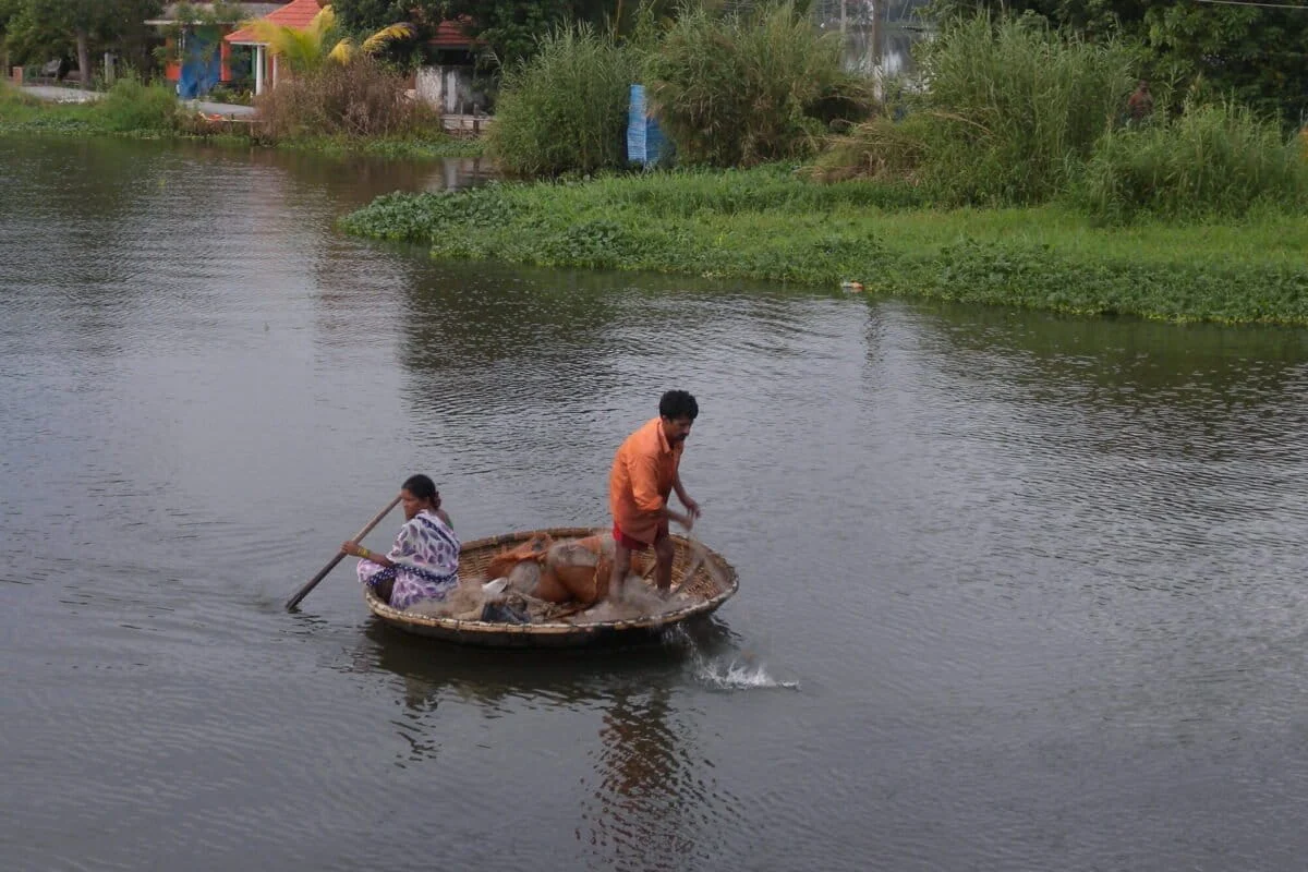
The region is fed by four major rivers—the Pampa, Achankovil, Manimala, and Meenachil—which drain into the Vembanad Lake, India’s longest lake and a designated Ramsar site. This ecosystem supports two primary livelihoods:
![A fertile landscape at the crossroads of ecology and development [Commentary]](https://imgs.mongabay.com/wp-content/uploads/sites/30/2026/08/03125249/4670487709_c95df8f47d_4k-scaled-e1785742237892-1200x800.jpg)
- Agriculture: 524 sq km of low-lying polders (padasekharams) reclaimed from the lake.
- Fisheries: A brackish-water system that serves as a nursery for shrimp, prawns, and the pearl spot (karimeen).
The Triple Threat
Kuttanad is currently battling a triad of environmental crises:
- Pollution: High levels of agricultural runoff and microplastic contamination.
- Flooding: Reduced lake capacity and clogged drainage channels leading to catastrophic inundations.
- Salinity: Disrupted tidal flows that threaten the sensitive rice crops while simultaneously destroying the brackish-water biodiversity.
II. Chronology: From Natural Equilibrium to Engineered Distress
The history of Kuttanad is a transition from a dynamic, self-regulating estuary to a heavily modified and fragmented landscape.
Geomorphological Origins (Pleistocene to Early 20th Century)
Geologically, Kuttanad is a young landscape. Originally a shallow coastal shelf of the Arabian Sea, it was formed over millennia as rivers from the Western Ghats deposited silt and alluvium. This process created the unique Kari (black) soil, a peaty, marshy earth rich in organic matter. Historically, the region fluctuated between freshwater during the monsoon and saline during the summer, a rhythm that supported a diverse range of aquatic life.
The "Grow More Food" Era (1940s–1960s)
Following India’s independence, the drive for food self-sufficiency led to massive land reclamation. Large portions of the Vembanad Lake were cordoned off with embankments (bunds) to create polders. This era saw the launch of the "Grow More Food" campaign, which prioritized rice acreage over the lake’s natural flood-absorption capacity.
![A fertile landscape at the crossroads of ecology and development [Commentary]](https://imgs.mongabay.com/wp-content/uploads/sites/30/2026/08/03131024/FARMERS_ENGAGED_IN_RICE_CULTIVATION_KUTTANAD-768x512.jpg)
The Engineering Interventions (1950s–1974)
Two major structures were built to "tame" the landscape:
- 1955: The Thottapally Spillway was commissioned to drain excess floodwater from the rivers directly into the sea.
- 1974: The Thanneermukkom Saltwater Regulator was constructed. This 1.2-km-long barrage was designed to block seawater intrusion during the summer, allowing farmers to grow a second crop of rice.
The Recognition and Crisis (2007–Present)
In 2007, the M.S. Swaminathan Research Foundation highlighted the region’s "agrarian distress." In 2013, the FAO designated the region as a GIAHS site. However, the 2018 Kerala floods served as a tragic confirmation that the region’s flood-management infrastructure was no longer fit for purpose.
III. Supporting Data: The Cost of Modernization
The environmental degradation of Kuttanad is backed by alarming empirical evidence.
Lake Shrinkage and Siltation
Human intervention has reduced the original expanse of Vembanad Lake by an estimated 65%. Concurrently, deforestation in the Western Ghats for tea and rubber plantations has accelerated soil erosion. The rivers now carry an immense sediment load that settles in the estuary, further reducing its depth and water-carrying capacity.
![A fertile landscape at the crossroads of ecology and development [Commentary]](https://imgs.mongabay.com/wp-content/uploads/sites/30/2026/08/03134717/IMG_0598-768x512.jpg)
The Microplastic Menace
Recent studies have revealed a silent killer in the Kuttanad waters: microplastics.
- Concentration: Sediments on the lake bed contain between 96 and 500 particles per square meter.
- Polymer Types: The water is heavily contaminated with Low-Density Polyethylene (LDPE), polypropylene, and nylon, largely derived from discarded fishing nets and household waste.
- Bioaccumulation: The native black clam, a staple for local communities and a major export, has been found to ingest these plastics, allowing toxins to enter the human food chain.
Ecological Fragmentation
The Thanneermukkom Regulator effectively split the Vembanad Lake into two distinct zones: a freshwater pool to the south and a saline lagoon to the north. This has resulted in:
- Extinction of Species: Migratory fish and prawns, which require varying salinity levels to breed, have virtually vanished from the southern reaches.
- Invasive Species: The lack of tidal flushing has allowed the Water Hyacinth (Eichhornia crassipes) to proliferate. These dense mats block sunlight, deplete dissolved oxygen, and create "dead zones" where no aquatic life can survive.
IV. Official Responses: Reports, Packages, and Implementation Gaps
The state and central governments have long been aware of Kuttanad’s decline, yet action has been characterized by "poor coordination among implementing agencies."
The Swaminathan Report (2007)
The most comprehensive roadmap for restoration was the report by Dr. M.S. Swaminathan. Key recommendations included:
![A fertile landscape at the crossroads of ecology and development [Commentary]](https://imgs.mongabay.com/wp-content/uploads/sites/30/2026/08/03140152/Thanneermukkom_Bund-768x512.jpg)
- Special Agricultural Zone (SAZ): Declaring Kuttanad a protected zone to halt further land reclamation.
- Infrastructure Modernization: Upgrading the Thottapally spillway and Thanneermukkom barrage to allow for more flexible water management.
- Integrated Farming: Encouraging "Rice-Fish" cultivation to restore the economic viability of the region without destroying the ecology.
The Kuttanad Package
Based on these recommendations, the Union Cabinet approved the ₹1,840-crore Kuttanad Package in 2008. While the package aimed to mitigate agrarian distress and restore the wetland, much of the funding was diverted to minor civil works rather than the fundamental ecological restoration suggested in the report. Consequently, the core issues of drainage and salinity balance remain unresolved.
Current Engineering Projects
The government continues to engage in deep-dredging and sand mining near the Thottapally spillway. While officials claim this is to increase discharge capacity, local environmentalists and residents argue that unscientific mining is altering wave energy patterns, leading to severe coastal erosion and threatening the very boundaries that protect Kuttanad from the sea.
V. Implications: A Paradigm Shift Toward Resilience
The ongoing crisis in Kuttanad suggests that the "command and control" approach to nature has reached its limit. The implications for the future are both a warning and a call for innovation.
The Case for Decommissioning
There is a growing consensus among ecologists that the state must reconsider the continued operation of the Thanneermukkom and Thottapally structures. Decommissioning or radically altering their operation to allow natural tidal flows could:
![A fertile landscape at the crossroads of ecology and development [Commentary]](https://imgs.mongabay.com/wp-content/uploads/sites/30/2026/08/03141008/4474670009_1a2d6ac01c_5k-768x512.jpg)
- Naturally control water hyacinth through salinity.
- Revive the estuarine fish and clam populations.
- Restore the lake’s ability to self-flush pollutants and sediments.
The Circular Economy Opportunity
The water hyacinth, currently a "menace," could be transformed into a source of local employment. By incentivizing the collection of the weed, the state could foster industries for:
- Organic Manure: Replacing chemical fertilizers that currently pollute the polders.
- Handcrafted Products: Processing the fiber into paper, boards, and textiles.
- Bio-gas: Utilizing the high organic content for renewable energy.
Tourism vs. Ecology
As Kuttanad becomes a hub for mass tourism, the discharge of untreated sewage from thousands of houseboats poses a terminal threat. Without strict regulations and the implementation of zero-discharge systems, the "green beauty" that attracts tourists will soon become a toxic marsh, destroying the very asset the tourism industry relies upon.
Conclusion
Kuttanad’s story is a poignant parable of human ambition clashing with ecological limits. The agricultural bounty achieved through heroic engineering in the 20th century has sown the seeds of 21st-century distress. To secure a future for the "rice bowl," Kerala must move away from concrete walls and toward a holistic management of its hills, rivers, and sea. Only by restoring the natural rhythms of the Vembanad system can Kuttanad regain its resilience and remain a heritage for generations to come.
