

HYDERABAD — Deep beneath the stable, ancient crust of Eastern India lies a hidden world of recycled oceans and vast reservoirs of water, trapped for millions of years. A groundbreaking study led by the CSIR-National Geophysical Research Institute (CSIR-NGRI) has provided the most detailed map to date of the Earth’s interior under the Eastern Indian craton, uncovering a "geological engine" that has driven the evolution of the subcontinent for billions of years.
The research, spearheaded by Dr. Prantik Mandal, reveals that the Mantle Transition Zone (MTZ)—a critical layer located hundreds of kilometres beneath the states of Odisha and Jharkhand—contains evidence of stagnant tectonic slabs and volatile-rich pockets. These findings offer a rare glimpse into the deep-earth processes that shaped the assembly of supercontinents and continue to influence the tectonic stability of the region today.
Main Facts: A Window into the Deep Earth
The Earth is often compared to an onion, with layers of varying density and composition. While the crust is the thin skin we inhabit, the mantle makes up the bulk of the planet’s volume. The new study focuses on the Mantle Transition Zone (MTZ), a region situated between 410 and 660 kilometres below the surface. This zone acts as a gateway, regulating the flow of heat and material between the upper and lower mantle.
Key Discoveries:
- Trapped Reservoirs: The study identifies "low-velocity layers" just above the 410 km and 660 km boundaries. These layers suggest the presence of water-saturated minerals or partially melted rock.
- Ancient Ocean Remnants: Evidence of "stagnant slabs"—fragments of ancient oceanic lithosphere that were pushed deep into the earth (subducted) millions of years ago—was found piling up at the base of the transition zone.
- Water Content: The research estimates that the MTZ beneath Eastern India holds between 0.1% and 0.3% water by weight. While seemingly small, across the vast volume of the mantle, this represents a massive deep-earth reservoir.
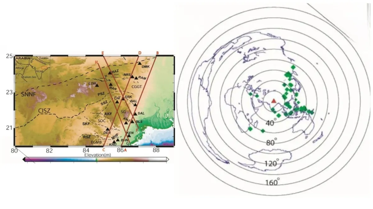
- Technological Precision: Using a network of 16 broadband seismic stations and analyzing 666 specific seismic wave conversions, researchers achieved unprecedented resolution of the craton’s deep structure.
Chronology: From Ancient Cratons to Modern Collisions
To understand the significance of these findings, one must look back at the geological history of the Indian subcontinent. The Eastern Indian Craton, also known as the Singhbhum-Odisha Craton, is one of the oldest fragments of Earth’s continental crust, with some sections dating back over 3.5 billion years.
The Assembly of Gondwana
Roughly 550 million years ago, the Earth’s landmasses were merging to form the supercontinent Gondwana. During this colossal assembly, oceanic plates were forced beneath the continental fragments. The research suggests that much of the water and tectonic debris currently trapped beneath Eastern India may have been "injected" into the mantle during this period.

The Himalayan Collision
More recently (geologically speaking), about 50 million years ago, the Indian plate began its high-speed collision with the Eurasian plate, a process that created the Himalayas and continues today. This ongoing tectonic pressure has further influenced the movement of material in the mantle. The stagnant slabs identified in the MTZ may be remnants of the Tethys Ocean floor, which disappeared as India moved northward.
The Modern Study
Dr. Mandal’s study represents the culmination of years of seismic monitoring. By deploying high-sensitivity equipment across the rugged terrains of Odisha and Jharkhand, the team was able to capture the echoes of global earthquakes, using them as a "geological ultrasound" to peer into the depths that have remained a mystery for decades.
Supporting Data: The Science of Seismic Imaging
The primary tool used in this discovery is P-receiver function imaging. This technique relies on the behavior of seismic waves generated by large earthquakes occurring elsewhere in the world.
How Seismic Mapping Works
When an earthquake occurs, it sends primary (P) waves and secondary (S) waves through the Earth. As these waves encounter major geological boundaries—such as the transition from one mineral phase to another—they change speed and partially convert from one type to another (e.g., a P-wave converting to an S-wave).
By measuring the time delay between these converted waves, Dr. Mandal was able to calculate the exact depth of two critical discontinuities:

- The 410-km Discontinuity: Where the mineral olivine transforms into wadsleyite.
- The 660-km Discontinuity: Where minerals transform into the even denser bridgmanite.
The Anomaly of Speed
The study found that the MTZ beneath Eastern India is approximately 235 kilometres thick, which aligns with the global average. However, the seismic waves slowed down significantly in specific pockets. In the world of geophysics, "slow" usually means "soft" or "fluid."
The presence of these low-velocity zones (LVZs) is a strong indicator of:
- Hydrous Minerals: Minerals like wadsleyite and ringwoodite can hold significant amounts of water in their crystal structure.
- Partial Melt: High temperatures combined with the presence of volatiles (like water and CO2) can cause rock to begin melting even at extreme depths.
Official Responses and Scientific Nuance
While the findings are a major milestone for Indian geophysics, Dr. Prantik Mandal and the CSIR-NGRI team maintain a tone of professional caution. In the study, it is noted that interpreting seismic data is a complex mathematical challenge.
The Challenge of Interpretation
"While the low-velocity layers are a compelling explanation for the data, they are not yet a certainty," the researchers noted. There are two primary alternative explanations for the "slow" seismic signals:
- Anisotropy: This occurs when minerals are aligned in a specific direction (much like the grain in wood), causing waves to travel faster in one direction than another. If the minerals in the MTZ are highly aligned, it could mimic the signature of water or melt.
- Processing Artifacts: The mathematical models used to process 666 wave conversions are incredibly sensitive. Minor errors in calculation could potentially create "ghost" structures in the data.
The Path Forward: Magnetotellurics
To confirm the presence of water, the scientific community is looking toward magnetotellurics (MT). This method measures the Earth’s natural electrical conductivity. Since water and melt conduct electricity much more efficiently than solid rock, an MT survey could provide the "smoking gun" needed to prove that Eastern India sits atop a deep-earth reservoir.

Implications: Stability, Climate, and Habitability
The discovery of water and ancient tectonic debris beneath the Eastern Indian craton has implications that reach far beyond the field of geology.
1. Continental Stability and Earthquake Prediction
Cratons are the "anchors" of the continents. They are cold, thick, and stable. However, the discovery of water and recycled slabs suggests that the "roots" of the Eastern Indian craton are more dynamic than previously thought. Understanding how these deep structures interact with the crust helps geologists predict how the region will respond to the immense tectonic stresses imposed by the Himalayan collision, potentially aiding in long-term seismic risk assessment.
2. The Deep-Water Cycle
We are familiar with the surface water cycle (evaporation, rain, rivers), but the Deep-Water Cycle is equally important for the planet’s health. The movement of water into the mantle via subduction and its eventual release through volcanic activity regulates the Earth’s internal temperature and the composition of the atmosphere.
If the MTZ acts as a massive storage tank for water, as this study suggests, it means the Earth’s interior has a much higher capacity to store volatiles than previously estimated. This storage regulates volcanic activity over millions of years, which in turn influences the long-term climate and the habitability of the planet.
3. A Record of Lost Oceans
The "stagnant slabs" identified under Odisha and Jharkhand are essentially a graveyard of ancient oceans. By studying these slabs, scientists can reconstruct the size and location of seas that haven’t existed for half a billion years. It allows researchers to map the "conveyor belt" of plate tectonics in three dimensions, showing not just where the plates are moving on the surface, but where they go after they "die."

Conclusion
The work of Dr. Prantik Mandal and the CSIR-NGRI provides a new lens through which to view the Indian subcontinent. Far from being a static block of stone, the ground beneath Eastern India is revealed to be a complex, layered archive of the planet’s history. As researchers continue to probe these depths, they are uncovering the ancient forces that built the land we walk on and the hidden processes that continue to sustain its stability.
By mapping these deep foundations, India takes a leading role in the global effort to understand the inner workings of our "living" planet—a world where the remains of ancient oceans and the seeds of future tectonic shifts lie hidden 600 kilometres beneath the surface.
