

HYDERABAD — Beneath the seemingly immovable landscapes of Odisha and Jharkhand lies a geological mystery billions of years in the making. New research from the CSIR-National Geophysical Research Institute (CSIR-NGRI) has pulled back the curtain on the Earth’s deep interior, revealing a complex subterranean architecture that includes the remnants of ancient oceans and massive, trapped reservoirs of water.
By utilizing advanced seismic imaging techniques, scientists have mapped the "Mantle Transition Zone" (MTZ) beneath the Eastern Indian craton—a stable fragment of the Earth’s crust that has survived for over three billion years. The findings, led by Dr. Prantik Mandal, offer a rare glimpse into the "stagnant slabs" of long-lost tectonic plates and suggest that the deep earth beneath India holds significantly more water than previously estimated.
Main Facts: Deciphering the Depths of the Singhbhum-Odisha Craton
The study focuses on the Eastern Indian craton, specifically the Singhbhum-Odisha region, which serves as a geological anchor for the Indian subcontinent. Unlike younger crustal regions, cratons are thick, cold, and remarkably stable, making them ideal "windows" through which to observe the deeper mantle.
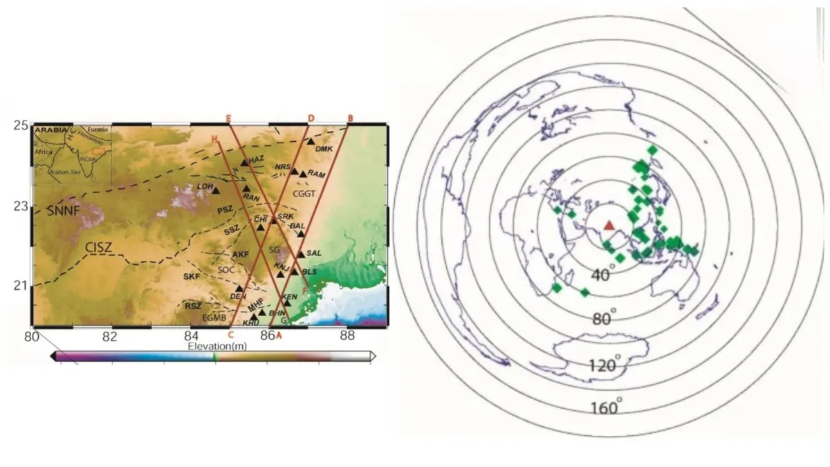
Using a sophisticated network of 16 broadband seismic stations strategically placed across Odisha and Jharkhand, Dr. Mandal and his team performed a high-resolution "ultrasound" of the Earth. The primary focus was the Mantle Transition Zone, a critical layer located between 410 and 660 kilometers below the surface. This zone acts as a gateway between the upper and lower mantle, where extreme pressure forces minerals to change their physical structure.
The research yielded three primary breakthroughs:

- MTZ Dimensions: The transition zone beneath Eastern India is approximately 235 kilometers thick, aligning closely with global averages but displaying unique local anomalies.
- Hydration Signatures: The data indicates the presence of 0.1% to 0.3% water by weight within the minerals of the transition zone. While these percentages seem small, the sheer volume of the MTZ means this represents a massive deep-earth water reservoir.
- Ancient Ocean Remnants: The mapping identified "stagnant slabs"—fragments of ancient oceanic lithosphere that were pulled into the Earth’s interior (subducted) millions of years ago and are now resting at the base of the transition zone.
Chronology: A 3-Billion-Year Geological Odyssey
To understand the significance of these findings, one must look at the chronological evolution of the Indian plate. The Eastern Indian craton is one of the oldest pieces of Earth’s crust, with some sections dating back 3.2 to 3.5 billion years.
The Era of Craton Formation (3.5 – 2.5 Billion Years Ago)
During the Archean Eon, the Singhbhum-Odisha craton formed through intense volcanic activity and the gradual cooling of the Earth’s early mantle. This "lithospheric keel" provided the stability needed for the continent to grow.
The Assembly of Gondwana (~550 Million Years Ago)
The study suggests that some of the water and recycled crust found in the MTZ may have been introduced during the assembly of the supercontinent Gondwana. As various landmasses collided to form this massive continent, oceanic plates were forced deep into the mantle, carrying water-rich minerals with them.
The Himalayan Collision (50 Million Years Ago to Present)
The most recent major chronological event impacting the region’s deep structure is the collision between the Indian and Eurasian plates. As India continues to push northward, the stresses and material recycling associated with this collision have likely contributed to the "stagnant slabs" currently piling up beneath the Indian plate. The research posits that the MTZ acts as a graveyard for these slabs, preventing them from sinking immediately into the lower mantle.
Supporting Data: The Physics of Seismic Imaging
The methodology employed by Dr. Mandal, known as P-receiver function imaging, relies on the behavior of seismic waves generated by distant earthquakes. When a P-wave (primary wave) encounters a sharp change in density or composition—such as the boundaries of the MTZ—a portion of its energy is converted into an S-wave (secondary wave).

The 410 and 660 Discontinuities
The researchers analyzed 666 of these wave conversions. The "410-km discontinuity" marks the depth where the mineral olivine transforms into wadsleyite. The "660-km discontinuity" marks the transition from wadsleyite to bridgmanite.
The study found "low-velocity layers" (LVLs) sitting directly above these boundaries. In seismology, a drop in wave velocity usually indicates the presence of:
- Partial Melt: Rock that has begun to liquefy due to temperature or chemical changes.
- Volatiles: Elements like water or carbon dioxide that lower the melting point of rock and slow down seismic waves.
The data revealed that these LVLs are particularly pronounced beneath the Eastern Indian craton, providing the strongest evidence yet for a hydrated mantle transition zone in this specific region.
Comparative Thickness
While the global average thickness of the MTZ is roughly 250 km, the 235-km thickness observed here suggests a slightly warmer-than-average mantle or a specific chemical composition influenced by the presence of recycled oceanic material.
Official Responses and Scientific Perspective
Dr. Prantik Mandal’s work has been met with significant interest within the geophysics community, though the researcher himself maintains a tone of scientific caution. In the study, it is noted that while the "water-tank" theory is the most compelling explanation for the low-velocity layers, it is not the only possibility.

"The dips in seismic speed could also be explained by the alignment of minerals in the rock, a phenomenon called anisotropy," the study notes. Alternatively, some of the data could be "artifacts created during the complex mathematical processing of the seismic signals."
To achieve absolute certainty, the CSIR-NGRI team suggests that future research must integrate magnetotellurics. This method measures the Earth’s electrical conductivity. Since water-saturated rocks conduct electricity far better than dry rocks, a magnetotelluric survey would provide the "smoking gun" needed to confirm the volume of water trapped 600 kilometers below Odisha.
Official bodies within the Indian scientific community have highlighted that this study represents the first time such high-density seismic data has been collected specifically for the Eastern Indian craton’s deep structure. Previous models relied on broader, less precise global data sets.
Implications: Why the Deep Earth Matters to the Surface
The discovery of water and ancient crustal remains beneath Eastern India is not merely a matter of academic curiosity; it has profound implications for our understanding of the planet’s long-term viability and the stability of the Indian subcontinent.
1. The Deep-Water Cycle and Habitability
The Earth is unique among known planets because it recycles its water. Subduction zones carry water from the oceans into the mantle, and volcanic activity eventually returns it to the atmosphere as steam. By mapping the reservoirs in the MTZ, scientists can better understand the "Earth’s budget" of volatiles. This cycle regulates the atmosphere and ensures the planet remains habitable over billions of years.

2. Tectonic Stability and Earthquake Prediction
Cratons are the "anchors" of the continents. Understanding the thickness and temperature of the MTZ beneath the Singhbhum-Odisha region helps geologists predict how the Indian plate will respond to the ongoing pressure of the Himalayan collision. A "soft" or hydrated mantle might behave differently under stress than a "dry" or rigid one, affecting how tectonic energy is distributed across the plate, potentially influencing intra-plate seismic activity.
3. Mineral and Resource Exploration
While the MTZ is far too deep to mine, the processes that occur there—specifically the movement of fluids and melts—drive the formation of mineral deposits in the upper crust over millions of years. Understanding the "engine room" of the craton provides clues to the location of rare minerals and ores that were pushed toward the surface during ancient tectonic events.
4. A Record of Earth’s History
The "stagnant slabs" identified in this study are essentially a fossilized record of the Tethys Ocean and other prehistoric seas. By studying these remains, scientists can reconstruct the movement of continents with much higher accuracy, providing a clearer picture of how the map of the world has changed and will continue to change.
Conclusion
The research conducted by Dr. Prantik Mandal and the CSIR-NGRI provides a masterclass in modern geophysics, turning the ground beneath Eastern India into a transparent laboratory. The revelation of a 235-kilometer-thick Mantle Transition Zone, enriched with the moisture of ancient oceans and the debris of lost tectonic plates, reminds us that the Earth is a dynamic, recycling machine.
As India continues its slow-motion collision with Asia, the deep structures mapped in this study will play a pivotal role in determining the geological future of the subcontinent. For now, the residents of Odisha and Jharkhand walk upon a land that hides a vast, subterranean ocean—a silent witness to the ancient forces that built the world.
