

By [Your Publication Name] Science Desk
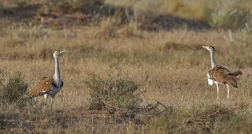
In the vast, sun-drenched stretches of the Deccan Plateau, a silent tragedy has been unfolding for decades. The Great Indian Bustard (Ardeotis nigriceps), a bird of such regal stature that it stands nearly a meter tall and ranks among the heaviest flying creatures on the planet, is vanishing. Once the undisputed monarch of the Indian grasslands, roaming across 11 states and into the heart of Pakistan, the species has seen its kingdom shrink to a few fragmented outposts.
Today, the global population has plummeted to fewer than 150 individuals. While the most stable population resides in the Thar Desert of Rajasthan, the southernmost populations—scattered across Maharashtra, Karnataka, Telangana, and Andhra Pradesh—are teetering on the precipice of local extinction.
However, a landmark study by scientists at the Wildlife Institute of India (WII) has provided a glimmer of hope. By synthesizing cutting-edge satellite telemetry with boots-on-the-ground ecological surveys, researchers have identified 16 high-priority conservation zones. These zones, spanning approximately 18,000 square kilometers, represent the "last stand" for the Great Indian Bustard (GIB) in the semi-arid Deccan landscape.
Main Facts: A Species in Peril and the 6.6% Reality
The WII investigation reveals a startling geographical reality: out of the 720,000 square kilometers that comprise the Deccan Plateau, only a mere 6.6 percent remains suitable habitat for the GIB. This narrow margin of survival underscores the extreme specialization of the bird and the intensity of human encroachment.
The Great Indian Bustard is a "specialist" species. Unlike more adaptable birds, the GIB requires a delicate mosaic of open, natural grasslands and low-intensity, traditional agricultural fields. The study, which utilized Maximum Entropy (MaxEnt) distribution modeling, highlighted that the bird’s presence is dictated by specific environmental cues. Seasonal rainfall patterns—particularly during the scorching summer months—and the moderate "greening" of vegetation at the onset of the monsoon are the primary factors that determine where these birds can survive.
Crucially, the research confirms that the GIB is an "avoidance" species. They shun dense forests and heavily urbanized centers, preferring wide-open vistas where they have a 360-degree view of potential predators. These open spaces are also essential for their elaborate courtship displays, where males inflate a gular pouch to produce a low-frequency resonance that can be heard for miles—a haunting call that is increasingly falling on deaf ears in the modern Indian landscape.
Chronology: From Widespread Presence to Fragmented Pockets
The decline of the GIB is not a recent phenomenon but an accelerated one. Historically, the bird was a common sight across the semi-arid plains of India. However, the mid-20th century marked the beginning of a sharp downward trajectory.
- Pre-1970s: The GIB was found across much of the Indian subcontinent. Hunting and initial habitat loss began to thin the numbers, but the population remained viable in multiple states.
- 1980s – 1990s: India established several dedicated sanctuaries, such as Nannaj in Maharashtra and Rollapadu in Andhra Pradesh. At the time, these "fortress conservation" models were seen as the gold standard.
- 2000s – 2010s: Despite the existence of sanctuaries, populations continued to crash. It became evident that the GIB—a wide-ranging bird—could not be "fenced in." They frequently moved outside protected boundaries into agricultural lands, where they met new threats.
- 2020 – Present: The realization that fewer than 150 birds remain triggered a shift in scientific focus. The WII study represents the culmination of this shift, moving away from static park boundaries toward a "landscape-level" conservation strategy.
This latest research marks a turning point. By moving the focus from "where the birds are protected" to "where the birds actually go," scientists are finally aligning conservation policy with the biological reality of the species.
Supporting Data: GPS Telemetry and the "Wasteland" Myth
The strength of the WII study lies in its rigorous methodology, which combined high-tech data with traditional local knowledge.
The Precision of GPS Tagging
Unlike previous studies that relied on opportunistic sightings—which are often biased toward areas where humans are most active—this study utilized precise GPS telemetry. By tracking three wild-captured birds (a small but vital sample given the species’ rarity), researchers were able to map fine-scale habitat preferences. This data revealed that the birds frequently utilize "fallow" lands—fields left unplanted for a season—and native grasslands that are often overlooked by developers.
The Massive Field Campaign
To validate the digital models, 30 survey teams conducted a sweep across 372 grid cells in Maharashtra. While the birds themselves are so elusive that they were not spotted during these specific field sweeps, the teams interviewed 1,400 local villagers. This "Local Ecological Knowledge" (LEK) proved invaluable, confirming recent sightings in 72 key areas.
The Agricultural Shift
Data collected during the study highlights a primary driver of the GIB’s decline: the transformation of the agrarian economy. Traditionally, farmers in the Deccan grew pulses and oilseeds—crops that require little water and leave plenty of space for ground-nesting birds. Today, these have been replaced by high-intensity cash crops like sugarcane and cotton.
- Sugarcane: Grows tall and dense, making it impossible for a ground-nesting bird to navigate or spot predators.
- Cotton: Requires heavy pesticide use, which decimates the insect populations (grasshoppers and beetles) that the GIB relies on for food.
Furthermore, the study takes aim at the official classification of grasslands as "wastelands." This administrative label has historically allowed the government to divert these vital ecosystems for industrial use, solar parks, or afforestation programs—the latter of which involves planting trees in grasslands, effectively destroying the habitat for the GIB.
Official Responses and Policy Recommendations
While the WII study is a scientific document, its implications for government policy are profound. The researchers have presented a spatial roadmap that demands a coordinated response across four state governments: Maharashtra, Karnataka, Telangana, and Andhra Pradesh.
Beyond Sanctuary Walls
The study’s findings suggest that the current "Protected Area" (PA) network is insufficient. Because the GIB ranges across massive human-dominated mosaics, the WII recommends a "dynamic management" approach. This involves incentivizing farmers within the 16 identified zones to maintain traditional dryland farming practices and keep fields fallow during nesting seasons.
The Infrastructure Dilemma
A significant portion of the official dialogue sparked by this research concerns "green on green" conflict. The Deccan is a prime location for solar and wind energy. However, the high-voltage power lines required to transport this energy are a leading cause of GIB mortality, as the birds have poor frontal vision and cannot see the wires until it is too late. The WII framework provides policymakers with a blueprint to relocate or underground these lines in the 18,000 square kilometers identified as high-priority zones.
Cross-Border Coordination
Implementing this plan requires a level of interstate cooperation rarely seen in Indian conservation. The WII has called for a unified policy that standardizes land-use regulations across state lines, ensuring that a "safe zone" in Karnataka doesn’t end abruptly at the Andhra Pradesh border.
Implications: A Flagship for the "Open Natural Ecosystems"
The effort to save the Great Indian Bustard is about much more than a single species. The GIB is a "flagship species" for India’s Open Natural Ecosystems (ONE). These semi-arid landscapes—grasslands, scrublands, and thorn forests—are often dismissed as unproductive, yet they are biological powerhouses.
Biodiversity Co-benefits
By protecting the 18,000 square kilometers of GIB habitat, we are effectively protecting an entire guild of threatened wildlife. The grey wolf, the Indian fox, the blackbuck, and the lesser florican all share the same habitat. When the GIB thrives, the entire Deccan food web is stabilized.
Sustainable Human Livelihoods
The study highlights a rare "win-win" scenario for humans and wildlife. The practices that benefit the GIB—low-intensity dryland farming—are the same practices that ensure long-term soil health and water security for farmers. In an era of climate change and depleting groundwater, moving away from thirsty crops like sugarcane in semi-arid regions is not just an ecological necessity; it is an economic one. Protecting grasslands also supports pastoral communities who rely on these lands for sustainable grazing.
A Legacy at Stake
Ultimately, the WII’s research provides a choice. We can continue to view the Deccan Plateau as a "wasteland" to be exploited, or we can see it as a complex, living landscape that supports a unique part of India’s natural heritage.
The 16 high-priority zones identified by the Wildlife Institute of India are not just lines on a map; they are the final boundaries between existence and extinction for the Great Indian Bustard. The science is clear, the roadmap is drawn, and the urgency is absolute. Whether this iconic bird will continue to perform its ancient courtship dance on the Deccan plains now rests in the hands of the policymakers and the communities who share its home.
