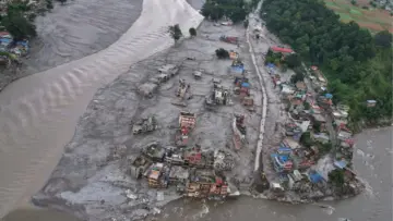
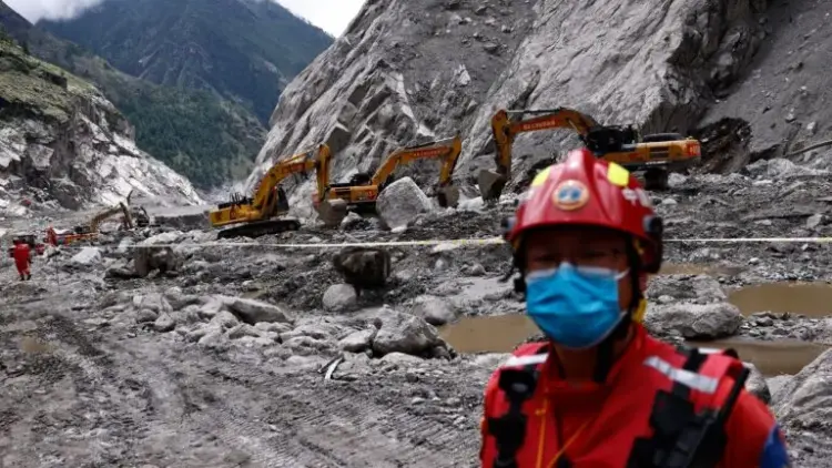
KATHMANDU / NEW DELHI – In the autumn of 2026, the fragile geography of the Hindu Kush-Himalayas was struck by a pair of catastrophic events that have forced a reckoning within the global scientific community. As flash floods and debris flows devastated the Gorkha district of Nepal, a breakthrough in satellite observation has suggested that these "unpredictable" disasters may actually leave measurable fingerprints weeks before they occur.
Main Facts: A Region Under Siege
The central crisis involves two distinct but geologically related disasters in Nepal’s high-altitude river basins. On August 26, 2026, a massive collapse of rock and glacial ice occurred on Langtang Lirung, a prominent peak in the central Himalayas. This collapse triggered a debris flow that surged through the Gyirong-Rasuwa corridor, a vital trade and transit route on the Nepal-China border.
Less than seven weeks later, on October 11, 2026, the Budhi Gandaki river basin in the Gorkha district was ravaged by a flash flood. The torrent, laden with sediment and boulders, decimated infrastructure, destroyed homes, and left hundreds of families displaced.
The "enriching" discovery, however, comes from the International Centre for Integrated Mountain Development (ICIMOD). In a synthesis report released shortly after the second disaster, scientists revealed that two advanced radar satellites—the European Union’s Sentinel-1 and the NASA-ISRO Synthetic Aperture Radar (NISAR)—had detected measurable ground displacement on the slopes of Langtang Lirung nearly a month before it collapsed. This finding has ignited a global debate: Can space-based radar be transformed from a post-disaster diagnostic tool into a proactive early warning system?

Chronology of the 2026 Himalayan Disasters
The timeline of the 2026 disasters illustrates a pattern of "cascading hazards," where one geological failure triggers a chain reaction of destruction downstream.
- July 7 – August 24, 2026: Sentinel-1 radar begins recording subtle shifts on the high-altitude slopes of Langtang Lirung. Over this period, the ground moves by approximately 40 centimeters along the satellite’s line of sight.
- July 26 – August 19, 2026: The NISAR satellite, utilizing its multi-band radar capabilities, confirms these observations, recording up to 30 centimeters of displacement in the same vicinity.
- August 26, 2026: The Langtang Lirung slope fails. Millions of cubic meters of rock and glacier ice plummet, transforming into a high-velocity surge of ice and debris. The flow strikes the Gyirong-Rasuwa corridor, causing significant damage to the border infrastructure and local settlements.
- September 2026: Relief operations continue amid heavy monsoon remnants. Scientists begin analyzing the "pre-event" satellite data, discovering the signals of instability that preceded the collapse.
- October 11, 2026: A secondary disaster strikes the Budhi Gandaki river basin. A flash flood, potentially exacerbated by previous slope instabilities and intense localized rainfall, tears through Gorkha district, destroying roads and rendering many homeless.
- Late October 2026: ICIMOD releases its synthesis report, highlighting the pre-failure movement and calling for a regional integrated monitoring system.
Supporting Data: The Science of InSAR and Satellite Radar
The ability to "see" a mountain moving from hundreds of kilometers in space relies on a technique known as Synthetic Aperture Radar Interferometry (InSAR). Unlike optical satellites, which are often blinded by the thick monsoon clouds of the Himalayas, radar satellites emit signals that penetrate weather and darkness.
The Sentinel-1 Constellation
The European Space Agency’s (ESA) Sentinel-1 mission uses C-band radar with a wavelength of 5.5 cm. This shorter wavelength is highly sensitive to surface changes but can sometimes be "noisy" in areas with dense vegetation. However, on the bare rock and ice of the high Himalayas, it provides high-resolution data on surface deformation.
The NISAR Mission
A joint venture between NASA and the Indian Space Research Organisation (ISRO), NISAR is a game-changer for mountain geography. It carries two radar systems:

- L-band (NASA): A 25-cm wavelength signal that can penetrate deeper into snow and ice, providing a clearer picture of the underlying rock stability.
- S-band (ISRO): A 10-cm wavelength signal that complements the L-band by providing finer detail on surface roughness.
By comparing radar images taken at different times (interferometry), scientists can measure ground movement with millimeter-level precision. The 30–40 cm of movement detected at Langtang Lirung was, in geological terms, a "scream" of impending failure.
The "Snowball" Effect of Debris Flows
Data from the Gyirong-Rasuwa disaster suggests that the initial collapse was only the beginning. As the mass of ice and rock moved downhill, it engaged in "entrainment"—picking up loose sediment and glacial till. This added mass increased the flow’s momentum, turning a localized slope failure into a regional flood disaster. ICIMOD scientists noted that as glaciers retreat due to global warming, they leave behind vast quantities of loose, unstable debris that act as fuel for these destructive surges.
Official Responses and Technical Challenges
The revelation that satellites "saw" the disaster coming has prompted a mix of optimism and caution from officials and the scientific community.
Chaitra Rao, NISAR Project Director at ISRO, Bengaluru, emphasized the strategic value of these assets. "The satellite can be programmed to look specifically at a land area of interest. Later it can look again to see how much it has changed," she told Mongabay India. However, she acknowledged the "big data" challenge: the sheer volume of observations is enormous, making it difficult to monitor every unstable slope in the 3,500-kilometer Himalayan range simultaneously.

Prashant Baral, a cryosphere analyst at ICIMOD, warned against viewing satellite data as a "silver bullet." He pointed out several critical limitations:
- Latency: There is often a delay between the satellite capturing data and the processing of that data into a readable format.
- Geometry: The steep, "v-shaped" valleys of the Himalayas can create radar shadows where the signal cannot reach.
- False Positives: Not every slope that moves will collapse. Distinguishing between "creep" (slow, stable movement) and "acceleration" (pre-collapse movement) requires expert interpretation.
Abhilash S., Head of Atmospheric Sciences at Cochin University, noted that the human element is just as important as the technology. "Real-time monitoring systems should be developed to track glacier movement, lake levels, and river levels. But these must be integrated with local monitoring systems and clear evacuation protocols," he said.
Implications: A New Era of Transboundary Cooperation
The 2026 disasters have highlighted a glaring gap in mountain safety: the lack of transboundary data sharing. The Himalayas, often called the "Third Pole," are shared by Afghanistan, Pakistan, India, Nepal, Bhutan, China, and Bangladesh. A disaster starting at a glacier in China can destroy a village in Nepal or a hydropower plant in India within hours.
The Hydropower Risk
The Budhi Gandaki and Langtang regions are hubs for ambitious hydropower projects. The October 11 flood serves as a stark reminder that these multi-billion-dollar investments are at the mercy of geological instability. Without a satellite-based early warning system, the economic viability of Himalayan hydro-energy remains in jeopardy.

Climate Change as a Catalyst
The retreat of glaciers is no longer just an environmental concern; it is a direct threat to life. As ice thaws, it destabilizes the "glue" that holds mountain slopes together. The ICIMOD report suggests that rock-and-ice collapses may now occur without extreme weather triggers, simply because the internal stability of the mountains has reached a breaking point due to gradual warming.
The Way Forward: An Integrated Regional System
The consensus among experts is that the Himalayas require an "Integrated Regional System." This would involve:
- Continuous Screening: Using satellites like NISAR and Sentinel-1 to identify "hotspots" of movement.
- Ground Truth-ing: Deploying GNSS (Global Navigation Satellite System) sensors and seismic instruments on those identified hotspots.
- Automated Alerts: River gauges and cameras that can track a debris flow in real-time and trigger sirens in downstream communities.
- Diplomatic Protocols: Formal agreements between Himalayan nations to share satellite and river-flow data in real-time, bypassing political friction for the sake of disaster risk reduction.
As Nepal continues to rebuild from the Budhi Gandaki floods, the focus has shifted from the ground to the stars. The 40 centimeters of movement detected before the Langtang Lirung collapse may well be the most important measurement in the history of Himalayan disaster management—a signal that, for the first time, we may have the tools to see the next disaster before it strikes.