
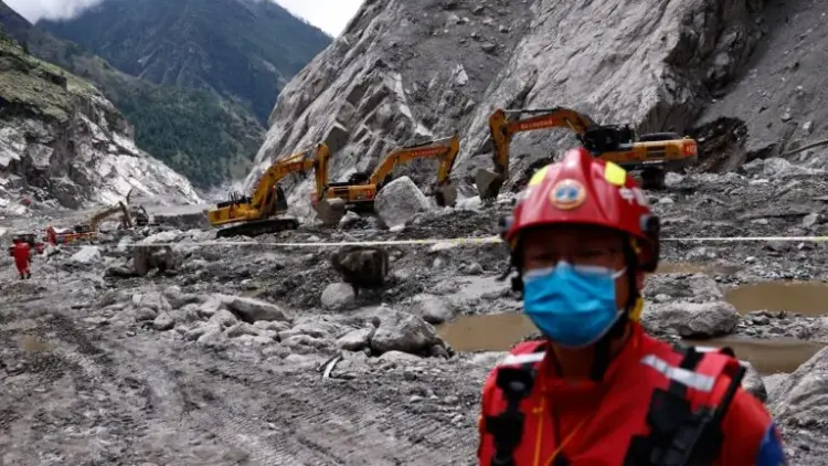
On October 11, 2026, the silence of the Gorkha district in Nepal was shattered by the roar of the Budhi Gandaki River. A massive flash flood, laden with thick sediment and mountain debris, tore through the basin, obliterating homes, severing vital road links, and leaving hundreds of families homeless in its wake. For a nation still reeling from a similar disaster less than two months prior, the event was a grim reminder of the increasing volatility of the Hindu Kush-Himalayan (HKH) region.
The disaster struck just seven weeks after the catastrophic collapse of rock and glacier ice on Langtang Lirung on August 26, 2026. That earlier event unleashed a surge of ice and debris through the Gyirong-Rasuwa corridor, a critical trade artery along the Nepal-China border. As emergency crews struggled to provide relief to the displaced, a group of scientists was preparing to release a synthesis report that could change the future of disaster management: satellite signals had captured the mountain’s "warning cries" weeks before it actually fell.
The central question now facing the scientific community and regional governments is whether these "clairvoyant" satellite observations can be transformed into a reliable, operational early-warning system to save lives in one of the world’s most treacherous terrains.
I. Main Facts: The Revelation of Pre-Collapse Deformation
The International Centre for Integrated Mountain Development (ICIMOD) recently released a synthesis report detailing a breakthrough in remote sensing. According to the report, two separate satellite systems detected measurable ground displacement on the slopes of Langtang Lirung long before the August 26 collapse.

Key Findings:
- The Sentinel-1 Data: The European Union’s Copernicus Sentinel-1 radar recorded ground shifts of up to 40 centimeters along its line of sight between July 7 and August 24.
- The NISAR Data: The NASA-ISRO Synthetic Aperture Radar (NISAR) recorded up to 30 centimeters of displacement in the same area between July 26 and August 19.
- The Mechanism: Scientists used Synthetic Aperture Radar Interferometry (InSAR), a technique that compares radar images from different time intervals to measure minute changes in the Earth’s surface elevation and position.
These findings suggest that the mountain slope did not fail spontaneously. Instead, it underwent a period of "accelerated deformation"—a slow-motion slide that preceded the final, violent collapse. This discovery provides a scientific "smoking gun," proving that the precursors to Himalayan disasters are visible from space, provided we know where and how to look.
II. Chronology of a Double Disaster
The year 2026 has become a benchmark for climate-induced mountain hazards in Nepal. The timeline of events illustrates a pattern of cascading risks that are becoming the "new normal" in the region.
August 26, 2026: The Langtang Lirung Collapse
High above the Gyirong-Rasuwa corridor, a massive section of rock and permafrost on Langtang Lirung lost its structural integrity. The resulting collapse triggered a debris flow that moved with the speed and force of a freight train. The surge crossed the Nepal-China border, destroying infrastructure at Gyirong Port and causing significant downstream flooding.
September 2026: The Scientific Audit
In the weeks following the Langtang Lirung event, glaciologists and remote sensing experts began auditing satellite imagery. They discovered that the "stability" of the slope had been a facade. The InSAR data from Sentinel-1 and NISAR revealed that the mountain had been moving at a rate of several centimeters per week throughout the peak of the monsoon season.

October 11, 2026: The Budhi Gandaki Flash Flood
While the scientific community was still processing the Langtang Lirung data, the Budhi Gandaki river basin in Gorkha was hit. Unlike the previous event, which was a direct rock-ice collapse, this was a complex flash flood involving heavy sediment and debris. The disaster reinforced the urgency of the ICIMOD report, as it demonstrated that the entire Himalayan range was currently in a state of high-alert instability.
October 30, 2026: Release of the Synthesis Report
ICIMOD officially released its findings, calling for a radical shift in how mountain risks are monitored. The report highlighted that while the technology exists to see these movements, the infrastructure to act on them remains fragmented.
III. Supporting Data: The Technology Behind the Vision
To understand why these satellite observations are revolutionary, one must look at the specific capabilities of the instruments involved. Unlike optical satellites, which are blinded by the heavy cloud cover common during the Himalayan monsoon, radar satellites "see" through darkness and weather.
The Sentinel-1 Constellation
The European Space Agency’s (ESA) Sentinel-1 mission utilizes C-band radar with a wavelength of 5.5 cm. This shorter wavelength is highly sensitive to surface changes but can sometimes be "noisy" in areas with dense vegetation. However, on the bare rock and ice of the high Himalayas, it provides a high-resolution map of surface deformation.

NISAR: The L-Band and S-Band Advantage
The NASA-ISRO Synthetic Aperture Radar (NISAR) is a joint venture that offers a dual-frequency approach.
- L-band (25 cm wavelength): Provided by NASA, this longer wavelength can penetrate through some forest canopy and is less affected by the "decorrelation" that plagues shorter wavelengths in changing terrains.
- S-band (10 cm wavelength): Provided by ISRO, this offers a middle ground, providing finer detail on surface roughness.
"The satellite can be programmed to look specifically at a land area of interest. Later it can look again to see how much it has changed," explained Chaitra Rao, NISAR project director at ISRO, Bengaluru. This "repeat-pass" capability is what allows for the detection of millimeter-scale movements over time.
The "Snowball" Effect of Debris
Supporting data from the ICIMOD report also points to the role of loose sediment. In the Gyirong-Rasuwa disaster, the initial mass of ice and rock acted as a catalyst. As it moved downhill, it scoured the valley floor, picking up secondary debris. This process, known as "bulking," can increase the volume of a flow by ten times its original size, turning a localized landslide into a regional flood disaster.
IV. Official Responses and Expert Insights
The revelation that these disasters had detectable precursors has sparked a flurry of responses from government officials and the academic community.

The Call for Integrated Monitoring
Abhilash S., head of the department of atmospheric sciences at the Cochin University of Science and Technology, emphasized that satellites are only one piece of the puzzle. "Real-time monitoring systems should be developed to track glacier movement, lake levels, rainfall, and ground displacement in high-altitude areas," he told Mongabay-India. He argues for an "integrated" approach where GNSS (Global Navigation Satellite System) stations and river gauges provide ground-truth data to verify satellite signals.
The Limits of "Space Clairvoyance"
Despite the optimism, officials at ICIMOD are quick to temper expectations. Prashant Baral, a cryosphere analyst at ICIMOD, noted that detecting movement does not always mean a collapse is imminent. "Not every dangerous slope accelerates visibly before failure, and detected movement does not necessarily mean collapse is imminent," Baral cautioned. He pointed out that steep terrain and changes in snow cover can still create "blind spots" for radar.
Practical Challenges in Data Processing
From the Indian side, the National Remote Sensing Centre (NRSC) is tasked with processing this deluge of data. Chaitra Rao of ISRO noted that the sheer volume of observations is "enormous." The challenge lies in moving from "post-disaster analysis" (looking at data after a mountain falls) to "operational screening" (monitoring thousands of slopes simultaneously to catch a failure before it happens).
V. Implications: A Regional Crisis Requiring a Transboundary Cure
The disasters of 2026 have laid bare a fundamental truth: the Himalayas do not recognize political borders. The Langtang Lirung collapse affected both Nepal and China; the Budhi Gandaki flood has implications for downstream water management in India.

The Need for a "Himalayan Data Hub"
The most significant implication of this research is the urgent need for transboundary cooperation. Currently, data sharing between India, China, Nepal, Bhutan, and Bangladesh is often hampered by geopolitical tensions. However, as Abhilash S. points out, "Climate has no political boundaries. Disasters occurring in the high mountains affect lives and infrastructure downstream across multiple nations."
The Socioeconomic Stakes
The Himalayas are the "Water Tower of Asia," providing water to nearly 2 billion people. Unregulated development, combined with climate-induced instability, threatens not just local villages but multi-billion-dollar hydropower projects and international trade routes. The 2021 Chamoli disaster in India, which showed similar pre-collapse signals, resulted in the destruction of two hydropower plants and the loss of over 200 lives. The 2026 events prove that Chamoli was not an outlier, but a warning.
Future Recommendations
To move forward, the ICIMOD report and contributing scientists suggest a three-pillar strategy:
- Continuous Screening: Using NISAR and Sentinel-1 to create a "hazard map" of moving slopes across the entire HKH range.
- Local Empowerment: Establishing "Last Mile" warning systems so that when a satellite detects a 30cm shift, a village headman in Gorkha receives a signal to evacuate.
- Regional Policy: Strengthening the role of the World Meteorological Organization (WMO) and ICIMOD to facilitate the real-time exchange of seismic and cryosphere data between neighboring countries.
Conclusion
The flash floods on the Budhi Gandaki and the collapse of Langtang Lirung are harbingers of a more volatile era in mountain history. While we cannot stop the mountains from moving, the "clairvoyance" provided by NISAR and Sentinel-1 offers a window of opportunity. The technology has proven that the mountains are speaking; the question is whether the nations below are prepared to listen and act before the next slope gives way.