

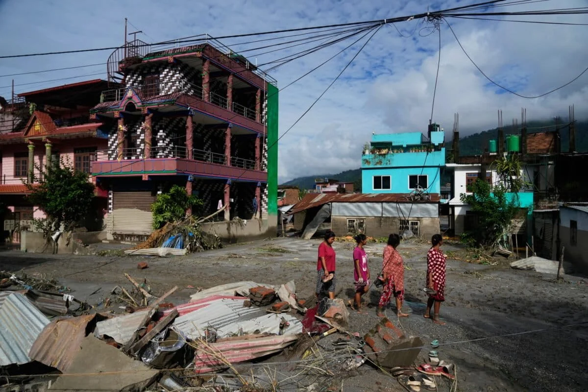
KATHMANDU / BEIJING — In the early hours of August 26, 2026, the fragile equilibrium of the High Himalayas shattered. Without the warning of a storm or the rumble of thunder, a massive section of the Langtang Lirung peak—a 7,245-meter titan—detached and plummeted into the Lhende Khola river. The resulting disaster has redefined the scale of cryospheric risk in the region, leaving hundreds dead and obliterating critical infrastructure across two nations.
This was not a disaster born of rain, but of heat. As global temperatures continue to climb, the "glue" of the Himalayas—permafrost and ancient glacial ice—is failing. The events of August 26 serve as a grim harbinger of a future where the world’s highest peaks are no longer solid ground, but volatile hazards.
I. Main Facts: A Disaster Without a Storm
The catastrophe began on the Tibet-Nepal border when a colossal mass of rock and ice, destabilized by a prolonged heatwave, sheared off the mountainside. The debris fell nearly 3,000 vertical meters into the Lhende Khola, a tributary that feeds into the Trishuli River system. The impact was so violent it registered as a localized earthquake, sending a shockwave through seismic monitoring stations across the Hindu Kush Himalayas (HKH).
The immediate consequence was a "wall of water" approximately nine meters high. This surge, a lethal slurry of boulders, pulverized ice, and mud, tore through the landscape at terminal velocity.
The Human and Economic Toll
While official figures are still being tabulated due to the remote nature of the impact zone, preliminary reports confirm:
- Casualties: Hundreds of individuals are confirmed dead or missing, including border officials, subsistence farmers, and hydroelectric technicians.
- Infrastructure: At least six dams and hydropower stations were swept away or rendered inoperable. The loss of these facilities represents a decade of energy investment for Nepal.
- Connectivity: Over a dozen crucial bridges—the lifelines of mountain communities—were snapped like toothpicks. Miles of the highway connecting the Rasuwagadhi border point to Kathmandu have been erased.
- Transboundary Impact: The flood was so powerful that its effects were felt hundreds of kilometers downstream in India, where a herd of five elephants was swept away by the rising Trishuli, illustrating the terrifying reach of Himalayan meltwater.
II. Chronology: From Silent Thaw to Sudden Collapse
The Prelude: A Summer of Anomalous Heat
The weeks leading up to August 26 were characterized by record-breaking temperatures across the Tibetan Plateau and the Nepalese highlands. Unlike typical monsoon seasons, where heavy rains trigger landslides, this period was unnervingly dry. Glaciologists note that this "dry heat" is particularly dangerous for steep, ice-clad peaks. As the internal temperature of the mountain rose, the permafrost holding the rock face to the glacial core began to liquefy.
August 26, 08:00 – 09:00 AM: The Collapse
The structural integrity of the Langtang Lirung slope reached its breaking point. In a matter of seconds, millions of cubic meters of debris transitioned from a solid state to a gravity-driven avalanche.
At the Jilong border land port on the Chinese side, there was no time for evacuation. The three-story Chinese government building, a symbol of modern engineering in the high-altitude desert, was erased within sixty seconds. On the opposite side of the gorge, at Rasuwagadhi, Nepal, the sudden roar of the river was the only warning residents had before the nine-meter surge arrived.
August 27 – 28: The Secondary Threat
By the morning of August 27, the immediate surge had passed, but a new crisis emerged. The sheer volume of rockfall had created an "impromptu dam" in the Lhende Khola. Satellite imagery revealed a rapidly growing lake forming behind a wall of unstable debris. Authorities in both China and Nepal were forced to issue urgent "fresh risk" warnings, fearing a secondary flash flood if this natural dam were to breach—a phenomenon known as a Landslide Dam Outburst Flood (LDOF).

III. Supporting Data: The Mechanics of Cryospheric Change
To understand the August 26 event, scientists point to the distinction between a standard flood and a "cryospheric collapse."
The Altitude Factor
The collapse originated at an elevation of over 7,000 meters. When debris falls from such heights, it gains immense kinetic energy. The friction generated during the fall can actually melt the ice within the debris, turning a dry rockfall into a highly mobile, liquid-like flow. This explains why the flood reached such high levels (9 meters) so quickly, despite the lack of rainfall.
Comparison to Chamoli (2021)
Experts draw direct parallels to the February 2021 disaster in Chamoli, Uttarakhand, India. In that instance, a similar mountainside collapse triggered a flood that killed over 200 people and destroyed the Tapovan Vishnugad hydropower plant. Both events occurred during periods of thermal instability and involved the failure of steep, ice-bonded rock faces rather than the breach of a visible glacial lake.
The "Third Pole" in Crisis
The Hindu Kush Himalayas hold the largest body of ice outside the polar regions, earning the moniker "The Third Pole." Data from the International Centre for Integrated Mountain Development (ICIMOD) shows that Himalayan glaciers are disappearing 65% faster in the 2010s than in the previous decade. More importantly, the permafrost—the invisible ice within the ground—is thawing at depths previously thought to be stable.
IV. Official Responses: A Call for Regional Synergy
The response to the Lhende Khola disaster has been a mix of desperate local rescue efforts and a renewed call for high-level diplomatic and scientific cooperation.
Field Rescue Operations
In Nepal’s Nuwakot district, rescuers have been seen using earthmovers to recover bodies from the thick silt left behind by the Trishuli River. The rugged terrain and destroyed bridges have made reaching the "ground zero" of the collapse nearly impossible by land, necessitating the use of military helicopters for reconnaissance and aid delivery.
The ICIMOD Mandate
Mohammed Farooq Azam, a senior cryosphere specialist at ICIMOD, has been vocal about the systemic failures that lead to such high casualty counts. "The pace of change is so rapid that current efforts are struggling to keep up," Azam stated. He emphasized that traditional "Early Warning Systems" (EWS) are designed for floods that build up over hours or days. They are currently useless against a mountainside that collapses in seconds.
The Regional Cryosphere Strategy
Just months prior to this disaster, a coalition of researchers proposed a "Regional Cryosphere Strategy." This framework calls for the eight HKH nations—Afghanistan, Bangladesh, Bhutan, China, India, Myanmar, Nepal, and Pakistan—to move beyond political rivalries and share real-time data.
The strategy focuses on four pillars:

- Standardized Monitoring: Moving from sporadic satellite checks to ground-based, interoperable sensors.
- Capacity Building: Training local engineers to recognize "slope instability" rather than just "flood risk."
- The HKH CryoHub: A centralized digital repository for policy-ready data.
- Operational Decision Support: Linking cryosphere trends directly to energy and infrastructure planning.
V. Implications: Engineering for an Unstable Future
The destruction of six dams in a single morning has sent shockwaves through the renewable energy sector. The Himalayas have been touted as the "battery of Asia," with dozens of hydropower projects planned to fuel the green transition in India and Nepal. However, the August 26 event suggests that the current engineering standards may be obsolete.
Rethinking Hydropower
Engineers must now account for "cascading hazards." A dam might be built to withstand a 100-year flood, but is it built to withstand a 9-meter wall of solid rock and ice? The financial risk to investors is becoming as steep as the mountains themselves. There is a growing movement among environmentalists to halt "run-of-the-river" projects in high-vulnerability zones until comprehensive slope-stability mapping is completed.
The Data Sovereignty Barrier
The greatest hurdle to safety remains political. In the HKH region, river flow data and geological surveys are often classified as matters of national security. China, India, and Nepal share the same water, but they do not always share the same data. The Lhende Khola disaster proves that a collapse in Tibet is a death sentence in Nepal and a crisis in India. Without "seamless data sharing," early warning remains a fantasy.
The Predictive Challenge
While monitoring glacial lakes (GLOFs) has become easier with satellite technology, predicting a mountainside collapse is infinitely harder. It requires mapping the internal thermal state of thousands of peaks. However, experts argue that we can no longer afford to wait. The use of AI-driven satellite analysis to identify "creeping" slopes—mountainsides that are moving by millimeters a year before they fail—must become a regional priority.
Conclusion: The Warning from Langtang Lirung
As the waters of the Lhende Khola begin to recede, leaving behind a scarred landscape of mud and broken concrete, the message is clear. The Himalayas are no longer the static, eternal sentinels of the north; they are dynamic, disintegrating landscapes.
The disaster of August 26, 2026, was not an "act of God" or a freak accident. It was the predictable result of a warming atmosphere acting on a fragile geological system. If the nations of the Hindu Kush Himalayas do not heed this warning and institutionalize a unified regional strategy, the "Third Pole" will continue to collapse, piece by piece, taking the lives and livelihoods of millions with it.
For the people of Rasuwagadhi and Jilong, the mountain didn’t just fall—it changed the rules of survival forever.
